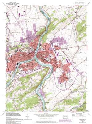
Easton Topo Map New Jersey
To zoom in, hover over the map of Easton
USGS Topo Quad 40075f2 - 1:24,000 scale
| Topo Map Name: | Easton |
| USGS Topo Quad ID: | 40075f2 |
| Print Size: | ca. 21 1/4" wide x 27" high |
| Southeast Coordinates: | 40.625° N latitude / 75.125° W longitude |
| Map Center Coordinates: | 40.6875° N latitude / 75.1875° W longitude |
| U.S. States: | NJ, PA |
| Filename: | o40075f2.jpg |
| Download Map JPG Image: | Easton topo map 1:24,000 scale |
| Map Type: | Topographic |
| Topo Series: | 7.5´ |
| Map Scale: | 1:24,000 |
| Source of Map Images: | United States Geological Survey (USGS) |
| Alternate Map Versions: |
Easton PA 1953 Download PDF Buy paper map Easton PA 1953, updated 1953 Download PDF Buy paper map Easton PA 1956, updated 1958 Download PDF Buy paper map Easton PA 1956, updated 1967 Download PDF Buy paper map Easton PA 1956, updated 1970 Download PDF Buy paper map Easton PA 1956, updated 1975 Download PDF Buy paper map Easton PA 1956, updated 1990 Download PDF Buy paper map Easton PA 1956, updated 1994 Download PDF Buy paper map Easton PA 1956, updated 1994 Download PDF Buy paper map Easton PA 1999, updated 2001 Download PDF Buy paper map Easton PA 2011 Download PDF Buy paper map Easton PA 2013 Download PDF Buy paper map Easton PA 2016 Download PDF Buy paper map |
1:24,000 Topo Quads surrounding Easton
> Back to 40075e1 at 1:100,000 scale
> Back to 40074a1 at 1:250,000 scale
> Back to U.S. Topo Maps home
Easton topo map: Gazetteer
Easton: Airports
Air-List-Ads Airport elevation 106m 347′Easton Airport elevation 118m 387′
Hartung Airport elevation 103m 337′
Ingersoll-Rand Company Heliport elevation 110m 360′
Warren Hospital Heliport elevation 123m 403′
Easton: Bridges
Chain Bridge (historical) elevation 55m 180′Easton: Canals
Pennsylvania Canal elevation 50m 164′Easton: Cliffs
Mount Washington elevation 88m 288′Saint Anthonys Nose elevation 77m 252′
Easton: Dams
Easton Dam elevation 45m 147′Lower Dam elevation 53m 173′
Mill Dam elevation 93m 305′
Upper Dam elevation 63m 206′
Walter Power Dam elevation 67m 219′
Easton: Islands
Getters Island elevation 49m 160′Old Sow Island elevation 44m 144′
Whippoorwill Island elevation 48m 157′
Easton: Mines
Williams Quarry elevation 60m 196′Easton: Parks
Condran Park elevation 88m 288′Hackett Park elevation 133m 436′
Heil Park elevation 103m 337′
Hugh Moore Park elevation 54m 177′
Meuser Park elevation 105m 344′
Nevin Park elevation 82m 269′
Pioneer Field elevation 92m 301′
Riverside Park elevation 47m 154′
Sullivan Park elevation 114m 374′
Walter Park elevation 85m 278′
Easton: Pillars
Elephant Rock elevation 231m 757′Easton: Populated Places
Alpha elevation 97m 318′Browntown elevation 116m 380′
Carpentersville elevation 50m 164′
Chestnut Hill elevation 127m 416′
Coilton elevation 91m 298′
Dietrichtown elevation 104m 341′
Easton elevation 97m 318′
Glendon elevation 70m 229′
Harmony elevation 147m 482′
Kennedys elevation 96m 314′
Lower Harmony elevation 147m 482′
Mutchlertown elevation 97m 318′
Odenweldertown elevation 62m 203′
Paxinosa elevation 129m 423′
Phillipsburg elevation 96m 314′
Port Warren elevation 79m 259′
Raubsville elevation 53m 173′
Shernerville elevation 54m 177′
South Easton elevation 99m 324′
Springtown elevation 61m 200′
Still Valley elevation 114m 374′
Uhlersville (historical) elevation 47m 154′
Uniontown elevation 120m 393′
Warren Glen elevation 63m 206′
West Easton elevation 82m 269′
Williamsport elevation 90m 295′
Wilson elevation 117m 383′
Zucksville elevation 81m 265′
Easton: Post Offices
Uhlersville Post Office (historical) elevation 47m 154′Easton: Reservoirs
Walters Mill Pond elevation 74m 242′Easton: Streams
Bushkill Creek elevation 76m 249′Lehigh River elevation 45m 147′
Lopatcong Creek elevation 44m 144′
Schoeneck Creek elevation 82m 269′
Easton: Summits
Bixlers Bluff elevation 62m 203′Chestnut Hill elevation 219m 718′
Marble Mountain elevation 235m 770′
Morgan Hill elevation 204m 669′
Easton: Valleys
Frost Hollow elevation 57m 187′Morgan Valley elevation 55m 180′
Easton digital topo map on disk
Buy this Easton topo map showing relief, roads, GPS coordinates and other geographical features, as a high-resolution digital map file on DVD:
Atlantic Coast (NY, NJ, PA, DE, MD, VA, NC)
Buy digital topo maps: Atlantic Coast (NY, NJ, PA, DE, MD, VA, NC)


