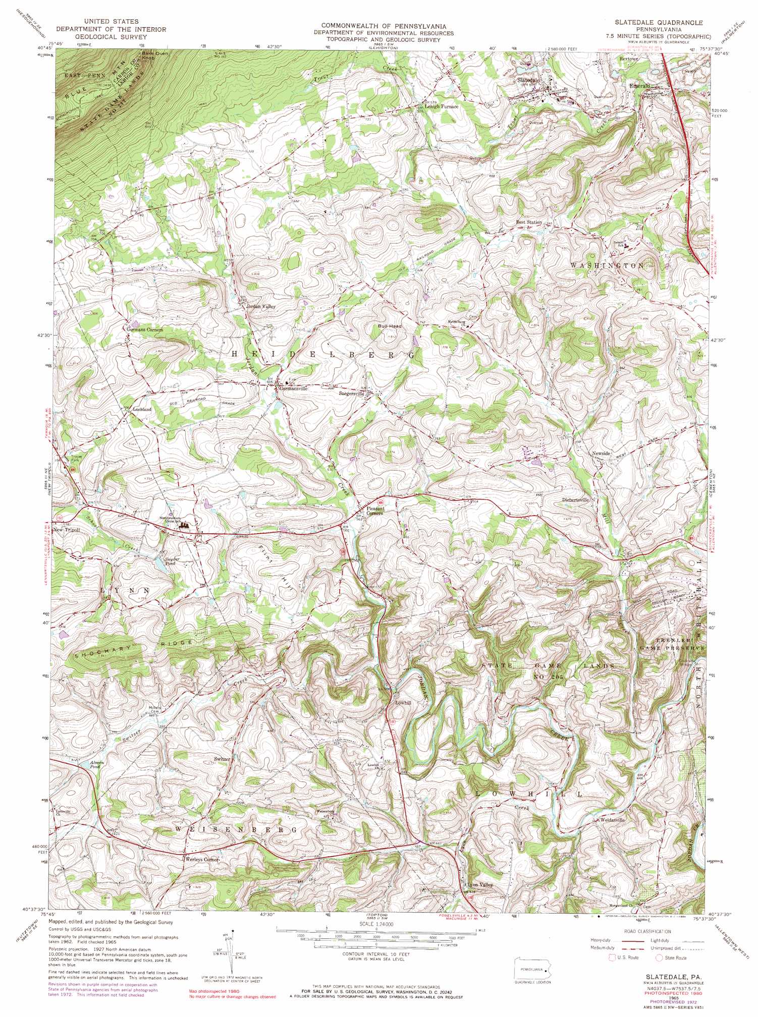
Slatedale Topo Map Pennsylvania
To zoom in, hover over the map of Slatedale
USGS Topo Quad 40075f6 - 1:24,000 scale
| Topo Map Name: | Slatedale |
| USGS Topo Quad ID: | 40075f6 |
| Print Size: | ca. 21 1/4" wide x 27" high |
| Southeast Coordinates: | 40.625° N latitude / 75.625° W longitude |
| Map Center Coordinates: | 40.6875° N latitude / 75.6875° W longitude |
| U.S. State: | PA |
| Filename: | o40075f6.jpg |
| Download Map JPG Image: | Slatedale topo map 1:24,000 scale |
| Map Type: | Topographic |
| Topo Series: | 7.5´ |
| Map Scale: | 1:24,000 |
| Source of Map Images: | United States Geological Survey (USGS) |
| Alternate Map Versions: |
Slatedale PA 1965, updated 1966 Download PDF Buy paper map Slatedale PA 1965, updated 1973 Download PDF Buy paper map Slatedale PA 1965, updated 1984 Download PDF Buy paper map Slatedale PA 1965, updated 1984 Download PDF Buy paper map Slatedale PA 1999, updated 2002 Download PDF Buy paper map Slatedale PA 2010 Download PDF Buy paper map Slatedale PA 2013 Download PDF Buy paper map Slatedale PA 2016 Download PDF Buy paper map |
1:24,000 Topo Quads surrounding Slatedale
Hazleton |
Weatherly |
Christmans |
Pohopoco Mountain |
Brodheadsville |
Tamaqua |
Nesquehoning |
Lehighton |
Palmerton |
Kunkletown |
New Ringgold |
New Tripoli |
Slatedale |
Cementon |
Catasauqua |
Hamburg |
Kutztown |
Topton |
Allentown West |
Allentown East |
Temple |
Fleetwood |
Manatawny |
East Greenville |
Milford Square |
> Back to 40075e1 at 1:100,000 scale
> Back to 40074a1 at 1:250,000 scale
> Back to U.S. Topo Maps home
Slatedale topo map: Gazetteer
Slatedale: Airports
Flying M Ranch Airport elevation 222m 728′Slatedale: Bridges
Schlicher Covered Bridge elevation 120m 393′Slatedale: Dams
Sand Spring Run Dam elevation 205m 672′Slatedale: Parks
State Game Lands Number 205 elevation 217m 711′Trexler Game Preserve elevation 215m 705′
Slatedale: Populated Places
Best Station elevation 172m 564′Bittners Corner elevation 178m 583′
Custer elevation 132m 433′
Diebertsville elevation 163m 534′
Emerald elevation 134m 439′
Germansville elevation 184m 603′
Jordan Valley elevation 193m 633′
Lehigh Furnace elevation 174m 570′
Lochland elevation 214m 702′
Lyon Valley elevation 141m 462′
Newside elevation 183m 600′
Peters Store elevation 191m 626′
Pleasant Corners elevation 173m 567′
Saegersville elevation 194m 636′
Slatedale elevation 154m 505′
Switzer elevation 188m 616′
Weidasville elevation 131m 429′
Werleys Corner elevation 213m 698′
Slatedale: Reservoirs
Alvern Pond elevation 181m 593′Sand Spring Lake elevation 205m 672′
Synder Pond elevation 192m 629′
Slatedale: Streams
Cherith Brook elevation 124m 406′Lyon Creek elevation 127m 416′
Mill Creek elevation 122m 400′
Switzer Creek elevation 152m 498′
Slatedale: Summits
Bake Oven Knob elevation 483m 1584′Bull Head elevation 247m 810′
Flint Hill elevation 231m 757′
Lowhill elevation 210m 688′
Mill Hill elevation 220m 721′
Slatedale digital topo map on disk
Buy this Slatedale topo map showing relief, roads, GPS coordinates and other geographical features, as a high-resolution digital map file on DVD:
Atlantic Coast (NY, NJ, PA, DE, MD, VA, NC)
Buy digital topo maps: Atlantic Coast (NY, NJ, PA, DE, MD, VA, NC)
 map DVD")