Kunkletown Topo Map Pennsylvania
To zoom in, hover over the map of Kunkletown
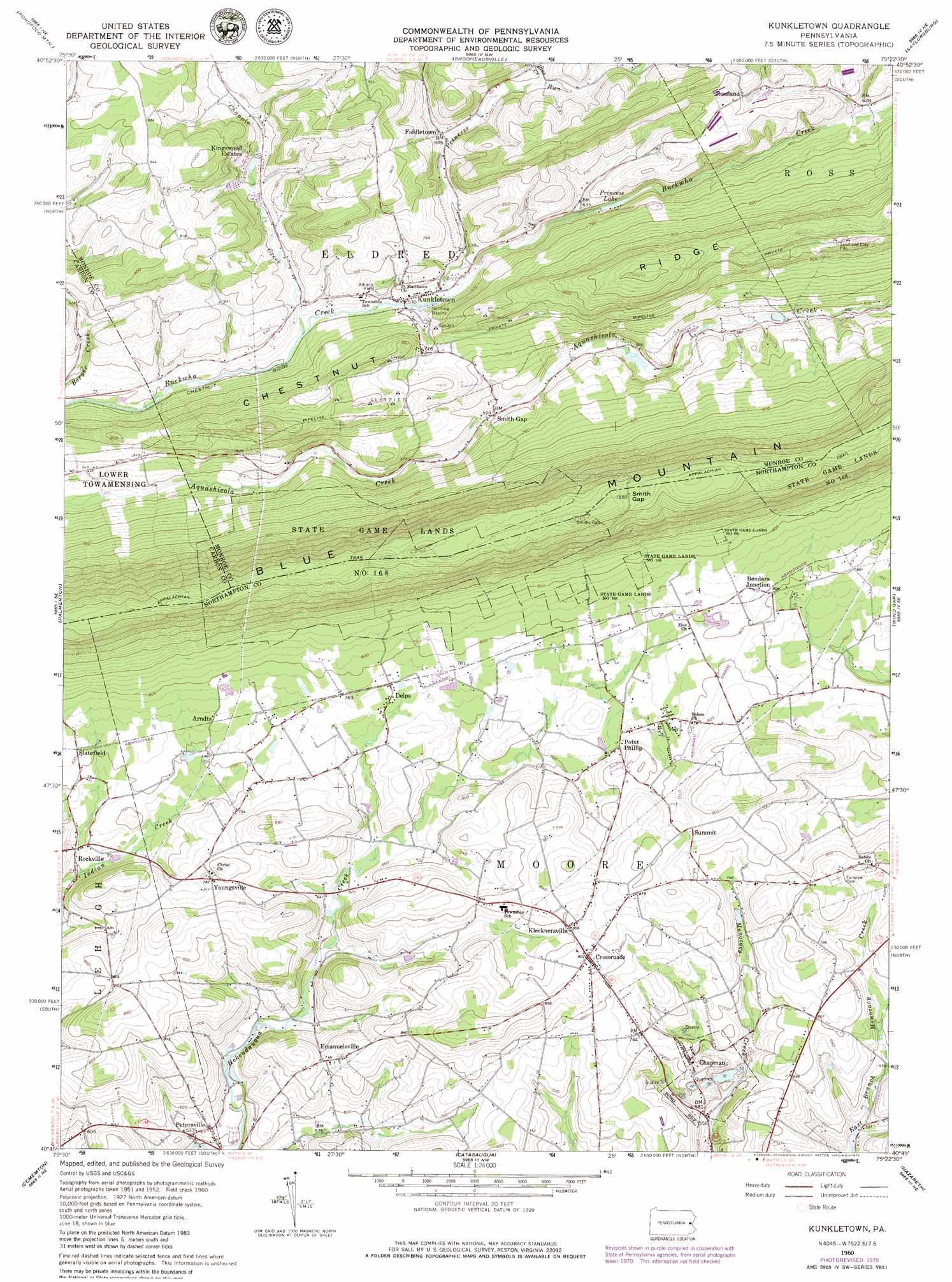
USGS Topo Quad 40075g4 - 1:24,000 scale
| Topo Map Name: | Kunkletown |
| USGS Topo Quad ID: | 40075g4 |
| Print Size: | ca. 21 1/4" wide x 27" high |
| Southeast Coordinates: | 40.75° N latitude / 75.375° W longitude |
| Map Center Coordinates: | 40.8125° N latitude / 75.4375° W longitude |
| U.S. State: | PA |
| Filename: | o40075g4.jpg |
| Download Map JPG Image: | Kunkletown topo map 1:24,000 scale |
| Map Type: | Topographic |
| Topo Series: | 7.5´ |
| Map Scale: | 1:24,000 |
| Source of Map Images: | United States Geological Survey (USGS) |
| Alternate Map Versions: |
Kunkletown PA 1960, updated 1962 Download PDF Buy paper map Kunkletown PA 1960, updated 1968 Download PDF Buy paper map Kunkletown PA 1960, updated 1972 Download PDF Buy paper map Kunkletown PA 1976, updated 1978 Download PDF Buy paper map Kunkletown PA 1992, updated 1995 Download PDF Buy paper map Kunkletown PA 1997, updated 1999 Download PDF Buy paper map Kunkletown PA 2010 Download PDF Buy paper map Kunkletown PA 2013 Download PDF Buy paper map Kunkletown PA 2016 Download PDF Buy paper map |
1:24,000 Topo Quads surrounding Kunkletown
Hickory Run |
Blakeslee |
Pocono Pines |
Mount Pocono |
East Stroudsburg |
Christmans |
Pohopoco Mountain |
Brodheadsville |
Saylorsburg |
Stroudsburg |
Lehighton |
Palmerton |
Kunkletown |
Wind Gap |
Bangor |
Slatedale |
Cementon |
Catasauqua |
Nazareth |
Easton |
Topton |
Allentown West |
Allentown East |
Hellertown |
Riegelsville |
> Back to 40075e1 at 1:100,000 scale
> Back to 40074a1 at 1:250,000 scale
> Back to U.S. Topo Maps home
Kunkletown topo map: Gazetteer
Kunkletown: Dams
Water Supply Dam elevation 451m 1479′Kunkletown: Gaps
Smith Gap elevation 473m 1551′Kunkletown: Lakes
Princess Lake elevation 165m 541′Kunkletown: Parks
Plainview Park (historical) elevation 162m 531′State Game Lands Number 168 elevation 433m 1420′
Kunkletown: Populated Places
Arndts elevation 223m 731′Benders Junction elevation 250m 820′
Castle Garden elevation 226m 741′
Chapman elevation 215m 705′
Crossroads elevation 250m 820′
Delps elevation 228m 748′
Emanuelsville elevation 220m 721′
Fiddletown elevation 199m 652′
Kingswood Estates elevation 197m 646′
Klecknersville elevation 245m 803′
Kunkletown elevation 161m 528′
Petersville elevation 165m 541′
Point Phillip elevation 231m 757′
Rockville elevation 190m 623′
Rossland elevation 243m 797′
Slatefield elevation 221m 725′
Smith Gap elevation 165m 541′
Youngsville elevation 240m 787′
Kunkletown: Reservoirs
Blue Mount Lake elevation 211m 692′Evergreen Lake elevation 244m 800′
Lake Tu Peek elevation 230m 754′
Kunkletown: Ridges
Chestnut Ridge elevation 375m 1230′Kunkletown: Streams
Chapple Creek elevation 156m 511′Frantzs Creek elevation 161m 528′
Pine Creek elevation 210m 688′
Princess Run elevation 159m 521′
Kunkletown digital topo map on disk
Buy this Kunkletown topo map showing relief, roads, GPS coordinates and other geographical features, as a high-resolution digital map file on DVD:
Atlantic Coast (NY, NJ, PA, DE, MD, VA, NC)
Buy digital topo maps: Atlantic Coast (NY, NJ, PA, DE, MD, VA, NC)
 map DVD")