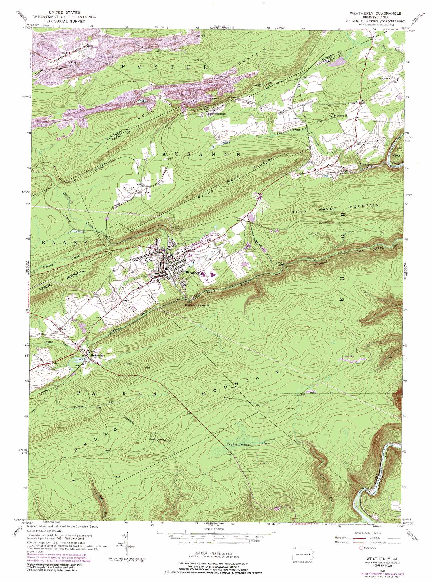
Weatherly Topo Map Pennsylvania
To zoom in, hover over the map of Weatherly
USGS Topo Quad 40075h7 - 1:24,000 scale
| Topo Map Name: | Weatherly |
| USGS Topo Quad ID: | 40075h7 |
| Print Size: | ca. 21 1/4" wide x 27" high |
| Southeast Coordinates: | 40.875° N latitude / 75.75° W longitude |
| Map Center Coordinates: | 40.9375° N latitude / 75.8125° W longitude |
| U.S. State: | PA |
| Filename: | o40075h7.jpg |
| Download Map JPG Image: | Weatherly topo map 1:24,000 scale |
| Map Type: | Topographic |
| Topo Series: | 7.5´ |
| Map Scale: | 1:24,000 |
| Source of Map Images: | United States Geological Survey (USGS) |
| Alternate Map Versions: |
Weatherly PA 1948, updated 1965 Download PDF Buy paper map Weatherly PA 1948, updated 1969 Download PDF Buy paper map Weatherly PA 1948, updated 1972 Download PDF Buy paper map Weatherly PA 1948, updated 1977 Download PDF Buy paper map Weatherly PA 1948, updated 1990 Download PDF Buy paper map Weatherly PA 1948, updated 1990 Download PDF Buy paper map Weatherly PA 1950 Download PDF Buy paper map Weatherly PA 1950 Download PDF Buy paper map Weatherly PA 1976, updated 1979 Download PDF Buy paper map Weatherly PA 1999, updated 2002 Download PDF Buy paper map Weatherly PA 2010 Download PDF Buy paper map Weatherly PA 2013 Download PDF Buy paper map Weatherly PA 2016 Download PDF Buy paper map |
1:24,000 Topo Quads surrounding Weatherly
Nanticoke |
Wilkes-Barre West |
Wilkes-Barre East |
Pleasant View Summit |
Thornhurst |
Sybertsville |
Freeland |
White Haven |
Hickory Run |
Blakeslee |
Conyngham |
Hazleton |
Weatherly |
Christmans |
Pohopoco Mountain |
Delano |
Tamaqua |
Nesquehoning |
Lehighton |
Palmerton |
Orwigsburg |
New Ringgold |
New Tripoli |
Slatedale |
Cementon |
> Back to 40075e1 at 1:100,000 scale
> Back to 40074a1 at 1:250,000 scale
> Back to U.S. Topo Maps home
Weatherly topo map: Gazetteer
Weatherly: Bridges
Hazle Creek Bridge elevation 406m 1332′Weatherly: Dams
Beisel Run Dam elevation 345m 1131′Indian Run Dam elevation 337m 1105′
Quakake Dam elevation 338m 1108′
Upper Buck Mountain Dam elevation 377m 1236′
Weatherly: Populated Places
Black Creek Junction elevation 303m 994′Buck Mountain elevation 399m 1309′
Eckley elevation 504m 1653′
Hudsondale elevation 335m 1099′
Rockport elevation 309m 1013′
Weather elevation 342m 1122′
Weatherly elevation 331m 1085′
Weatherly: Reservoirs
Eurana Park Pool elevation 341m 1118′Quakake Lake elevation 338m 1108′
Weatherly: Streams
Beaver Creek elevation 412m 1351′Brushy Hollow Run elevation 273m 895′
Buck Mountain Creek elevation 268m 879′
Hazle Creek elevation 412m 1351′
Indian Run elevation 308m 1010′
Koons Creek elevation 336m 1102′
Nesquehoning Creek elevation 172m 564′
Oberson Run elevation 363m 1190′
Quakake Creek elevation 316m 1036′
Schaffers Run elevation 354m 1161′
Wetzel Creek elevation 329m 1079′
Weatherly: Summits
Broad Mountain elevation 549m 1801′Penn Haven Mountain elevation 447m 1466′
Round Head Mountain elevation 537m 1761′
Weatherly: Swamps
Hughes Swamp elevation 476m 1561′Weatherly: Valleys
Brushy Hollow elevation 273m 895′Glen Onoko elevation 175m 574′
Weatherly digital topo map on disk
Buy this Weatherly topo map showing relief, roads, GPS coordinates and other geographical features, as a high-resolution digital map file on DVD:
Atlantic Coast (NY, NJ, PA, DE, MD, VA, NC)
Buy digital topo maps: Atlantic Coast (NY, NJ, PA, DE, MD, VA, NC)
 map DVD")