Lancaster Topo Map Pennsylvania
To zoom in, hover over the map of Lancaster
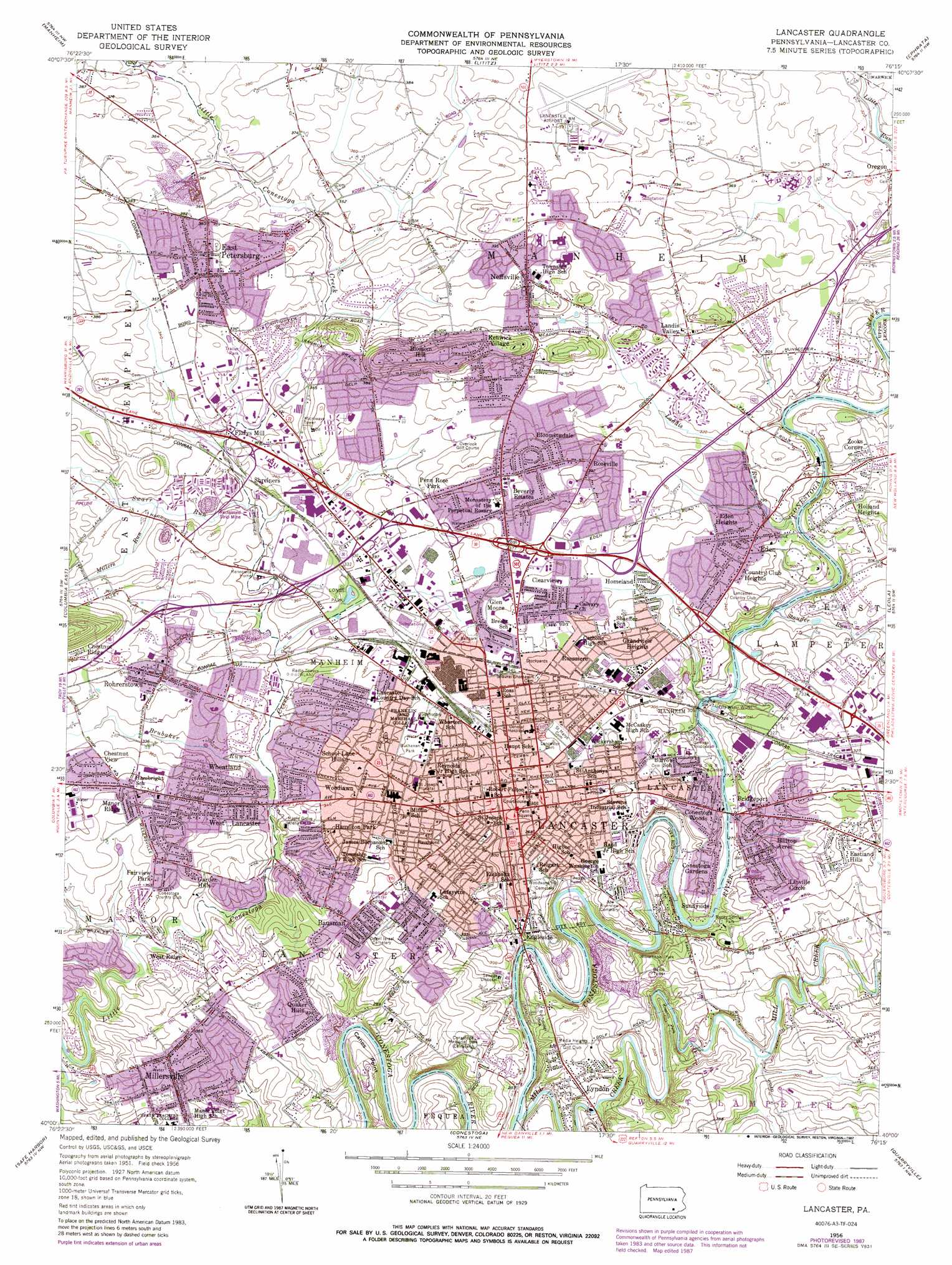
USGS Topo Quad 40076a3 - 1:24,000 scale
| Topo Map Name: | Lancaster |
| USGS Topo Quad ID: | 40076a3 |
| Print Size: | ca. 21 1/4" wide x 27" high |
| Southeast Coordinates: | 40° N latitude / 76.25° W longitude |
| Map Center Coordinates: | 40.0625° N latitude / 76.3125° W longitude |
| U.S. State: | PA |
| Filename: | o40076a3.jpg |
| Download Map JPG Image: | Lancaster topo map 1:24,000 scale |
| Map Type: | Topographic |
| Topo Series: | 7.5´ |
| Map Scale: | 1:24,000 |
| Source of Map Images: | United States Geological Survey (USGS) |
| Alternate Map Versions: |
Lancaster PA 1956, updated 1958 Download PDF Buy paper map Lancaster PA 1956, updated 1962 Download PDF Buy paper map Lancaster PA 1956, updated 1970 Download PDF Buy paper map Lancaster PA 1956, updated 1977 Download PDF Buy paper map Lancaster PA 1956, updated 1987 Download PDF Buy paper map Lancaster PA 1995, updated 1996 Download PDF Buy paper map Lancaster PA 1997, updated 2000 Download PDF Buy paper map Lancaster PA 2010 Download PDF Buy paper map Lancaster PA 2013 Download PDF Buy paper map Lancaster PA 2016 Download PDF Buy paper map |
1:24,000 Topo Quads surrounding Lancaster
Palmyra |
Lebanon |
Richland |
Womelsdorf |
Sinking Spring |
Elizabethtown |
Manheim |
Lititz |
Ephrata |
Terre Hill |
Columbia West |
Columbia East |
Lancaster |
Leola |
New Holland |
Red Lion |
Safe Harbor |
Conestoga |
Quarryville |
Gap |
Stewartstown |
Airville |
Holtwood |
Wakefield |
Kirkwood |
> Back to 40076a1 at 1:100,000 scale
> Back to 40076a1 at 1:250,000 scale
> Back to U.S. Topo Maps home
Lancaster topo map: Gazetteer
Lancaster: Airports
Habecker Airport elevation 109m 357′Hamilton Bank Heliport elevation 104m 341′
Lancaster Airport elevation 120m 393′
Lancaster General Hospital Heliport elevation 116m 380′
Noll Airport elevation 109m 357′
RCA-Lancaster Heliport elevation 95m 311′
Thomson Heliport elevation 93m 305′
Lancaster: Cliffs
Canes Point elevation 86m 282′Indian Rock elevation 91m 298′
Lancaster: Mines
Benners Quarry elevation 80m 262′Fruitville Quarry elevation 121m 396′
Lancaster: Parks
Brandon Park elevation 85m 278′Buchanan Park elevation 129m 423′
Buchmiller Park elevation 90m 295′
Catholic High School Stadium elevation 107m 351′
Colin Field elevation 90m 295′
Conestoga Pines Park elevation 94m 308′
Crystal Park elevation 115m 377′
Crystal Park elevation 115m 377′
East Petersburg Civic Grounds elevation 117m 383′
Franklin and Marshall Athletic Field elevation 102m 334′
Kiwanis Park elevation 86m 282′
Lancaster County Park elevation 88m 288′
Lancaster Jaycee Park elevation 97m 318′
Lancaster Municipal Park elevation 121m 396′
Longs Park elevation 98m 321′
Manheim Township Community Park elevation 127m 416′
Manor Township Community Park elevation 82m 269′
Martin Greider Park elevation 114m 374′
Millersville Borough Park elevation 102m 334′
Musser Park elevation 120m 393′
Northeast Neighborhood Park elevation 109m 357′
Overlook Park elevation 110m 360′
Reservoir Park elevation 96m 314′
Rocky Springs Park elevation 98m 321′
Sixth Ward Park elevation 97m 318′
Skyline Park elevation 109m 357′
South End Park elevation 89m 291′
Sponaugle-Williamson Field elevation 121m 396′
Stauffer Park elevation 107m 351′
Triangle Park elevation 112m 367′
Williamson Park elevation 92m 301′
Lancaster: Populated Places
Bausman elevation 123m 403′Beverly Estates elevation 128m 419′
Bloomingdale elevation 129m 423′
Blossom Hill elevation 153m 501′
Bridgeport elevation 109m 357′
Brooklawn elevation 119m 390′
Chestnut Ridge elevation 132m 433′
Chestnut View elevation 122m 400′
Clearview elevation 110m 360′
Colonial Manor elevation 100m 328′
Conestoga Gardens elevation 89m 291′
Conestoga Woods elevation 85m 278′
Country Club Heights elevation 101m 331′
East Petersburg elevation 113m 370′
Eastland Hills elevation 116m 380′
Eden elevation 102m 334′
Eden Heights elevation 98m 321′
Engleside elevation 85m 278′
Fairview Park elevation 107m 351′
Florys Mill elevation 97m 318′
Fruitville elevation 125m 410′
Garden Hills elevation 114m 374′
Glen Moore elevation 103m 337′
Grandview Heights elevation 104m 341′
Hamilton Park elevation 110m 360′
Hilltop Acres elevation 91m 298′
Holland Heights elevation 108m 354′
Homeland elevation 98m 321′
Kenwick Village elevation 135m 442′
Lancaster elevation 110m 360′
Landis Valley elevation 108m 354′
Linville Circle elevation 104m 341′
Lyndon elevation 102m 334′
Manor Ridge elevation 122m 400′
McGovernsville elevation 109m 357′
Neffsville elevation 122m 400′
Penn Rose Park elevation 124m 406′
Quaker Hills elevation 111m 364′
Rohrerstown elevation 109m 357′
Roseville elevation 119m 390′
Rossmere elevation 103m 337′
Shreiners elevation 97m 318′
Sunnyside elevation 84m 275′
West Lampeter elevation 90m 295′
West Lancaster elevation 109m 357′
West Ridge elevation 90m 295′
Wheatland elevation 103m 337′
Woodlawn elevation 116m 380′
Wynn Wood Manor elevation 118m 387′
Zooks Corner elevation 110m 360′
Lancaster: Post Offices
Binkleys Bridge Post Office (historical) elevation 87m 285′East Hempfield Post Office (historical) elevation 113m 370′
Hempfield Post Office (historical) elevation 109m 357′
Manheim Post Office (historical) elevation 122m 400′
Lancaster: Springs
Rocky Spring elevation 92m 301′Lancaster: Streams
Bachman Run elevation 96m 314′Big Spring Run elevation 81m 265′
Brubaker Run elevation 87m 285′
Fox Rill elevation 63m 206′
Landis Run elevation 77m 252′
Mill Creek elevation 68m 223′
Millers Run elevation 95m 311′
Stauffer Run elevation 75m 246′
Swarr Run elevation 89m 291′
Lancaster digital topo map on disk
Buy this Lancaster topo map showing relief, roads, GPS coordinates and other geographical features, as a high-resolution digital map file on DVD:
Atlantic Coast (NY, NJ, PA, DE, MD, VA, NC)
Buy digital topo maps: Atlantic Coast (NY, NJ, PA, DE, MD, VA, NC)
 map DVD")