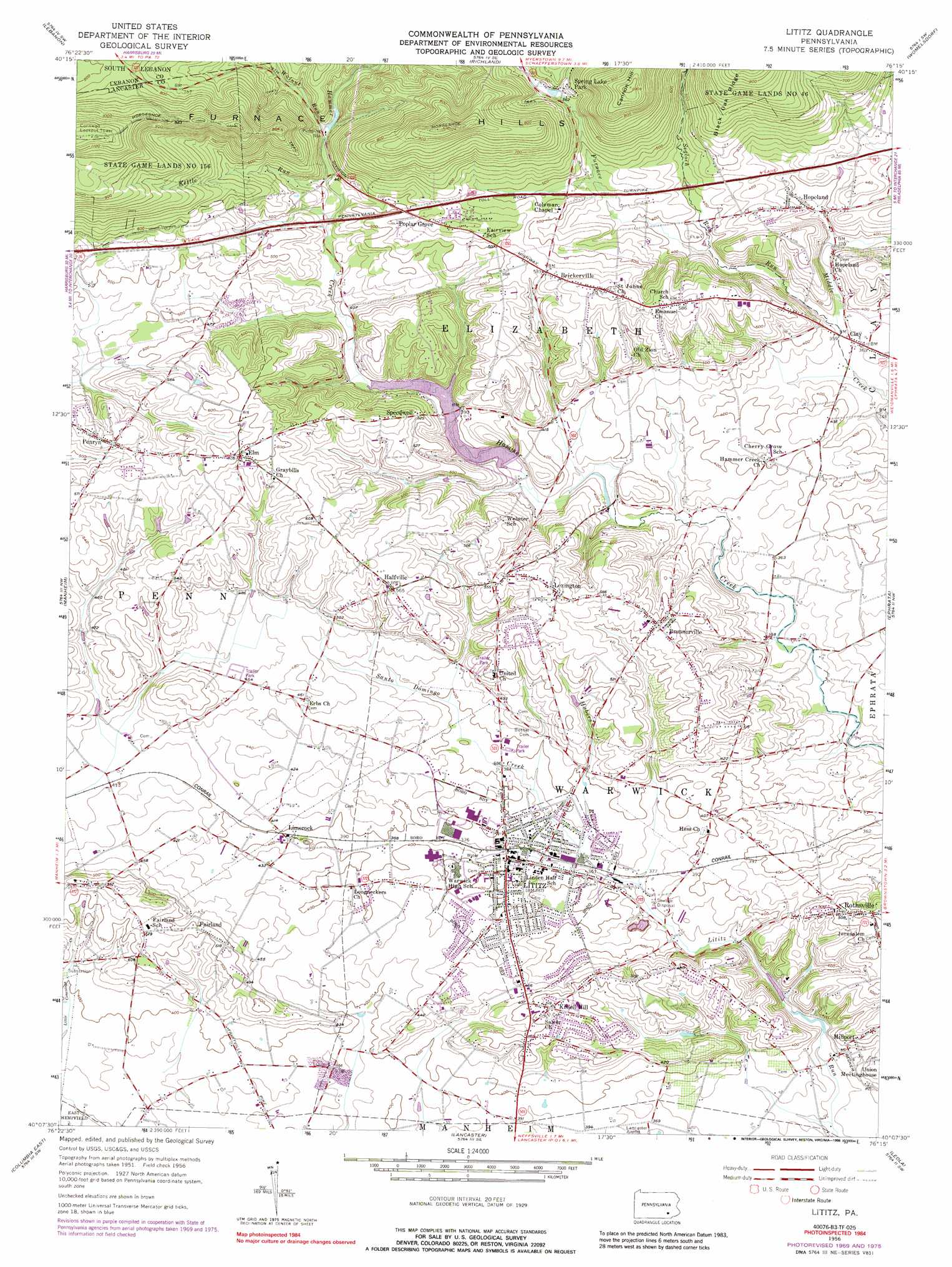
Lititz Topo Map Pennsylvania
To zoom in, hover over the map of Lititz
USGS Topo Quad 40076b3 - 1:24,000 scale
| Topo Map Name: | Lititz |
| USGS Topo Quad ID: | 40076b3 |
| Print Size: | ca. 21 1/4" wide x 27" high |
| Southeast Coordinates: | 40.125° N latitude / 76.25° W longitude |
| Map Center Coordinates: | 40.1875° N latitude / 76.3125° W longitude |
| U.S. State: | PA |
| Filename: | o40076b3.jpg |
| Download Map JPG Image: | Lititz topo map 1:24,000 scale |
| Map Type: | Topographic |
| Topo Series: | 7.5´ |
| Map Scale: | 1:24,000 |
| Source of Map Images: | United States Geological Survey (USGS) |
| Alternate Map Versions: |
Lititz PA 1956, updated 1957 Download PDF Buy paper map Lititz PA 1956, updated 1966 Download PDF Buy paper map Lititz PA 1956, updated 1970 Download PDF Buy paper map Lititz PA 1956, updated 1977 Download PDF Buy paper map Lititz PA 1956, updated 1988 Download PDF Buy paper map Lititz PA 1995, updated 1996 Download PDF Buy paper map Lititz PA 2010 Download PDF Buy paper map Lititz PA 2013 Download PDF Buy paper map Lititz PA 2016 Download PDF Buy paper map |
1:24,000 Topo Quads surrounding Lititz
Indiantown Gap |
Fredericksburg |
Bethel |
Strausstown |
Bernville |
Palmyra |
Lebanon |
Richland |
Womelsdorf |
Sinking Spring |
Elizabethtown |
Manheim |
Lititz |
Ephrata |
Terre Hill |
Columbia West |
Columbia East |
Lancaster |
Leola |
New Holland |
Red Lion |
Safe Harbor |
Conestoga |
Quarryville |
Gap |
> Back to 40076a1 at 1:100,000 scale
> Back to 40076a1 at 1:250,000 scale
> Back to U.S. Topo Maps home
Lititz topo map: Gazetteer
Lititz: Airports
Shenk Airport elevation 126m 413′Warner-Lambert Heliport elevation 121m 396′
Lititz: Lakes
Spring Lake elevation 166m 544′Lititz: Parks
Lions Club Park elevation 122m 400′Lititz Springs Park elevation 115m 377′
Locust Street Park elevation 114m 374′
Spring Lake Park elevation 172m 564′
State Game Lands Number 46 elevation 255m 836′
Woodridge Swim Club elevation 142m 465′
Lititz: Populated Places
Brickerville elevation 164m 538′Brunnerville elevation 159m 521′
Clay elevation 108m 354′
Elm elevation 184m 603′
Fairland elevation 153m 501′
Halfville elevation 171m 561′
Hopeland elevation 122m 400′
Kissell Hill elevation 160m 524′
Lexington elevation 178m 583′
Limerock elevation 121m 396′
Lititz elevation 117m 383′
Millport elevation 125m 410′
Penryn elevation 178m 583′
Poplar Grove elevation 174m 570′
Rothsville elevation 150m 492′
Speedwell elevation 160m 524′
Warwick elevation 121m 396′
Lititz: Post Offices
Brickerville Post Office (historical) elevation 164m 538′Brunersville Post Office (historical) elevation 159m 521′
Elm Post Office (historical) elevation 184m 603′
Lititz Post Office (historical) elevation 117m 383′
Penn Post Office (historical) elevation 184m 603′
Rothsville Post Office (historical) elevation 150m 492′
Lititz: Reservoirs
Speedwell Forge Dam elevation 117m 383′Lititz: Ridges
Cannon Hill elevation 305m 1000′Lititz: Springs
Lititz Spring elevation 115m 377′Lititz: Streams
Furnace Run elevation 107m 351′Hubers Run elevation 112m 367′
Kettle Run elevation 127m 416′
New Haven Run elevation 97m 318′
Santo Domingo Creek elevation 109m 357′
Segloch Run elevation 112m 367′
Walnut Run elevation 132m 433′
Lititz: Summits
Eagle Rock elevation 281m 921′Lititz digital topo map on disk
Buy this Lititz topo map showing relief, roads, GPS coordinates and other geographical features, as a high-resolution digital map file on DVD:
Atlantic Coast (NY, NJ, PA, DE, MD, VA, NC)
Buy digital topo maps: Atlantic Coast (NY, NJ, PA, DE, MD, VA, NC)
 map DVD")