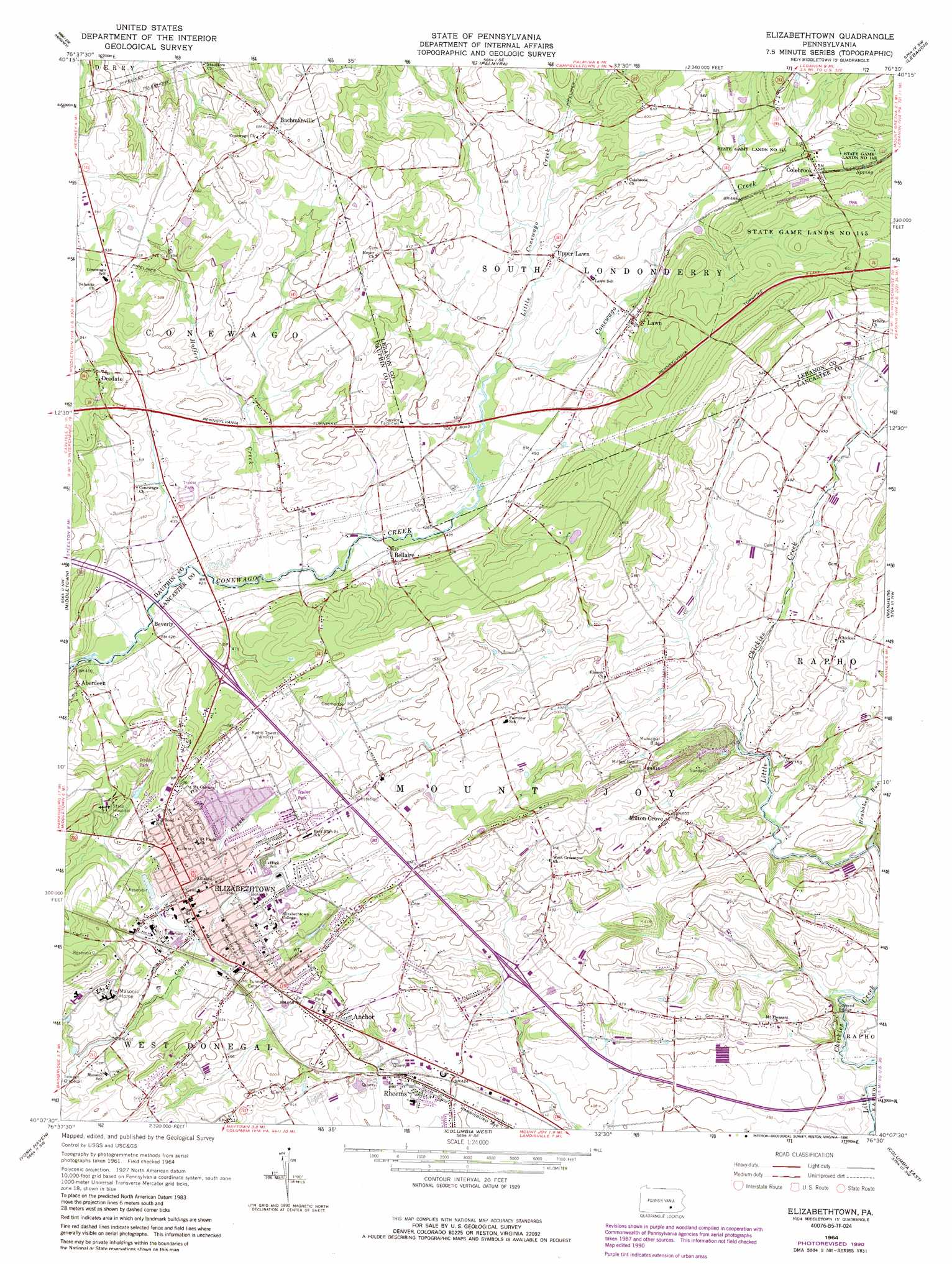
Elizabethtown Topo Map Pennsylvania
To zoom in, hover over the map of Elizabethtown
USGS Topo Quad 40076b5 - 1:24,000 scale
| Topo Map Name: | Elizabethtown |
| USGS Topo Quad ID: | 40076b5 |
| Print Size: | ca. 21 1/4" wide x 27" high |
| Southeast Coordinates: | 40.125° N latitude / 76.5° W longitude |
| Map Center Coordinates: | 40.1875° N latitude / 76.5625° W longitude |
| U.S. State: | PA |
| Filename: | o40076b5.jpg |
| Download Map JPG Image: | Elizabethtown topo map 1:24,000 scale |
| Map Type: | Topographic |
| Topo Series: | 7.5´ |
| Map Scale: | 1:24,000 |
| Source of Map Images: | United States Geological Survey (USGS) |
| Alternate Map Versions: |
Elizabethtown PA 1964, updated 1965 Download PDF Buy paper map Elizabethtown PA 1964, updated 1973 Download PDF Buy paper map Elizabethtown PA 1964, updated 1978 Download PDF Buy paper map Elizabethtown PA 1964, updated 1990 Download PDF Buy paper map Elizabethtown PA 1999, updated 2001 Download PDF Buy paper map Elizabethtown PA 2010 Download PDF Buy paper map Elizabethtown PA 2013 Download PDF Buy paper map Elizabethtown PA 2016 Download PDF Buy paper map |
1:24,000 Topo Quads surrounding Elizabethtown
Enders |
Grantville |
Indiantown Gap |
Fredericksburg |
Bethel |
Harrisburg East |
Hershey |
Palmyra |
Lebanon |
Richland |
Steelton |
Middletown |
Elizabethtown |
Manheim |
Lititz |
Dover |
York Haven |
Columbia West |
Columbia East |
Lancaster |
West York |
York |
Red Lion |
Safe Harbor |
Conestoga |
> Back to 40076a1 at 1:100,000 scale
> Back to 40076a1 at 1:250,000 scale
> Back to U.S. Topo Maps home
Elizabethtown topo map: Gazetteer
Elizabethtown: Mines
Rheems Quarry elevation 129m 423′Elizabethtown: Parks
Elizabethtown Borough Park elevation 133m 436′State Game Lands Number 145 elevation 176m 577′
Elizabethtown: Pillars
Dinosaur Rock elevation 193m 633′Elizabethtown: Populated Places
Aberdeen elevation 134m 439′Anchor elevation 164m 538′
Bachmanville elevation 185m 606′
Bellaire elevation 139m 456′
Beverly elevation 128m 419′
Colebrook elevation 167m 547′
Deodate elevation 176m 577′
Elizabethtown elevation 136m 446′
Lawn elevation 146m 479′
Milton Grove elevation 154m 505′
Rheems elevation 132m 433′
Upper Lawn elevation 146m 479′
Elizabethtown: Streams
Brubaker Run elevation 112m 367′Gallagher Run elevation 127m 416′
Hoffer Creek elevation 127m 416′
Little Conewago Creek elevation 132m 433′
Shells Run elevation 117m 383′
Elizabethtown digital topo map on disk
Buy this Elizabethtown topo map showing relief, roads, GPS coordinates and other geographical features, as a high-resolution digital map file on DVD:
Atlantic Coast (NY, NJ, PA, DE, MD, VA, NC)
Buy digital topo maps: Atlantic Coast (NY, NJ, PA, DE, MD, VA, NC)
 map DVD")