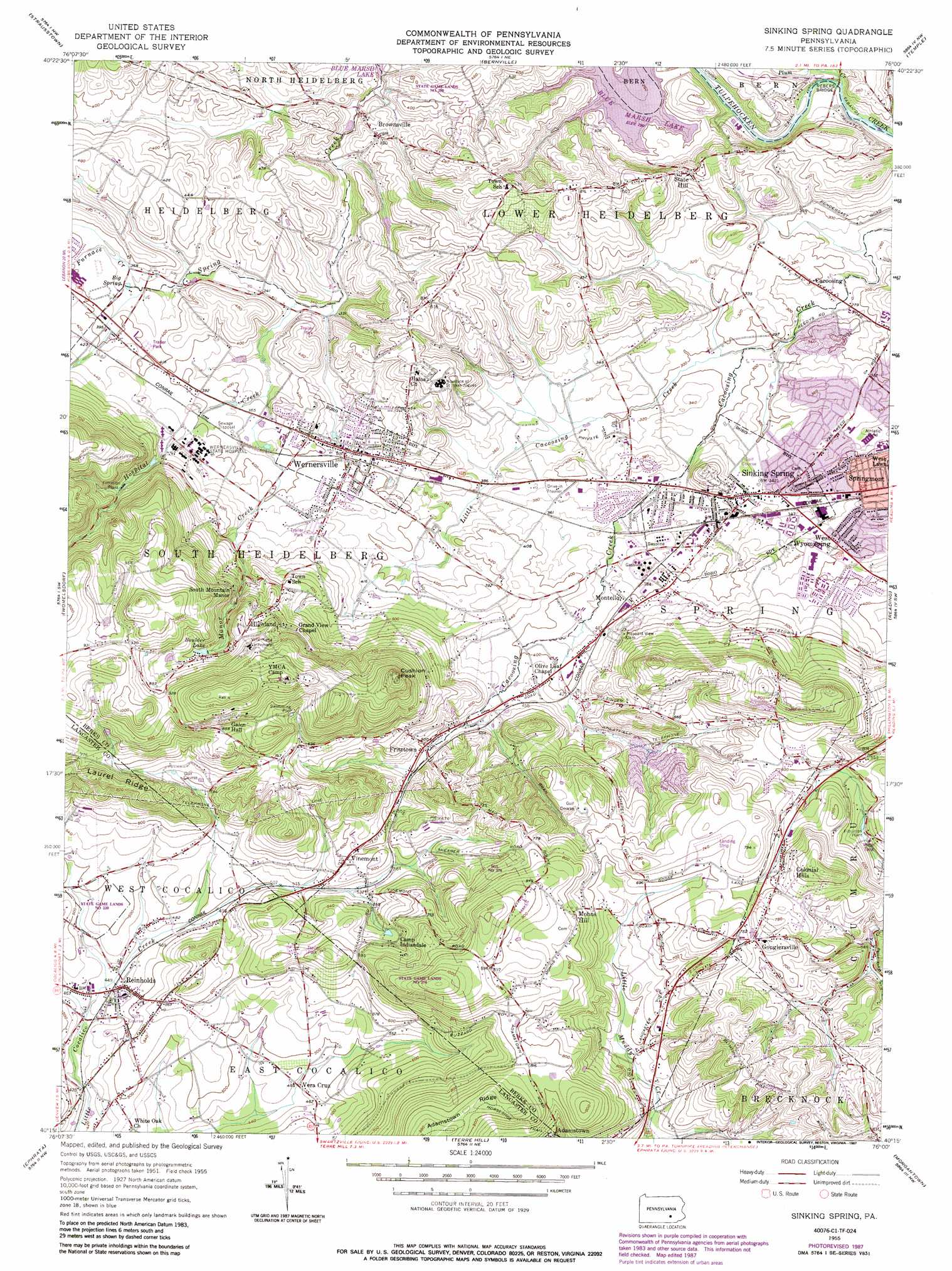
Sinking Spring Topo Map Pennsylvania
To zoom in, hover over the map of Sinking Spring
USGS Topo Quad 40076c1 - 1:24,000 scale
| Topo Map Name: | Sinking Spring |
| USGS Topo Quad ID: | 40076c1 |
| Print Size: | ca. 21 1/4" wide x 27" high |
| Southeast Coordinates: | 40.25° N latitude / 76° W longitude |
| Map Center Coordinates: | 40.3125° N latitude / 76.0625° W longitude |
| U.S. State: | PA |
| Filename: | o40076c1.jpg |
| Download Map JPG Image: | Sinking Spring topo map 1:24,000 scale |
| Map Type: | Topographic |
| Topo Series: | 7.5´ |
| Map Scale: | 1:24,000 |
| Source of Map Images: | United States Geological Survey (USGS) |
| Alternate Map Versions: |
Sinking Spring PA 1955, updated 1956 Download PDF Buy paper map Sinking Spring PA 1955, updated 1965 Download PDF Buy paper map Sinking Spring PA 1955, updated 1969 Download PDF Buy paper map Sinking Spring PA 1955, updated 1975 Download PDF Buy paper map Sinking Spring PA 1955, updated 1977 Download PDF Buy paper map Sinking Spring PA 1955, updated 1987 Download PDF Buy paper map Sinking Spring PA 1999, updated 2001 Download PDF Buy paper map Sinking Spring PA 2010 Download PDF Buy paper map Sinking Spring PA 2013 Download PDF Buy paper map Sinking Spring PA 2016 Download PDF Buy paper map |
1:24,000 Topo Quads surrounding Sinking Spring
Swatara Hill |
Friedensburg |
Auburn |
Hamburg |
Kutztown |
Bethel |
Strausstown |
Bernville |
Temple |
Fleetwood |
Richland |
Womelsdorf |
Sinking Spring |
Reading |
Birdsboro |
Lititz |
Ephrata |
Terre Hill |
Morgantown |
Elverson |
Lancaster |
Leola |
New Holland |
Honey Brook |
Wagontown |
> Back to 40076a1 at 1:100,000 scale
> Back to 40076a1 at 1:250,000 scale
> Back to U.S. Topo Maps home
Sinking Spring topo map: Gazetteer
Sinking Spring: Airports
Boyer Airport elevation 154m 505′Sinking Spring: Bridges
Rebers Bridge elevation 94m 308′Sinking Spring: Dams
Blue Marsh Dike C elevation 93m 305′Boulder Lake Dam elevation 238m 780′
Mill Dam elevation 147m 482′
Schnader Dam elevation 167m 547′
Wernersville Hospital Dam elevation 147m 482′
Sinking Spring: Parks
Breneman Park elevation 93m 305′Cacoosing Meadows Recreation Area elevation 85m 278′
Chapel Gate Township Park elevation 143m 469′
Cornwall Terrace Park elevation 122m 400′
Heritage Park elevation 103m 337′
Klines Creek Park elevation 183m 600′
Len Oak Park elevation 119m 390′
Midvale Manor Park elevation 123m 403′
Shiloh Hills Park elevation 229m 751′
Sinking Spring Playground elevation 107m 351′
Socialist Park elevation 98m 321′
South Mountain Park elevation 161m 528′
State Game Lands Number 220 elevation 154m 505′
State Game Lands Number 274 elevation 136m 446′
State Game Lands Number 280 elevation 129m 423′
Wernersville Park elevation 111m 364′
Wernersville Playlot elevation 116m 380′
West Cocalico Township Park elevation 136m 446′
Sinking Spring: Populated Places
Blue Marsh (historical) elevation 94m 308′Brownsville elevation 110m 360′
Cacoosing elevation 81m 265′
Colonial Hills elevation 213m 698′
Cornwall Terrace elevation 124m 406′
Fritztown elevation 146m 479′
Gouglersville elevation 225m 738′
Green Valley Estates elevation 97m 318′
Green Valley Gardens elevation 97m 318′
Grings Hill Estates elevation 201m 659′
Highland elevation 224m 734′
Mohns Hill elevation 241m 790′
Montello elevation 128m 419′
Phoebe Berks Village elevation 135m 442′
Reinholds elevation 141m 462′
Shiloh Hills elevation 233m 764′
Sinking Spring elevation 123m 403′
Sinking Spring Terrace elevation 126m 413′
Spring Dale Heights elevation 184m 603′
State Hill elevation 151m 495′
Tallowyck elevation 184m 603′
Vera Cruz elevation 139m 456′
Villa Maria Infirmary elevation 289m 948′
Vinemont elevation 182m 597′
Wernersville elevation 114m 374′
Wheaton Heights elevation 205m 672′
Whitfield elevation 104m 341′
Wilshire Hills elevation 104m 341′
Sinking Spring: Reservoirs
Boulder Lake elevation 231m 757′Jesuit Center Pool elevation 161m 528′
South Mountain YMCA Pool elevation 309m 1013′
Wilshire Recreation Association Pool elevation 107m 351′
Sinking Spring: Ridges
Adamstown Ridge elevation 304m 997′Laurel Ridge elevation 261m 856′
Sinking Spring: Springs
Big Spring elevation 110m 360′Reedy Spring elevation 83m 272′
Sinking Spring: Streams
Furnace Creek elevation 108m 354′Hospital Creek elevation 112m 367′
Little Cacoosing Creek elevation 85m 278′
Manor Creek elevation 106m 347′
Plum Creek elevation 107m 351′
Sinking Spring: Summits
Cushion Peak elevation 320m 1049′South Mountain Manor elevation 196m 643′
Sinking Spring: Trails
Cacoosing Creek Trail elevation 79m 259′Squirrel Run Nature Trail elevation 92m 301′
Sinking Spring digital topo map on disk
Buy this Sinking Spring topo map showing relief, roads, GPS coordinates and other geographical features, as a high-resolution digital map file on DVD:
Atlantic Coast (NY, NJ, PA, DE, MD, VA, NC)
Buy digital topo maps: Atlantic Coast (NY, NJ, PA, DE, MD, VA, NC)
 map DVD")