Indiantown Gap Topo Map Pennsylvania
To zoom in, hover over the map of Indiantown Gap
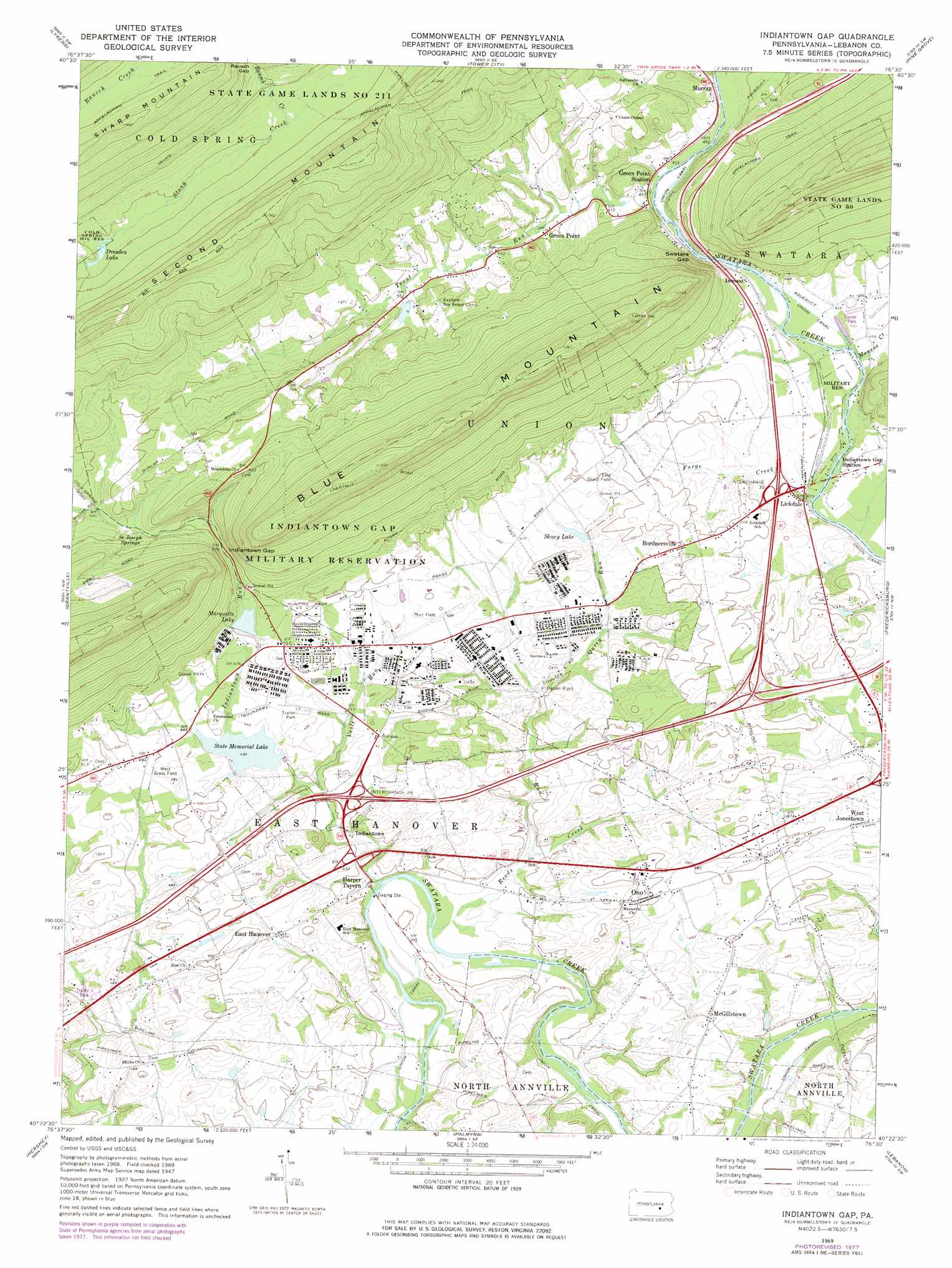
USGS Topo Quad 40076d5 - 1:24,000 scale
| Topo Map Name: | Indiantown Gap |
| USGS Topo Quad ID: | 40076d5 |
| Print Size: | ca. 21 1/4" wide x 27" high |
| Southeast Coordinates: | 40.375° N latitude / 76.5° W longitude |
| Map Center Coordinates: | 40.4375° N latitude / 76.5625° W longitude |
| U.S. State: | PA |
| Filename: | o40076d5.jpg |
| Download Map JPG Image: | Indiantown Gap topo map 1:24,000 scale |
| Map Type: | Topographic |
| Topo Series: | 7.5´ |
| Map Scale: | 1:24,000 |
| Source of Map Images: | United States Geological Survey (USGS) |
| Alternate Map Versions: |
Indiantown Gap PA 1947, updated 1947 Download PDF Buy paper map Indiantown Gap PA 1947, updated 1964 Download PDF Buy paper map Indiantown Gap PA 1969, updated 1972 Download PDF Buy paper map Indiantown Gap PA 1969, updated 1977 Download PDF Buy paper map Indiantown Gap PA 1977, updated 1979 Download PDF Buy paper map Indiantown Gap PA 1999, updated 2001 Download PDF Buy paper map Indiantown Gap PA 2010 Download PDF Buy paper map Indiantown Gap PA 2013 Download PDF Buy paper map Indiantown Gap PA 2016 Download PDF Buy paper map |
1:24,000 Topo Quads surrounding Indiantown Gap
Pillow |
Klingerstown |
Valley View |
Tremont |
Minersville |
Elizabethville |
Lykens |
Tower City |
Pine Grove |
Swatara Hill |
Enders |
Grantville |
Indiantown Gap |
Fredericksburg |
Bethel |
Harrisburg East |
Hershey |
Palmyra |
Lebanon |
Richland |
Steelton |
Middletown |
Elizabethtown |
Manheim |
Lititz |
> Back to 40076a1 at 1:100,000 scale
> Back to 40076a1 at 1:250,000 scale
> Back to U.S. Topo Maps home
Indiantown Gap topo map: Gazetteer
Indiantown Gap: Airports
Dee Jay Airport elevation 147m 482′Indiantown Gap: Dams
Memorial Lake Dam elevation 132m 433′Reservation Dam elevation 155m 508′
Shuey Lake Dam elevation 147m 482′
Stouffer Lake Dam elevation 170m 557′
Indiantown Gap: Gaps
Indiantown Gap elevation 179m 587′Rausch Gap elevation 296m 971′
Swatara Gap elevation 132m 433′
Indiantown Gap: Lakes
Dresden Lake elevation 232m 761′Indiantown Gap: Parks
Bashore Boy Scout Camp elevation 200m 656′Memorial Lake State Park elevation 132m 433′
State Game Lands Number 80 elevation 234m 767′
Swatara State Park elevation 153m 501′
Indiantown Gap: Populated Places
Bordnersville elevation 153m 501′East Hanover elevation 138m 452′
Fort Indiantown Gap elevation 174m 570′
Green Point elevation 153m 501′
Harper Tavern elevation 116m 380′
Indiantown elevation 113m 370′
Inwood elevation 133m 436′
Lickdale elevation 130m 426′
McGillstown elevation 144m 472′
Murray elevation 143m 469′
Ono elevation 156m 511′
Indiantown Gap: Post Offices
Ono Post Office elevation 154m 505′Indiantown Gap: Reservoirs
Marquette Lake elevation 157m 515′Shuey Lake elevation 132m 433′
Stouffer Lake elevation 170m 557′
Indiantown Gap: Springs
Saint Joseph Springs elevation 195m 639′Indiantown Gap: Streams
Aires Run elevation 114m 374′Forge Creek elevation 125m 410′
Indiantown Run elevation 109m 357′
Monroe Creek elevation 128m 419′
Qureg Run elevation 124m 406′
Rausch Creek elevation 247m 810′
Reeds Creek elevation 110m 360′
Trout Run elevation 133m 436′
Vesle Run elevation 120m 393′
Woods Creek elevation 129m 423′
Indiantown Gap: Valleys
Monroe Valley elevation 139m 456′Indiantown Gap digital topo map on disk
Buy this Indiantown Gap topo map showing relief, roads, GPS coordinates and other geographical features, as a high-resolution digital map file on DVD:
Atlantic Coast (NY, NJ, PA, DE, MD, VA, NC)
Buy digital topo maps: Atlantic Coast (NY, NJ, PA, DE, MD, VA, NC)
 map DVD")