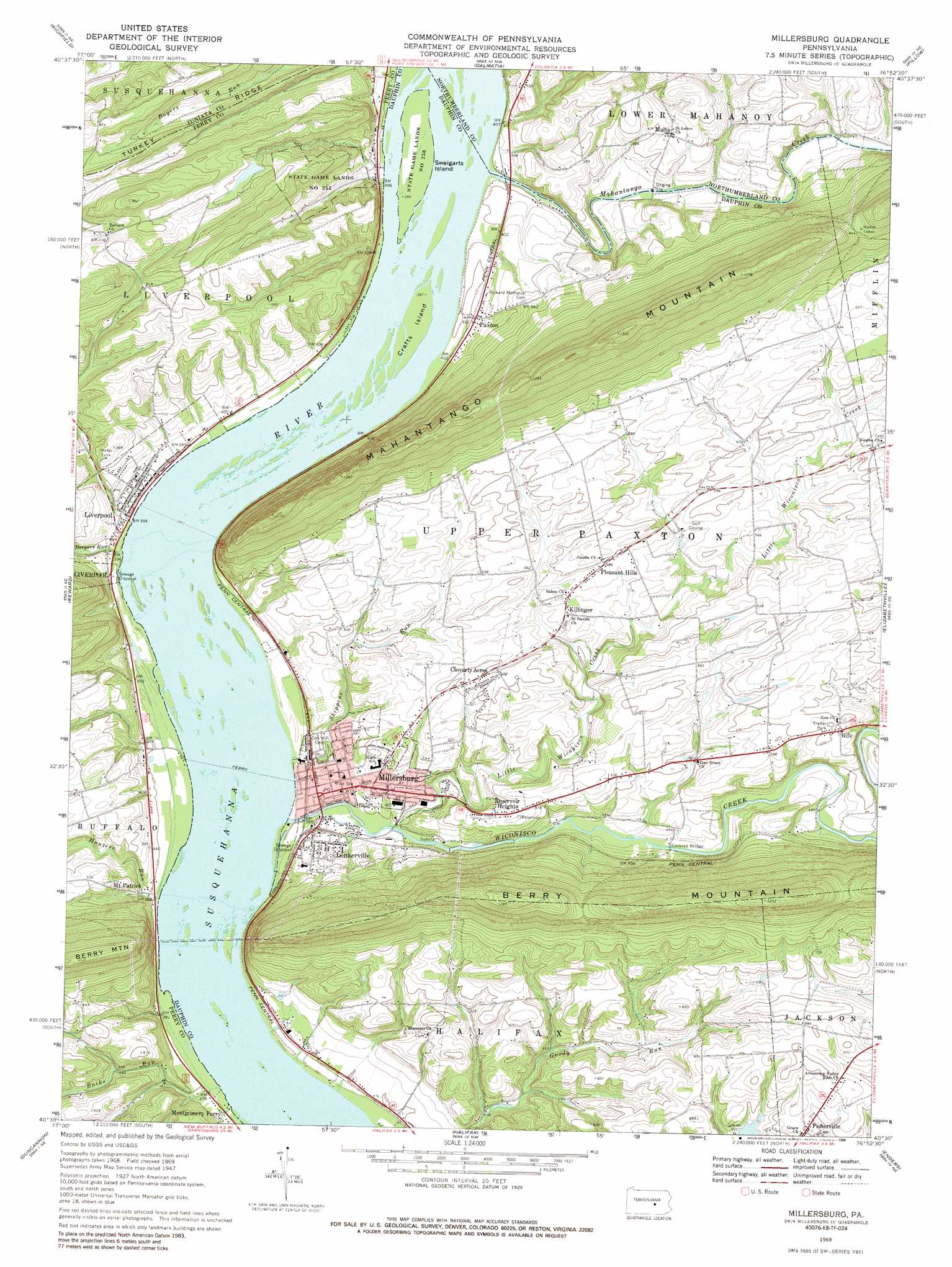
Millersburg Topo Map Pennsylvania
To zoom in, hover over the map of Millersburg
USGS Topo Quad 40076e8 - 1:24,000 scale
| Topo Map Name: | Millersburg |
| USGS Topo Quad ID: | 40076e8 |
| Print Size: | ca. 21 1/4" wide x 27" high |
| Southeast Coordinates: | 40.5° N latitude / 76.875° W longitude |
| Map Center Coordinates: | 40.5625° N latitude / 76.9375° W longitude |
| U.S. State: | PA |
| Filename: | o40076e8.jpg |
| Download Map JPG Image: | Millersburg topo map 1:24,000 scale |
| Map Type: | Topographic |
| Topo Series: | 7.5´ |
| Map Scale: | 1:24,000 |
| Source of Map Images: | United States Geological Survey (USGS) |
| Alternate Map Versions: |
Millersburg PA 1947 Download PDF Buy paper map Millersburg PA 1947, updated 1968 Download PDF Buy paper map Millersburg PA 1969, updated 1972 Download PDF Buy paper map Millersburg PA 1969, updated 1972 Download PDF Buy paper map Millersburg PA 1969, updated 1977 Download PDF Buy paper map Millersburg PA 1969, updated 1988 Download PDF Buy paper map Millersburg PA 1977, updated 1979 Download PDF Buy paper map Millersburg PA 1999, updated 2001 Download PDF Buy paper map Millersburg PA 2010 Download PDF Buy paper map Millersburg PA 2013 Download PDF Buy paper map Millersburg PA 2016 Download PDF Buy paper map |
1:24,000 Topo Quads surrounding Millersburg
Beavertown |
Middleburg |
Freeburg |
Sunbury |
Trevorton |
Beaver Springs |
Richfield |
Dalmatia |
Pillow |
Klingerstown |
Millerstown |
Reward |
Millersburg |
Elizabethville |
Lykens |
Newport |
Duncannon |
Halifax |
Enders |
Grantville |
Shermans Dale |
Wertzville |
Harrisburg West |
Harrisburg East |
Hershey |
> Back to 40076e1 at 1:100,000 scale
> Back to 40076a1 at 1:250,000 scale
> Back to U.S. Topo Maps home
Millersburg topo map: Gazetteer
Millersburg: Dams
Kaercher Creek Dam elevation 110m 360′Markunas Dam elevation 208m 682′
Millersburg: Gaps
Susquehanna Water Gaps elevation 110m 360′Millersburg: Islands
Crafts Island elevation 118m 387′Sweigarts Island elevation 116m 380′
Millersburg: Parks
State Game Lands Number 258 elevation 153m 501′Millersburg: Populated Places
Cloverly Acres elevation 183m 600′Fisherville elevation 187m 613′
Killinger elevation 169m 554′
Lenkerville elevation 126m 413′
Liverpool elevation 122m 400′
Malta elevation 165m 541′
Millersburg elevation 131m 429′
Mount Patrick elevation 119m 390′
Paxton elevation 131m 429′
Pleasant Hills elevation 180m 590′
Reservoir Heights elevation 161m 528′
Rife elevation 180m 590′
Millersburg: Reservoirs
Pa-478 Reservoir elevation 110m 360′Millersburg: Streams
Bargers Run elevation 110m 360′Boyers Run elevation 117m 383′
Bucks Run elevation 110m 360′
Hunters Run elevation 110m 360′
Little Wiconisco Creek elevation 121m 396′
Mahantango Creek elevation 122m 400′
Shippens Run elevation 115m 377′
Wiconisco Creek elevation 116m 380′
Millersburg: Valleys
Bucks Valley elevation 117m 383′Hunters Valley elevation 110m 360′
Millersburg digital topo map on disk
Buy this Millersburg topo map showing relief, roads, GPS coordinates and other geographical features, as a high-resolution digital map file on DVD:
Atlantic Coast (NY, NJ, PA, DE, MD, VA, NC)
Buy digital topo maps: Atlantic Coast (NY, NJ, PA, DE, MD, VA, NC)
 map DVD")