Mechanicsburg Topo Map Pennsylvania
To zoom in, hover over the map of Mechanicsburg
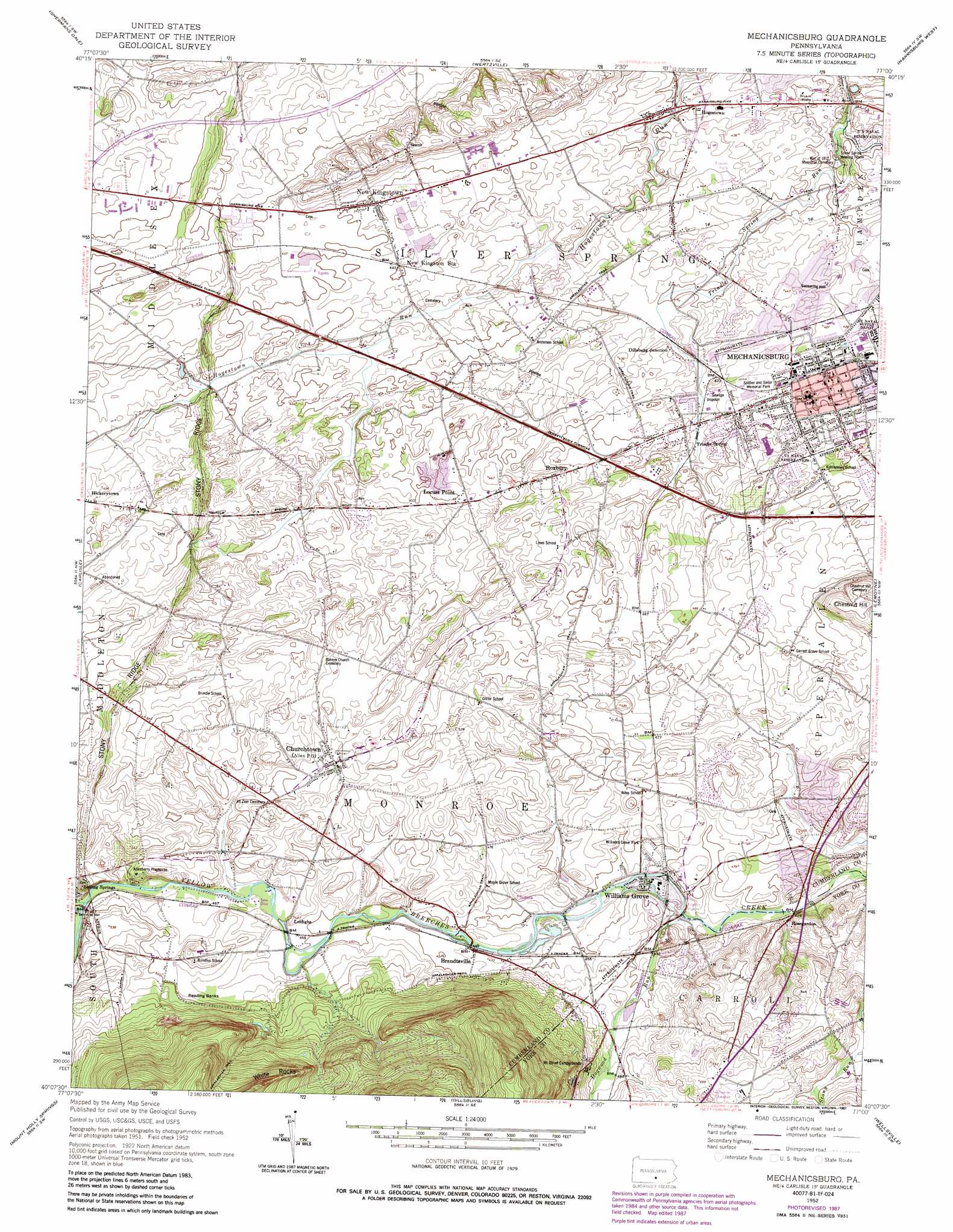
USGS Topo Quad 40077b1 - 1:24,000 scale
| Topo Map Name: | Mechanicsburg |
| USGS Topo Quad ID: | 40077b1 |
| Print Size: | ca. 21 1/4" wide x 27" high |
| Southeast Coordinates: | 40.125° N latitude / 77° W longitude |
| Map Center Coordinates: | 40.1875° N latitude / 77.0625° W longitude |
| U.S. State: | PA |
| Filename: | o40077b1.jpg |
| Download Map JPG Image: | Mechanicsburg topo map 1:24,000 scale |
| Map Type: | Topographic |
| Topo Series: | 7.5´ |
| Map Scale: | 1:24,000 |
| Source of Map Images: | United States Geological Survey (USGS) |
| Alternate Map Versions: |
Mechanicsburg PA 1952, updated 1958 Download PDF Buy paper map Mechanicsburg PA 1952, updated 1967 Download PDF Buy paper map Mechanicsburg PA 1952, updated 1969 Download PDF Buy paper map Mechanicsburg PA 1952, updated 1975 Download PDF Buy paper map Mechanicsburg PA 1952, updated 1978 Download PDF Buy paper map Mechanicsburg PA 1952, updated 1987 Download PDF Buy paper map Mechanicsburg PA 1999, updated 2001 Download PDF Buy paper map Mechanicsburg PA 2010 Download PDF Buy paper map Mechanicsburg PA 2013 Download PDF Buy paper map Mechanicsburg PA 2016 Download PDF Buy paper map |
1:24,000 Topo Quads surrounding Mechanicsburg
Ickesburg |
Newport |
Duncannon |
Halifax |
Enders |
Landisburg |
Shermans Dale |
Wertzville |
Harrisburg West |
Harrisburg East |
Plainfield |
Carlisle |
Mechanicsburg |
Lemoyne |
Steelton |
Dickinson |
Mount Holly Springs |
Dillsburg |
Wellsville |
Dover |
Arendtsville |
Biglerville |
Hampton |
Abbottstown |
West York |
> Back to 40077a1 at 1:100,000 scale
> Back to 40076a1 at 1:250,000 scale
> Back to U.S. Topo Maps home
Mechanicsburg topo map: Gazetteer
Mechanicsburg: Airports
Neiderer Airport elevation 146m 479′Taylor Aviation Air Field elevation 133m 436′
Williams Grove Heliport elevation 128m 419′
Mechanicsburg: Parks
Center Square Park elevation 132m 433′Rose Garden Park elevation 135m 442′
Soldier and Sailor Memorial Park elevation 130m 426′
Williams Grove Park elevation 136m 446′
Mechanicsburg: Populated Places
Allen elevation 156m 511′Berkshire Hills elevation 144m 472′
Brandtsville elevation 134m 439′
Carroll Manor elevation 156m 511′
Churchtown elevation 157m 515′
Country Estates elevation 151m 495′
Dillsburg Junction elevation 125m 410′
Hogestown elevation 120m 393′
Kingtown elevation 163m 534′
Le High Park elevation 160m 524′
Leidighs elevation 137m 449′
Liebys Trailer Park elevation 139m 456′
Locust Point elevation 140m 459′
Mechanicsburg elevation 132m 433′
New Kingstown elevation 135m 442′
Rose Garden elevation 142m 465′
Rosegarden elevation 135m 442′
Roxbury elevation 141m 462′
Sunnyland elevation 140m 459′
Trindle Springs elevation 134m 439′
Valley Stream Estates elevation 128m 419′
Webercroft elevation 134m 439′
White Rock Acres elevation 253m 830′
Williams Grove elevation 128m 419′
Mechanicsburg: Ridges
Stony Ridge elevation 162m 531′Mechanicsburg: Slopes
Reading Banks elevation 158m 518′Mechanicsburg: Springs
Hidden Spring elevation 137m 449′Silver Spring elevation 114m 374′
Trindle Spring elevation 134m 439′
Mechanicsburg: Streams
Dogwood Run elevation 129m 423′Fishers Run elevation 152m 498′
Mechanicsburg: Summits
Chestnut Hill elevation 185m 606′Mechanicsburg digital topo map on disk
Buy this Mechanicsburg topo map showing relief, roads, GPS coordinates and other geographical features, as a high-resolution digital map file on DVD:
Atlantic Coast (NY, NJ, PA, DE, MD, VA, NC)
Buy digital topo maps: Atlantic Coast (NY, NJ, PA, DE, MD, VA, NC)
 map DVD")