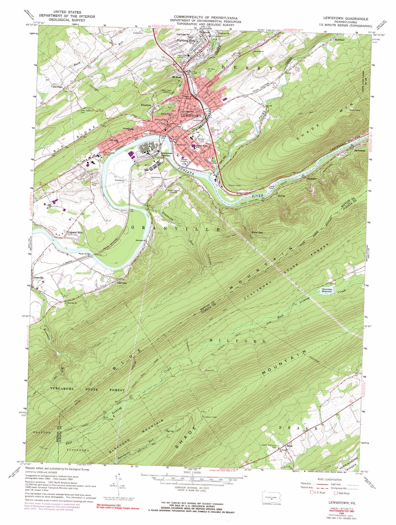
Lewistown Topo Map Pennsylvania
To zoom in, hover over the map of Lewistown
USGS Topo Quad 40077e5 - 1:24,000 scale
| Topo Map Name: | Lewistown |
| USGS Topo Quad ID: | 40077e5 |
| Print Size: | ca. 21 1/4" wide x 27" high |
| Southeast Coordinates: | 40.5° N latitude / 77.5° W longitude |
| Map Center Coordinates: | 40.5625° N latitude / 77.5625° W longitude |
| U.S. State: | PA |
| Filename: | o40077e5.jpg |
| Download Map JPG Image: | Lewistown topo map 1:24,000 scale |
| Map Type: | Topographic |
| Topo Series: | 7.5´ |
| Map Scale: | 1:24,000 |
| Source of Map Images: | United States Geological Survey (USGS) |
| Alternate Map Versions: |
Lewistown PA 1966, updated 1968 Download PDF Buy paper map Lewistown PA 1966, updated 1973 Download PDF Buy paper map Lewistown PA 1966, updated 1991 Download PDF Buy paper map Lewistown PA 1977, updated 1979 Download PDF Buy paper map Lewistown PA 2010 Download PDF Buy paper map Lewistown PA 2013 Download PDF Buy paper map Lewistown PA 2016 Download PDF Buy paper map |
1:24,000 Topo Quads surrounding Lewistown
State College |
Centre Hall |
Spring Mills |
Coburn |
Weikert |
Mcalevys Fort |
Barrville |
Burnham |
Alfarata |
Mcclure |
Allensville |
Belleville |
Lewistown |
Mifflintown |
Mexico |
Newton Hamilton |
Mcveytown |
Mccoysville |
Spruce Hill |
Ickesburg |
Aughwick |
Blairs Mills |
Blain |
Andersonburg |
Landisburg |
> Back to 40077e1 at 1:100,000 scale
> Back to 40076a1 at 1:250,000 scale
> Back to U.S. Topo Maps home
Lewistown topo map: Gazetteer
Lewistown: Airports
Aurand Airport elevation 258m 846′Jenson Field elevation 190m 623′
Lewistown: Bridges
Mayes Bridge elevation 134m 439′Lewistown: Dams
Licking Creek Dam elevation 180m 590′Minehart Dam elevation 243m 797′
Pa-67 Dam elevation 152m 498′
Lewistown: Gaps
Bixler Gap elevation 271m 889′Lewistown: Populated Places
Colonial Hills elevation 173m 567′Fairview elevation 171m 561′
Hawstone elevation 163m 534′
Highland Park elevation 173m 567′
Juniata Terrace elevation 169m 554′
Klondyke elevation 196m 643′
Lewistown elevation 150m 492′
Lewistown Junction elevation 144m 472′
Mount Rock elevation 152m 498′
Nook elevation 184m 603′
Shawnee elevation 152m 498′
Lewistown: Reservoirs
Clearview Reservoir elevation 188m 616′Minehart Reservoir elevation 235m 770′
Lewistown: Streams
East Minehart Run elevation 242m 793′Granville Run elevation 134m 439′
Jacks Creek elevation 139m 456′
Kishacoquillas Creek elevation 141m 462′
Spectacle Run elevation 289m 948′
Lewistown: Trails
Footbridge Trail elevation 242m 793′Vincent Tram Trail elevation 337m 1105′
Lewistown digital topo map on disk
Buy this Lewistown topo map showing relief, roads, GPS coordinates and other geographical features, as a high-resolution digital map file on DVD:
Atlantic Coast (NY, NJ, PA, DE, MD, VA, NC)
Buy digital topo maps: Atlantic Coast (NY, NJ, PA, DE, MD, VA, NC)
 map DVD")