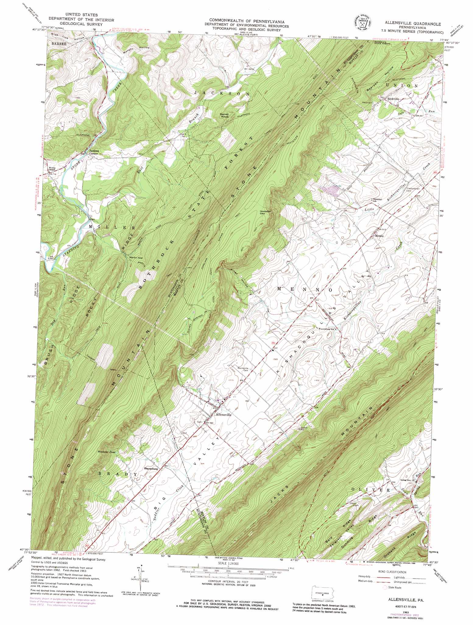
Allensville Topo Map Pennsylvania
To zoom in, hover over the map of Allensville
USGS Topo Quad 40077e7 - 1:24,000 scale
| Topo Map Name: | Allensville |
| USGS Topo Quad ID: | 40077e7 |
| Print Size: | ca. 21 1/4" wide x 27" high |
| Southeast Coordinates: | 40.5° N latitude / 77.75° W longitude |
| Map Center Coordinates: | 40.5625° N latitude / 77.8125° W longitude |
| U.S. State: | PA |
| Filename: | o40077e7.jpg |
| Download Map JPG Image: | Allensville topo map 1:24,000 scale |
| Map Type: | Topographic |
| Topo Series: | 7.5´ |
| Map Scale: | 1:24,000 |
| Source of Map Images: | United States Geological Survey (USGS) |
| Alternate Map Versions: |
Allensville PA 1963, updated 1965 Download PDF Buy paper map Allensville PA 1963, updated 1973 Download PDF Buy paper map Allensville PA 1963, updated 1986 Download PDF Buy paper map Allensville PA 2010 Download PDF Buy paper map Allensville PA 2013 Download PDF Buy paper map Allensville PA 2016 Download PDF Buy paper map |
1:24,000 Topo Quads surrounding Allensville
Port Matilda |
Julian |
State College |
Centre Hall |
Spring Mills |
Franklinville |
Pine Grove Mills |
Mcalevys Fort |
Barrville |
Burnham |
Alexandria |
Donation |
Allensville |
Belleville |
Lewistown |
Huntingdon |
Mount Union |
Newton Hamilton |
Mcveytown |
Mccoysville |
Cassville |
Butler Knob |
Aughwick |
Blairs Mills |
Blain |
> Back to 40077e1 at 1:100,000 scale
> Back to 40076a1 at 1:250,000 scale
> Back to U.S. Topo Maps home
Allensville topo map: Gazetteer
Allensville: Airports
Huey Airport elevation 624m 2047′Allensville: Gaps
Hostetler Gap elevation 454m 1489′Martin Gap elevation 235m 770′
Allensville: Lakes
Westover Pond elevation 374m 1227′Allensville: Populated Places
Allensville elevation 295m 967′Jackson Corner elevation 223m 731′
Menno elevation 285m 935′
Rockville elevation 299m 980′
Sharpsburg elevation 293m 961′
Allensville: Post Offices
Allensville Post Office (historical) elevation 299m 980′Allensville: Ridges
Bald Ridge elevation 331m 1085′Brush Ridge elevation 275m 902′
Dunmire Ridge elevation 289m 948′
Rocky Ridge elevation 353m 1158′
Allensville: Springs
Swarey Spring elevation 260m 853′Allensville: Streams
Dry Run elevation 202m 662′East Branch Standing Stone Creek elevation 207m 679′
Geisler Run elevation 207m 679′
Herod Run elevation 218m 715′
Spring Run elevation 191m 626′
Spruce Run elevation 208m 682′
Allensville: Summits
Garret Knob elevation 334m 1095′Prayer Rock elevation 582m 1909′
Stone Mountain elevation 668m 2191′
Allensville: Trails
Carbon Trail elevation 419m 1374′Chipp Trail elevation 523m 1715′
Copeland Spring Trail elevation 529m 1735′
Eleven Springs Trail elevation 525m 1722′
Hostetler Trail elevation 507m 1663′
Martin Trail elevation 434m 1423′
Rockville Trail elevation 410m 1345′
Allensville: Valleys
Bearpen Hollow elevation 350m 1148′Big Valley elevation 280m 918′
Blue Lick Hollow elevation 220m 721′
Kings Hollow elevation 299m 980′
Murphy Hollow elevation 230m 754′
Allensville digital topo map on disk
Buy this Allensville topo map showing relief, roads, GPS coordinates and other geographical features, as a high-resolution digital map file on DVD:
Atlantic Coast (NY, NJ, PA, DE, MD, VA, NC)
Buy digital topo maps: Atlantic Coast (NY, NJ, PA, DE, MD, VA, NC)
 map DVD")