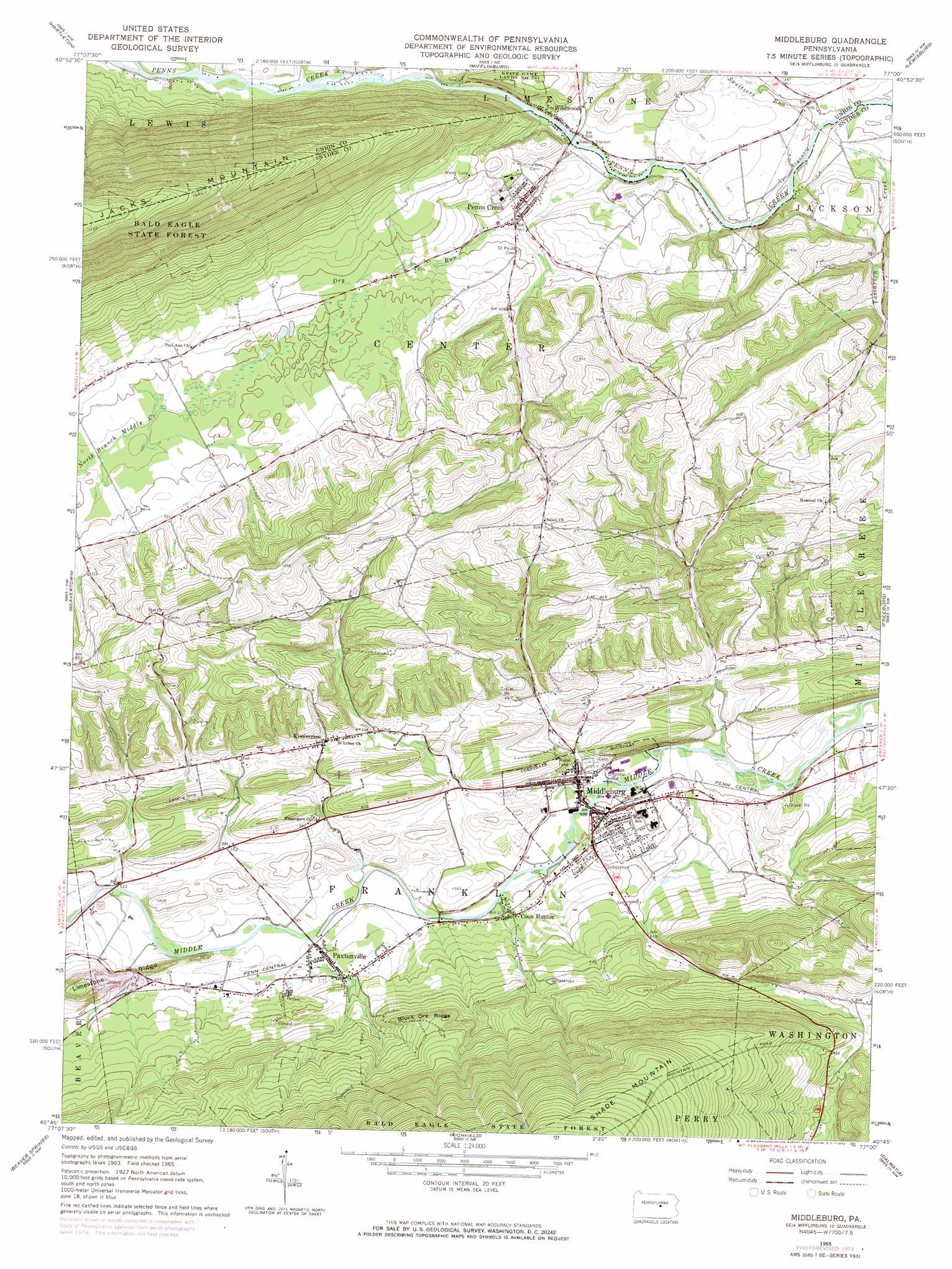
Middleburg Topo Map Pennsylvania
To zoom in, hover over the map of Middleburg
USGS Topo Quad 40077g1 - 1:24,000 scale
| Topo Map Name: | Middleburg |
| USGS Topo Quad ID: | 40077g1 |
| Print Size: | ca. 21 1/4" wide x 27" high |
| Southeast Coordinates: | 40.75° N latitude / 77° W longitude |
| Map Center Coordinates: | 40.8125° N latitude / 77.0625° W longitude |
| U.S. State: | PA |
| Filename: | o40077g1.jpg |
| Download Map JPG Image: | Middleburg topo map 1:24,000 scale |
| Map Type: | Topographic |
| Topo Series: | 7.5´ |
| Map Scale: | 1:24,000 |
| Source of Map Images: | United States Geological Survey (USGS) |
| Alternate Map Versions: |
Middleburg PA 1965, updated 1966 Download PDF Buy paper map Middleburg PA 1965, updated 1973 Download PDF Buy paper map Middleburg PA 1965, updated 1973 Download PDF Buy paper map Middleburg PA 2010 Download PDF Buy paper map Middleburg PA 2013 Download PDF Buy paper map Middleburg PA 2016 Download PDF Buy paper map |
1:24,000 Topo Quads surrounding Middleburg
Loganton |
Carroll |
Williamsport Se |
Allenwood |
Milton |
Woodward |
Hartleton |
Mifflinburg |
Lewisburg |
Northumberland |
Weikert |
Beavertown |
Middleburg |
Freeburg |
Sunbury |
Mcclure |
Beaver Springs |
Richfield |
Dalmatia |
Pillow |
Mexico |
Millerstown |
Reward |
Millersburg |
Elizabethville |
> Back to 40077e1 at 1:100,000 scale
> Back to 40076a1 at 1:250,000 scale
> Back to U.S. Topo Maps home
Middleburg topo map: Gazetteer
Middleburg: Airports
Roadcap Airport elevation 222m 728′Middleburg: Parks
Summit Park elevation 290m 951′Middleburg: Populated Places
Coon Hunter elevation 159m 521′Kissimmee elevation 192m 629′
Middleburg elevation 148m 485′
Paxtonville elevation 163m 534′
Penns Creek elevation 171m 561′
Wildwood elevation 164m 538′
Middleburg: Ridges
Block Ore Ridge elevation 273m 895′Limestone Ridge elevation 258m 846′
Middleburg: Streams
Dry Run elevation 158m 518′Sweitzers Run elevation 150m 492′
Tuscarora Creek elevation 150m 492′
Middleburg: Trails
Furnace Trail elevation 253m 830′Middleburg digital topo map on disk
Buy this Middleburg topo map showing relief, roads, GPS coordinates and other geographical features, as a high-resolution digital map file on DVD:
Atlantic Coast (NY, NJ, PA, DE, MD, VA, NC)
Buy digital topo maps: Atlantic Coast (NY, NJ, PA, DE, MD, VA, NC)
 map DVD")