Centre Hall Topo Map Pennsylvania
To zoom in, hover over the map of Centre Hall
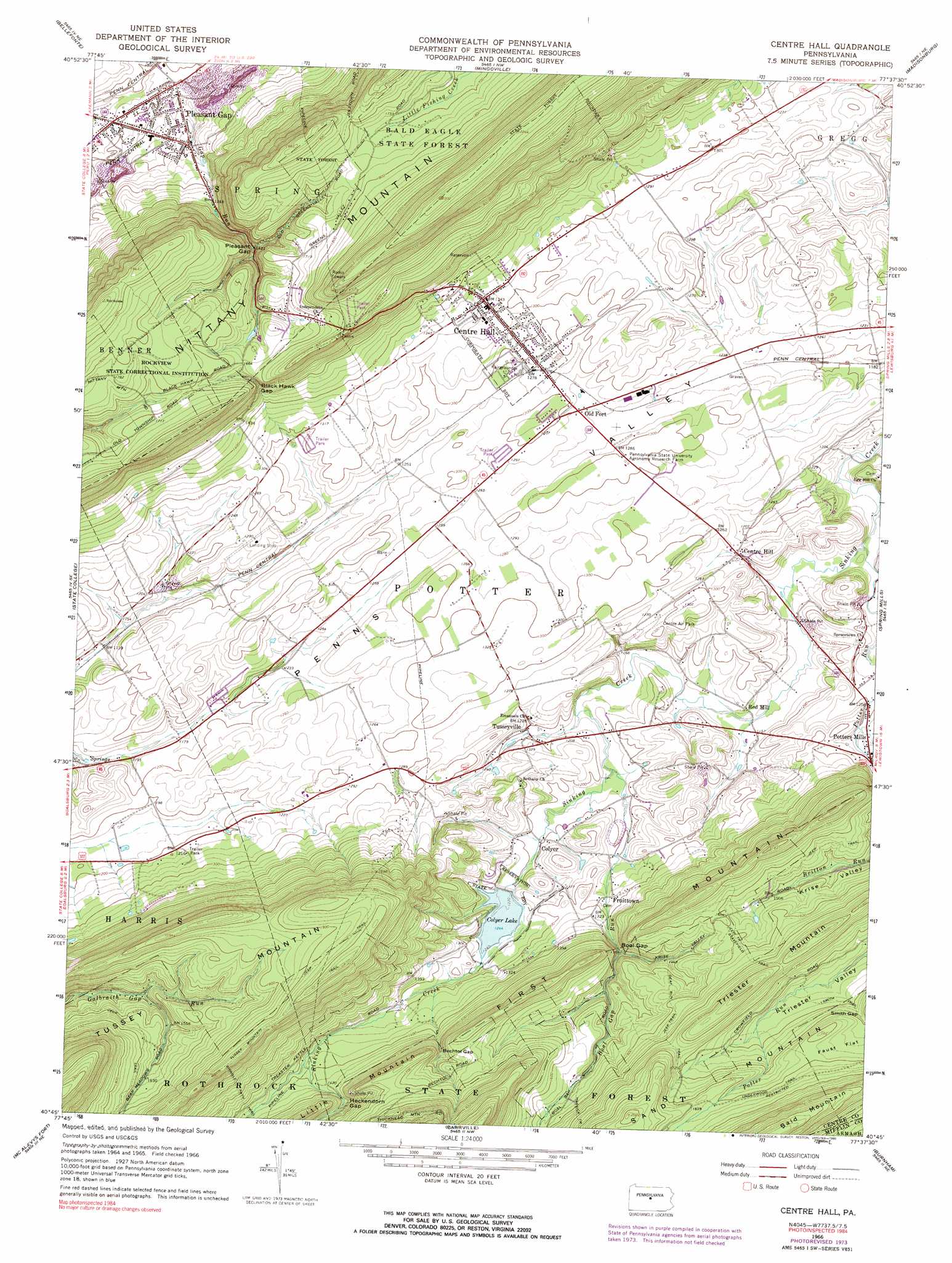
USGS Topo Quad 40077g6 - 1:24,000 scale
| Topo Map Name: | Centre Hall |
| USGS Topo Quad ID: | 40077g6 |
| Print Size: | ca. 21 1/4" wide x 27" high |
| Southeast Coordinates: | 40.75° N latitude / 77.625° W longitude |
| Map Center Coordinates: | 40.8125° N latitude / 77.6875° W longitude |
| U.S. State: | PA |
| Filename: | o40077g6.jpg |
| Download Map JPG Image: | Centre Hall topo map 1:24,000 scale |
| Map Type: | Topographic |
| Topo Series: | 7.5´ |
| Map Scale: | 1:24,000 |
| Source of Map Images: | United States Geological Survey (USGS) |
| Alternate Map Versions: |
Centre Hall PA 1966, updated 1968 Download PDF Buy paper map Centre Hall PA 1966, updated 1973 Download PDF Buy paper map Centre Hall PA 1966, updated 1990 Download PDF Buy paper map Centre Hall PA 1977, updated 1979 Download PDF Buy paper map Centre Hall PA 1998, updated 1999 Download PDF Buy paper map Centre Hall PA 2010 Download PDF Buy paper map Centre Hall PA 2013 Download PDF Buy paper map Centre Hall PA 2016 Download PDF Buy paper map |
1:24,000 Topo Quads surrounding Centre Hall
Snow Shoe |
Snow Shoe Se |
Howard |
Beech Creek |
Mill Hall |
Bear Knob |
Bellefonte |
Mingoville |
Madisonburg |
Millheim |
Julian |
State College |
Centre Hall |
Spring Mills |
Coburn |
Pine Grove Mills |
Mcalevys Fort |
Barrville |
Burnham |
Alfarata |
Donation |
Allensville |
Belleville |
Lewistown |
Mifflintown |
> Back to 40077e1 at 1:100,000 scale
> Back to 40076a1 at 1:250,000 scale
> Back to U.S. Topo Maps home
Centre Hall topo map: Gazetteer
Centre Hall: Airports
Centre Airpark elevation 395m 1295′Garbrick Airport elevation 392m 1286′
Centre Hall: Dams
Colyer Lake Dam elevation 367m 1204′Centre Hall: Flats
Faust Flat elevation 545m 1788′Centre Hall: Gaps
Bechtol Gap elevation 462m 1515′Black Hawk Gap elevation 465m 1525′
Boal Gap elevation 426m 1397′
Heckendorn Gap elevation 447m 1466′
Pleasant Gap elevation 437m 1433′
Smith Gap elevation 509m 1669′
Centre Hall: Populated Places
Centre Hall elevation 404m 1325′Centre Hill elevation 371m 1217′
Colyer elevation 365m 1197′
Fruittown elevation 386m 1266′
Old Fort elevation 385m 1263′
Pleasant Gap elevation 299m 980′
Potters Mills elevation 386m 1266′
Red Mill elevation 354m 1161′
Tusseyville elevation 364m 1194′
Centre Hall: Reservoirs
Colyer Lake elevation 377m 1236′Centre Hall: Streams
Black Hawk Gap Run elevation 372m 1220′Boal Gap Run elevation 353m 1158′
Gap Run elevation 304m 997′
Potter Brook elevation 346m 1135′
Potter Run elevation 341m 1118′
Centre Hall: Summits
Bald Mountain elevation 675m 2214′First Mountain elevation 550m 1804′
Little Mountain elevation 467m 1532′
Triester Mountain elevation 571m 1873′
Centre Hall: Trails
Deaf Run Trail elevation 494m 1620′Smith Trail elevation 479m 1571′
Stavefield Trail elevation 506m 1660′
Tussey Mountain Trail elevation 601m 1971′
Underwood Trail elevation 559m 1833′
Centre Hall digital topo map on disk
Buy this Centre Hall topo map showing relief, roads, GPS coordinates and other geographical features, as a high-resolution digital map file on DVD:
Atlantic Coast (NY, NJ, PA, DE, MD, VA, NC)
Buy digital topo maps: Atlantic Coast (NY, NJ, PA, DE, MD, VA, NC)
 map DVD")