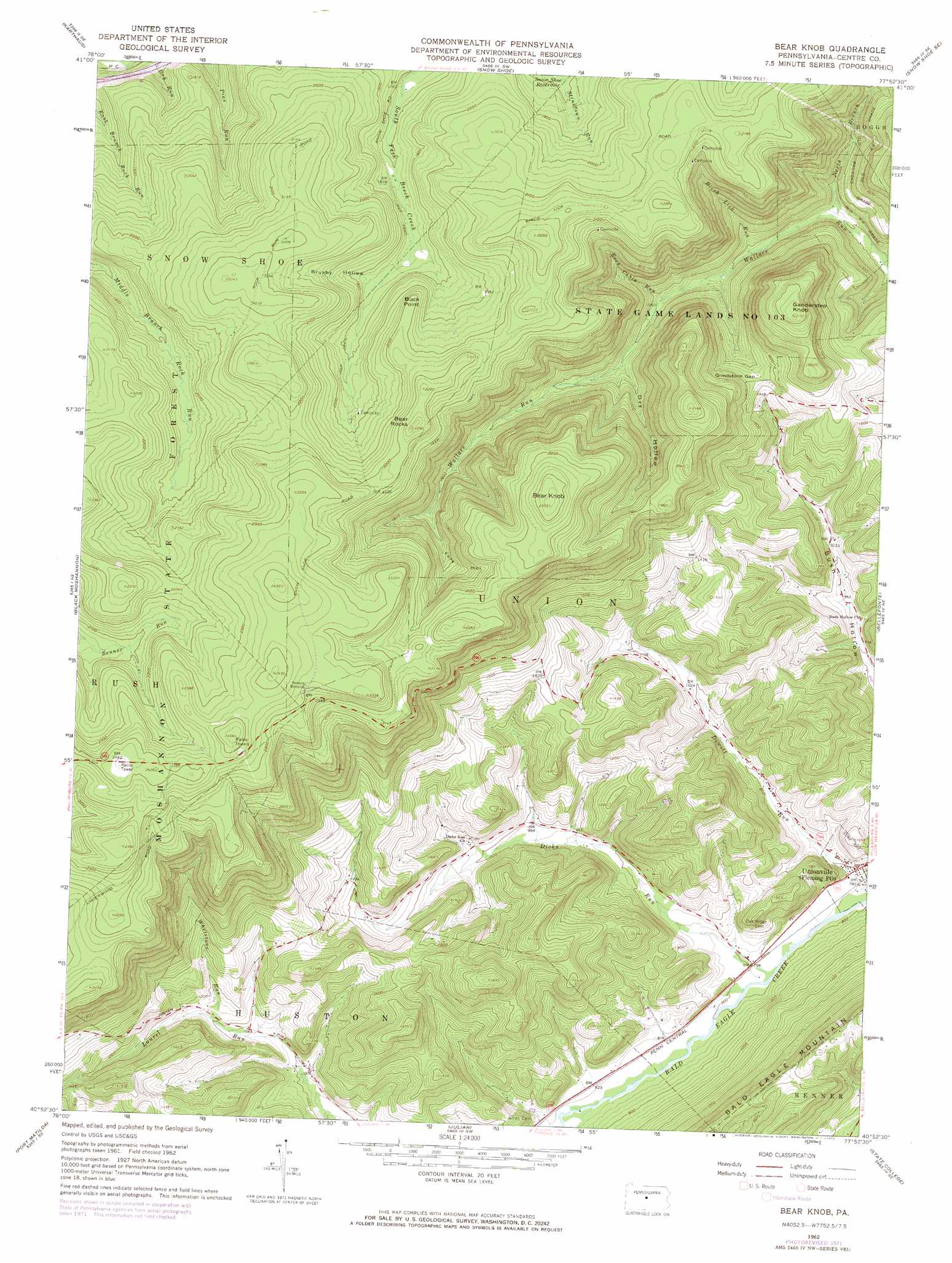
Bear Knob Topo Map Pennsylvania
To zoom in, hover over the map of Bear Knob
USGS Topo Quad 40077h8 - 1:24,000 scale
| Topo Map Name: | Bear Knob |
| USGS Topo Quad ID: | 40077h8 |
| Print Size: | ca. 21 1/4" wide x 27" high |
| Southeast Coordinates: | 40.875° N latitude / 77.875° W longitude |
| Map Center Coordinates: | 40.9375° N latitude / 77.9375° W longitude |
| U.S. State: | PA |
| Filename: | o40077h8.jpg |
| Download Map JPG Image: | Bear Knob topo map 1:24,000 scale |
| Map Type: | Topographic |
| Topo Series: | 7.5´ |
| Map Scale: | 1:24,000 |
| Source of Map Images: | United States Geological Survey (USGS) |
| Alternate Map Versions: |
Bear Knob PA 1962, updated 1964 Download PDF Buy paper map Bear Knob PA 1962, updated 1972 Download PDF Buy paper map Bear Knob PA 1998, updated 1999 Download PDF Buy paper map Bear Knob PA 2010 Download PDF Buy paper map Bear Knob PA 2013 Download PDF Buy paper map Bear Knob PA 2016 Download PDF Buy paper map |
1:24,000 Topo Quads surrounding Bear Knob
Devils Elbow |
Pottersdale |
Snow Shoe Nw |
Snow Shoe Ne |
Howard Nw |
Frenchville |
Karthaus |
Snow Shoe |
Snow Shoe Se |
Howard |
Philipsburg |
Black Moshannon |
Bear Knob |
Bellefonte |
Mingoville |
Sandy Ridge |
Port Matilda |
Julian |
State College |
Centre Hall |
Tyrone |
Franklinville |
Pine Grove Mills |
Mcalevys Fort |
Barrville |
> Back to 40077e1 at 1:100,000 scale
> Back to 40076a1 at 1:250,000 scale
> Back to U.S. Topo Maps home
Bear Knob topo map: Gazetteer
Bear Knob: Airports
Eagle Ridge Gliderport elevation 247m 810′Ridge Soaring Airport elevation 246m 807′
Bear Knob: Cliffs
Buck Point elevation 641m 2103′Bear Knob: Gaps
Grindstone Gap elevation 476m 1561′Bear Knob: Parks
State Game Lands Number 103 elevation 587m 1925′Bear Knob: Populated Places
Unionville elevation 240m 787′Bear Knob: Streams
Birch Lick Run elevation 359m 1177′Dicks Run elevation 241m 790′
North Branch Wallace Run elevation 341m 1118′
Rock Cabin Run elevation 381m 1250′
Whetstone Run elevation 334m 1095′
Bear Knob: Summits
Bear Knob elevation 713m 2339′Bear Rocks elevation 696m 2283′
Ganderstep Knob elevation 658m 2158′
Bear Knob: Valleys
Brushy Hollow elevation 569m 1866′Dry Hollow elevation 407m 1335′
Foxy Hollow elevation 507m 1663′
Bear Knob digital topo map on disk
Buy this Bear Knob topo map showing relief, roads, GPS coordinates and other geographical features, as a high-resolution digital map file on DVD:
Atlantic Coast (NY, NJ, PA, DE, MD, VA, NC)
Buy digital topo maps: Atlantic Coast (NY, NJ, PA, DE, MD, VA, NC)
 map DVD")