Wells Tannery Topo Map Pennsylvania
To zoom in, hover over the map of Wells Tannery
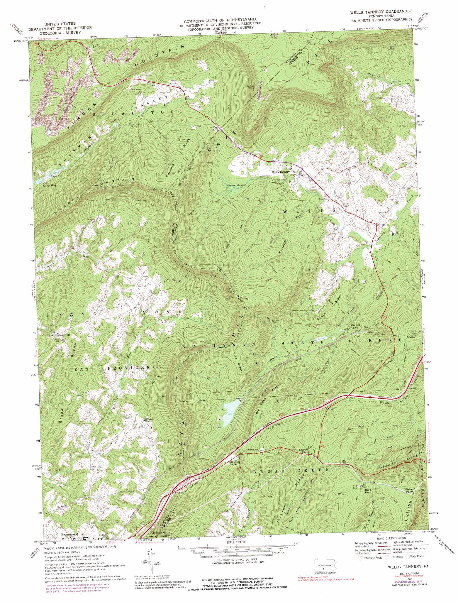
USGS Topo Quad 40078a2 - 1:24,000 scale
| Topo Map Name: | Wells Tannery |
| USGS Topo Quad ID: | 40078a2 |
| Print Size: | ca. 21 1/4" wide x 27" high |
| Southeast Coordinates: | 40° N latitude / 78.125° W longitude |
| Map Center Coordinates: | 40.0625° N latitude / 78.1875° W longitude |
| U.S. State: | PA |
| Filename: | o40078a2.jpg |
| Download Map JPG Image: | Wells Tannery topo map 1:24,000 scale |
| Map Type: | Topographic |
| Topo Series: | 7.5´ |
| Map Scale: | 1:24,000 |
| Source of Map Images: | United States Geological Survey (USGS) |
| Alternate Map Versions: |
Wells Tannery PA 1968, updated 1970 Download PDF Buy paper map Wells Tannery PA 1968, updated 1974 Download PDF Buy paper map Wells Tannery PA 1968, updated 1989 Download PDF Buy paper map Wells Tannery PA 1968, updated 1989 Download PDF Buy paper map Wells Tannery PA 2010 Download PDF Buy paper map Wells Tannery PA 2013 Download PDF Buy paper map Wells Tannery PA 2016 Download PDF Buy paper map |
1:24,000 Topo Quads surrounding Wells Tannery
Roaring Spring |
Martinsburg |
Entriken |
Cassville |
Butler Knob |
New Enterprise |
Hopewell |
Saxton |
Saltillo |
Orbisonia |
Everett West |
Everett East |
Wells Tannery |
Hustontown |
Burnt Cabins |
Clearville |
Mench |
Breezewood |
Meadow Grounds |
Mcconnellsburg |
Chaneysville |
Amaranth |
Needmore |
Big Cove Tannery |
Mercersburg |
> Back to 40078a1 at 1:100,000 scale
> Back to 40078a1 at 1:250,000 scale
> Back to U.S. Topo Maps home
Wells Tannery topo map: Gazetteer
Wells Tannery: Dams
Pa-32 Dam elevation 397m 1302′Wells Tannery: Lakes
Beaverdam Pond elevation 357m 1171′Lake Groundhog elevation 344m 1128′
Wells Tannery: Mines
Garlick Mine elevation 681m 2234′Wells Tannery: Populated Places
Bills Place (historical) elevation 567m 1860′Budds Place elevation 669m 2194′
Graceville elevation 404m 1325′
Jerkwater elevation 373m 1223′
Old Mountain House elevation 533m 1748′
Sandy Run elevation 436m 1430′
Shortys Place elevation 626m 2053′
Valley-Hi elevation 409m 1341′
Wells Tannery elevation 372m 1220′
Wells Tannery: Reservoirs
Valley-Hi Eagle Lake elevation 397m 1302′Wells Tannery: Ridges
Big Wood Ridge elevation 544m 1784′Childers Ridge elevation 571m 1873′
Duvall Ridge elevation 429m 1407′
Grape Ridge elevation 467m 1532′
Jackson Ridge elevation 493m 1617′
Pine Ridge elevation 526m 1725′
Wells Tannery: Streams
Laurel Fork elevation 322m 1056′Meredith Run elevation 340m 1115′
Oregon Creek elevation 323m 1059′
Wells Tannery: Summits
Bald Knob elevation 702m 2303′Fisher Point elevation 701m 2299′
Harbor Mountain elevation 649m 2129′
Kimber Mountain elevation 642m 2106′
Wells Tannery: Swamps
Wishart Swamp elevation 374m 1227′Wells Tannery: Trails
Big Fill Trail elevation 400m 1312′Childers Ridge Trail elevation 486m 1594′
Cornelius Trail elevation 611m 2004′
Duvall Trail elevation 396m 1299′
Horton Jeep Trail elevation 499m 1637′
Huckleberry Trail elevation 521m 1709′
Jerry Trail elevation 604m 1981′
Laidig Spring Trail elevation 604m 1981′
Meredith Trail elevation 427m 1400′
Moseby Trail elevation 421m 1381′
Prop Trail elevation 487m 1597′
Red Bank Trail elevation 406m 1332′
Snowfield Trail elevation 389m 1276′
Sproat Trail elevation 543m 1781′
Tower Trail elevation 651m 2135′
Waterflat Trail elevation 508m 1666′
Wells Tannery: Tunnels
Rays Hill Tunnel elevation 598m 1961′Sideling Hill Tunnel elevation 575m 1886′
Wells Tannery digital topo map on disk
Buy this Wells Tannery topo map showing relief, roads, GPS coordinates and other geographical features, as a high-resolution digital map file on DVD:
 map DVD")