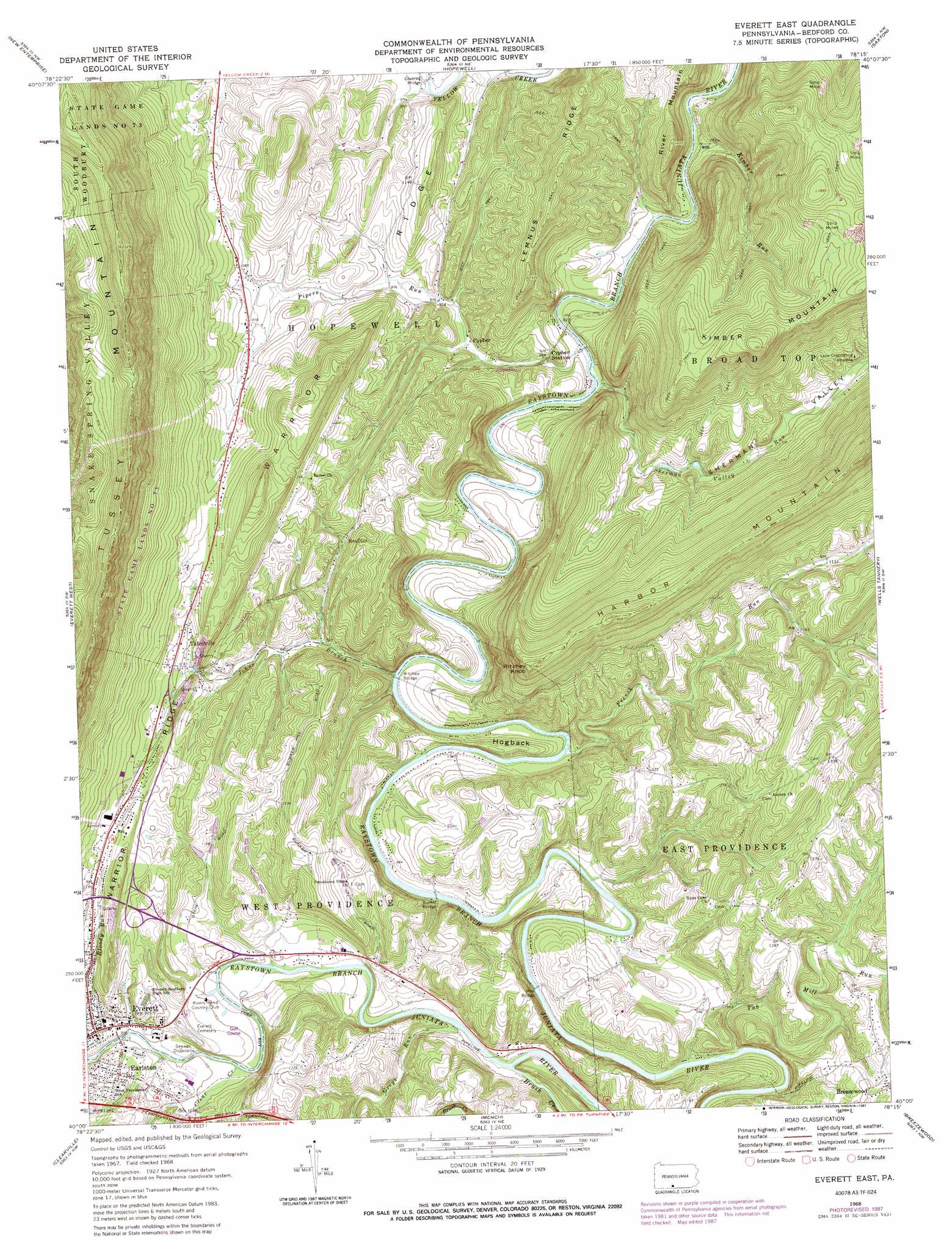
Everett East Topo Map Pennsylvania
To zoom in, hover over the map of Everett East
USGS Topo Quad 40078a3 - 1:24,000 scale
| Topo Map Name: | Everett East |
| USGS Topo Quad ID: | 40078a3 |
| Print Size: | ca. 21 1/4" wide x 27" high |
| Southeast Coordinates: | 40° N latitude / 78.25° W longitude |
| Map Center Coordinates: | 40.0625° N latitude / 78.3125° W longitude |
| U.S. State: | PA |
| Filename: | o40078a3.jpg |
| Download Map JPG Image: | Everett East topo map 1:24,000 scale |
| Map Type: | Topographic |
| Topo Series: | 7.5´ |
| Map Scale: | 1:24,000 |
| Source of Map Images: | United States Geological Survey (USGS) |
| Alternate Map Versions: |
Everett East PA 1968, updated 1970 Download PDF Buy paper map Everett East PA 1968, updated 1974 Download PDF Buy paper map Everett East PA 1968, updated 1984 Download PDF Buy paper map Everett East PA 1968, updated 1987 Download PDF Buy paper map Everett East PA 1994, updated 1997 Download PDF Buy paper map Everett East PA 2010 Download PDF Buy paper map Everett East PA 2013 Download PDF Buy paper map Everett East PA 2016 Download PDF Buy paper map |
1:24,000 Topo Quads surrounding Everett East
Blue Knob |
Roaring Spring |
Martinsburg |
Entriken |
Cassville |
Alum Bank |
New Enterprise |
Hopewell |
Saxton |
Saltillo |
Bedford |
Everett West |
Everett East |
Wells Tannery |
Hustontown |
Rainsburg |
Clearville |
Mench |
Breezewood |
Meadow Grounds |
Beans Cove |
Chaneysville |
Amaranth |
Needmore |
Big Cove Tannery |
> Back to 40078a1 at 1:100,000 scale
> Back to 40078a1 at 1:250,000 scale
> Back to U.S. Topo Maps home
Everett East topo map: Gazetteer
Everett East: Bridges
Hall's Mill Covered Bridge elevation 282m 925′Ritchey Bridge elevation 286m 938′
Woy Bridge elevation 295m 967′
Everett East: Parks
State Game Lands Number 261 elevation 438m 1437′State Game Lands Number 73 elevation 594m 1948′
Everett East: Populated Places
Brallier elevation 353m 1158′Cypher elevation 295m 967′
Earlston elevation 331m 1085′
Everett elevation 308m 1010′
Tatesville elevation 343m 1125′
Everett East: Ridges
Hogback elevation 312m 1023′Lemnus Ridge elevation 451m 1479′
Everett East: Streams
Bloody Run elevation 301m 987′Brush Creek elevation 300m 984′
Clear Creek elevation 308m 1010′
French Run elevation 291m 954′
Greys Run elevation 297m 974′
Johns Branch elevation 292m 958′
Kimber Run elevation 274m 898′
Pipers Run elevation 266m 872′
Sherman Valley Run elevation 279m 915′
Tub Mill Run elevation 318m 1043′
Everett East: Summits
Ritchey Knob elevation 551m 1807′Everett East: Valleys
Sherman Valley elevation 294m 964′Everett East digital topo map on disk
Buy this Everett East topo map showing relief, roads, GPS coordinates and other geographical features, as a high-resolution digital map file on DVD:
 map DVD")