Geistown Topo Map Pennsylvania
To zoom in, hover over the map of Geistown
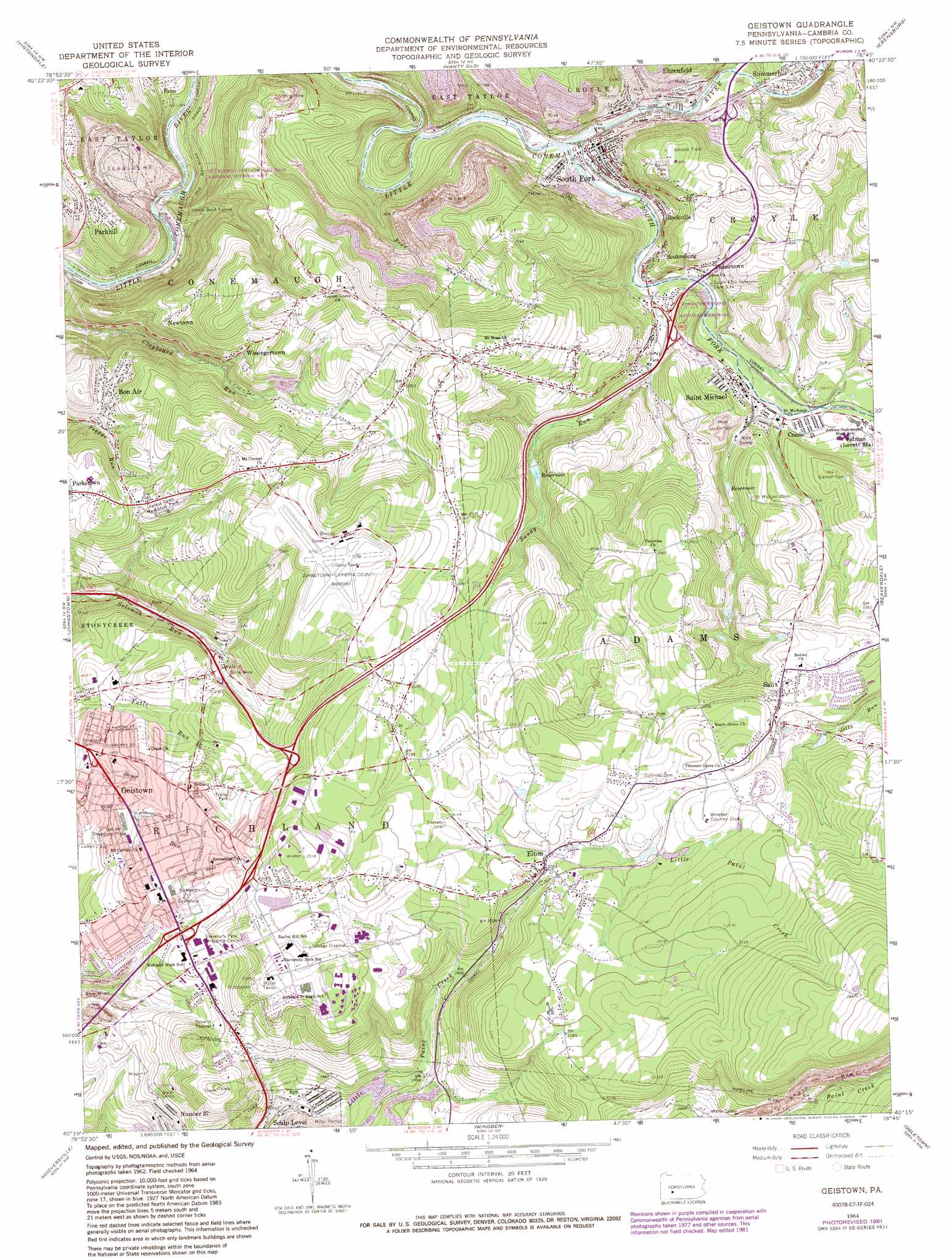
USGS Topo Quad 40078c7 - 1:24,000 scale
| Topo Map Name: | Geistown |
| USGS Topo Quad ID: | 40078c7 |
| Print Size: | ca. 21 1/4" wide x 27" high |
| Southeast Coordinates: | 40.25° N latitude / 78.75° W longitude |
| Map Center Coordinates: | 40.3125° N latitude / 78.8125° W longitude |
| U.S. State: | PA |
| Filename: | o40078c7.jpg |
| Download Map JPG Image: | Geistown topo map 1:24,000 scale |
| Map Type: | Topographic |
| Topo Series: | 7.5´ |
| Map Scale: | 1:24,000 |
| Source of Map Images: | United States Geological Survey (USGS) |
| Alternate Map Versions: |
Geistown PA 1964, updated 1965 Download PDF Buy paper map Geistown PA 1964, updated 1973 Download PDF Buy paper map Geistown PA 1964, updated 1982 Download PDF Buy paper map Geistown PA 1964, updated 1988 Download PDF Buy paper map Geistown PA 1964, updated 1988 Download PDF Buy paper map Geistown PA 1993, updated 1999 Download PDF Buy paper map Geistown PA 2010 Download PDF Buy paper map Geistown PA 2013 Download PDF Buy paper map Geistown PA 2016 Download PDF Buy paper map |
1:24,000 Topo Quads surrounding Geistown
Brush Valley |
Strongstown |
Colver |
Carrolltown |
Ashville |
New Florence |
Vintondale |
Nanty Glo |
Ebensburg |
Cresson |
Rachelwood |
Johnstown |
Geistown |
Beaverdale |
Blue Knob |
Boswell |
Hooversville |
Windber |
Ogletown |
Alum Bank |
Somerset |
Stoystown |
Central City |
Schellsburg |
Bedford |
> Back to 40078a1 at 1:100,000 scale
> Back to 40078a1 at 1:250,000 scale
> Back to U.S. Topo Maps home
Geistown topo map: Gazetteer
Geistown: Airports
Arabian Farm Airport elevation 661m 2168′Johnstown-Cambria County Airport elevation 695m 2280′
Geistown: Dams
South Fork Reservoir Dam Site elevation 470m 1541′Geistown: Falls
White Tail Falls elevation 485m 1591′Winding Staircase Falls elevation 498m 1633′
Geistown: Lakes
Conemaugh Lake elevation 477m 1564′Geistown: Parks
Allegheny Portage Railroad National Historic Site elevation 527m 1729′Johnstown Flood National Memorial elevation 514m 1686′
Liberty Park elevation 491m 1610′
Geistown: Populated Places
Bon Air elevation 558m 1830′Creslo elevation 484m 1587′
Ehrenfeld elevation 466m 1528′
Elton elevation 623m 2043′
Fishertown elevation 503m 1650′
Geistown elevation 577m 1893′
Newtown elevation 575m 1886′
Number Thirty-Seven elevation 570m 1870′
Parkhill elevation 472m 1548′
Rockville elevation 483m 1584′
Saint Michael elevation 487m 1597′
Salix elevation 625m 2050′
Soukesburg elevation 486m 1594′
South Fork elevation 454m 1489′
Wissingertown elevation 580m 1902′
Geistown: Post Offices
Elton Post Office (historical) elevation 623m 2043′Sidman Post Office (historical) elevation 497m 1630′
Geistown: Streams
Bear Run elevation 430m 1410′Falls Run elevation 446m 1463′
Laurel Run elevation 464m 1522′
Laurel Run elevation 484m 1587′
Laurel Run elevation 467m 1532′
Sandy Run elevation 467m 1532′
South Fork Little Conemaugh River elevation 446m 1463′
Geistown: Tunnels
Staple Bend Tunnel elevation 486m 1594′Geistown digital topo map on disk
Buy this Geistown topo map showing relief, roads, GPS coordinates and other geographical features, as a high-resolution digital map file on DVD:
 map DVD")