Altoona Topo Map Pennsylvania
To zoom in, hover over the map of Altoona
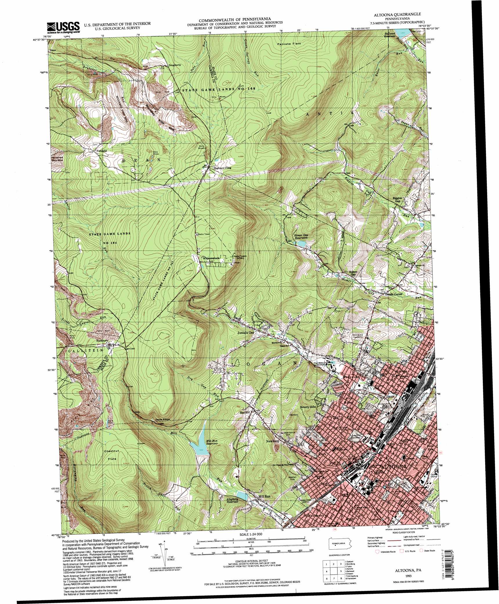
USGS Topo Quad 40078e4 - 1:24,000 scale
| Topo Map Name: | Altoona |
| USGS Topo Quad ID: | 40078e4 |
| Print Size: | ca. 21 1/4" wide x 27" high |
| Southeast Coordinates: | 40.5° N latitude / 78.375° W longitude |
| Map Center Coordinates: | 40.5625° N latitude / 78.4375° W longitude |
| U.S. State: | PA |
| Filename: | o40078e4.jpg |
| Download Map JPG Image: | Altoona topo map 1:24,000 scale |
| Map Type: | Topographic |
| Topo Series: | 7.5´ |
| Map Scale: | 1:24,000 |
| Source of Map Images: | United States Geological Survey (USGS) |
| Alternate Map Versions: |
Altoona PA 1963, updated 1965 Download PDF Buy paper map Altoona PA 1963, updated 1972 Download PDF Buy paper map Altoona PA 1963, updated 1973 Download PDF Buy paper map Altoona PA 1963, updated 1982 Download PDF Buy paper map Altoona PA 1963, updated 1990 Download PDF Buy paper map Altoona PA 1963, updated 1993 Download PDF Buy paper map Altoona PA 1993, updated 1998 Download PDF Buy paper map Altoona PA 2010 Download PDF Buy paper map Altoona PA 2013 Download PDF Buy paper map Altoona PA 2016 Download PDF Buy paper map |
1:24,000 Topo Quads surrounding Altoona
Westover |
Irvona |
Ramey |
Houtzdale |
Sandy Ridge |
Hastings |
Coalport |
Blandburg |
Tipton |
Tyrone |
Carrolltown |
Ashville |
Altoona |
Bellwood |
Spruce Creek |
Ebensburg |
Cresson |
Hollidaysburg |
Frankstown |
Williamsburg |
Beaverdale |
Blue Knob |
Roaring Spring |
Martinsburg |
Entriken |
> Back to 40078e1 at 1:100,000 scale
> Back to 40078a1 at 1:250,000 scale
> Back to U.S. Topo Maps home
Altoona topo map: Gazetteer
Altoona: Cliffs
Devils Elbow elevation 716m 2349′Altoona: Dams
Altoona Lower Number Two Dam elevation 440m 1443′Mill Run Dam elevation 446m 1463′
Storage Dam elevation 398m 1305′
Altoona: Flats
Pancake Flats elevation 726m 2381′Altoona: Parks
Fairview Park elevation 377m 1236′Fairview Park elevation 378m 1240′
Geesey Park elevation 389m 1276′
Gospel Hill Park elevation 400m 1312′
Memorial Park elevation 358m 1174′
Prospect Park elevation 397m 1302′
State Game Lands Number 184 elevation 623m 2043′
State Game Lands Number 267 elevation 784m 2572′
Westfall Park elevation 414m 1358′
Altoona: Populated Places
Alta Manor elevation 376m 1233′Altoona elevation 355m 1164′
Beverly Hills elevation 449m 1473′
Buckhorn elevation 727m 2385′
Calvert Hills elevation 408m 1338′
Dougherty elevation 709m 2326′
East End elevation 367m 1204′
Fairview elevation 394m 1292′
Highland Fling elevation 767m 2516′
Homer Gap elevation 400m 1312′
Juniata elevation 359m 1177′
Juniata Gap elevation 433m 1420′
Mill Run elevation 396m 1299′
Newburg elevation 428m 1404′
Orners Corner elevation 367m 1204′
Pleasant Valley elevation 343m 1125′
Richland elevation 676m 2217′
Riggles Gap elevation 368m 1207′
Wehnwood elevation 368m 1207′
Westmont elevation 359m 1177′
Wopsononock elevation 756m 2480′
Altoona: Reservoirs
Allegheny Reservoir elevation 398m 1305′Bellwood Reservoir elevation 409m 1341′
Homer Gap Reservoir elevation 440m 1443′
Mill Run Reservoir elevation 462m 1515′
Oakton Reservoir elevation 429m 1407′
Altoona: Streams
Dry Gap Run elevation 461m 1512′Kelso Run elevation 391m 1282′
Kettle Creek elevation 341m 1118′
Kittanning Run elevation 490m 1607′
Spring Run elevation 347m 1138′
Spring Run elevation 352m 1154′
Altoona: Summits
Chestnut Flats elevation 729m 2391′Red Hill elevation 511m 1676′
Altoona digital topo map on disk
Buy this Altoona topo map showing relief, roads, GPS coordinates and other geographical features, as a high-resolution digital map file on DVD:
 map DVD")