Philipsburg Topo Map Pennsylvania
To zoom in, hover over the map of Philipsburg
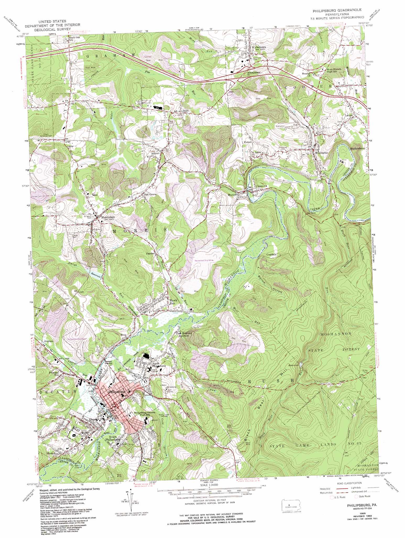
USGS Topo Quad 40078h2 - 1:24,000 scale
| Topo Map Name: | Philipsburg |
| USGS Topo Quad ID: | 40078h2 |
| Print Size: | ca. 21 1/4" wide x 27" high |
| Southeast Coordinates: | 40.875° N latitude / 78.125° W longitude |
| Map Center Coordinates: | 40.9375° N latitude / 78.1875° W longitude |
| U.S. State: | PA |
| Filename: | o40078h2.jpg |
| Download Map JPG Image: | Philipsburg topo map 1:24,000 scale |
| Map Type: | Topographic |
| Topo Series: | 7.5´ |
| Map Scale: | 1:24,000 |
| Source of Map Images: | United States Geological Survey (USGS) |
| Alternate Map Versions: |
Philipsburg PA 1959 Download PDF Buy paper map Philipsburg PA 1959, updated 1960 Download PDF Buy paper map Philipsburg PA 1959, updated 1972 Download PDF Buy paper map Philipsburg PA 1959, updated 1982 Download PDF Buy paper map Philipsburg PA 1959, updated 1993 Download PDF Buy paper map Philipsburg PA 1994, updated 1997 Download PDF Buy paper map Philipsburg PA 2010 Download PDF Buy paper map Philipsburg PA 2013 Download PDF Buy paper map Philipsburg PA 2016 Download PDF Buy paper map |
1:24,000 Topo Quads surrounding Philipsburg
Huntley |
The Knobs |
Devils Elbow |
Pottersdale |
Snow Shoe Nw |
Clearfield |
Lecontes Mills |
Frenchville |
Karthaus |
Snow Shoe |
Glen Richey |
Wallaceton |
Philipsburg |
Black Moshannon |
Bear Knob |
Ramey |
Houtzdale |
Sandy Ridge |
Port Matilda |
Julian |
Blandburg |
Tipton |
Tyrone |
Franklinville |
Pine Grove Mills |
> Back to 40078e1 at 1:100,000 scale
> Back to 40078a1 at 1:250,000 scale
> Back to U.S. Topo Maps home
Philipsburg topo map: Gazetteer
Philipsburg: Airports
Albert Airport elevation 508m 1666′SJA Heliport elevation 436m 1430′
Philipsburg: Crossings
Interchange 21 elevation 492m 1614′Philipsburg: Dams
Morrisdale Dam elevation 441m 1446′Recreation Dam elevation 440m 1443′
Philipsburg: Mines
Cuba Mine (historical) elevation 449m 1473′Rusnak Mine elevation 468m 1535′
Philipsburg: Parks
State Game Lands Number 78 elevation 492m 1614′Philipsburg: Populated Places
Allport elevation 491m 1610′Casanova elevation 430m 1410′
Chester Hill elevation 447m 1466′
Coaldale elevation 453m 1486′
Cuba Mines elevation 462m 1515′
Graham elevation 438m 1437′
Hawk Run elevation 447m 1466′
Huckenberry elevation 484m 1587′
Hudson elevation 463m 1519′
Kylertown elevation 503m 1650′
Lanse elevation 485m 1591′
Loch Lomond Junction elevation 433m 1420′
Morrisdale elevation 500m 1640′
Munson elevation 434m 1423′
North Philipsburg elevation 448m 1469′
Oak Grove elevation 487m 1597′
Pardee elevation 440m 1443′
Philipsburg elevation 441m 1446′
Pleasant Hill elevation 445m 1459′
South Philipsburg elevation 439m 1440′
Troy elevation 438m 1437′
Winburne elevation 432m 1417′
Philipsburg: Reservoirs
Emigh Lake elevation 441m 1446′Philipsburg: Streams
Black Bear Run elevation 424m 1391′Cold Stream elevation 432m 1417′
Emigh Run elevation 430m 1410′
Flat Run elevation 479m 1571′
Hawk Run elevation 429m 1407′
Laurel Run elevation 432m 1417′
Little Laurel Run elevation 435m 1427′
Onemile Run elevation 431m 1414′
Sulphur Run elevation 420m 1377′
Wolf Run elevation 430m 1410′
Philipsburg: Summits
Black Bear Hill elevation 612m 2007′Philipsburg: Trails
Black Bear Trail elevation 542m 1778′Philipsburg: Valleys
Barlow Hollow elevation 430m 1410′Philipsburg digital topo map on disk
Buy this Philipsburg topo map showing relief, roads, GPS coordinates and other geographical features, as a high-resolution digital map file on DVD:
 map DVD")