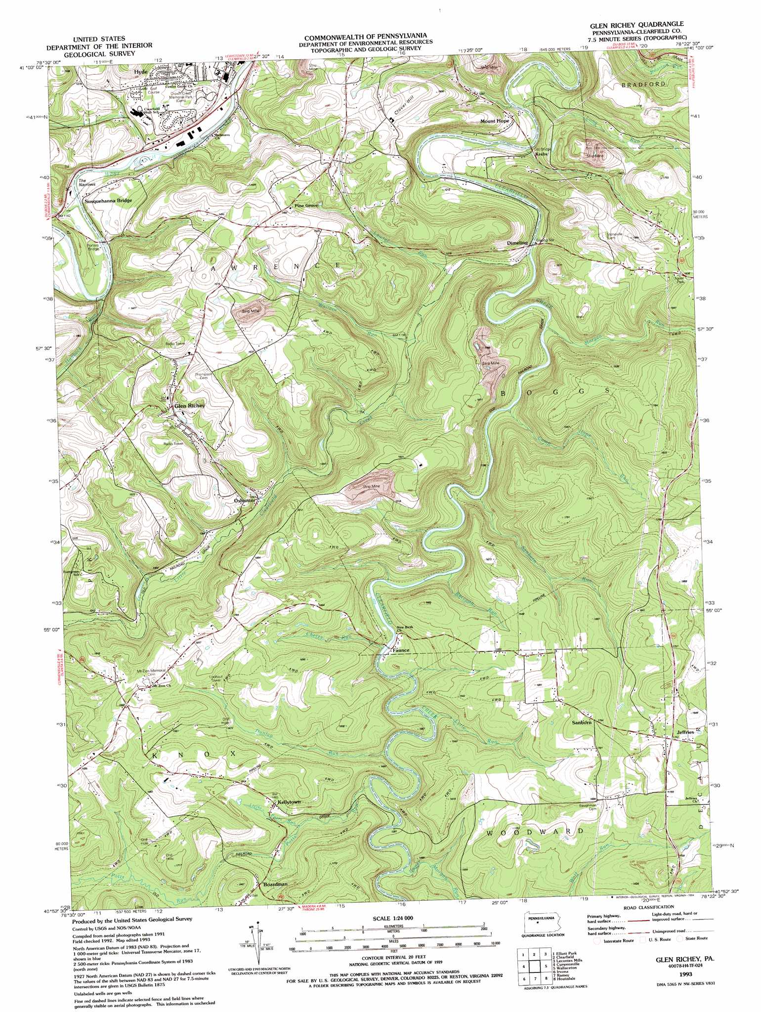
Glen Richey Topo Map Pennsylvania
To zoom in, hover over the map of Glen Richey
USGS Topo Quad 40078h4 - 1:24,000 scale
| Topo Map Name: | Glen Richey |
| USGS Topo Quad ID: | 40078h4 |
| Print Size: | ca. 21 1/4" wide x 27" high |
| Southeast Coordinates: | 40.875° N latitude / 78.375° W longitude |
| Map Center Coordinates: | 40.9375° N latitude / 78.4375° W longitude |
| U.S. State: | PA |
| Filename: | o40078h4.jpg |
| Download Map JPG Image: | Glen Richey topo map 1:24,000 scale |
| Map Type: | Topographic |
| Topo Series: | 7.5´ |
| Map Scale: | 1:24,000 |
| Source of Map Images: | United States Geological Survey (USGS) |
| Alternate Map Versions: |
Glen Richey PA 1944, updated 1956 Download PDF Buy paper map Glen Richey PA 1944, updated 1967 Download PDF Buy paper map Glen Richey PA 1944, updated 1970 Download PDF Buy paper map Glen Richey PA 1944, updated 1982 Download PDF Buy paper map Glen Richey PA 1944, updated 1988 Download PDF Buy paper map Glen Richey PA 1993, updated 1994 Download PDF Buy paper map Glen Richey PA 2010 Download PDF Buy paper map Glen Richey PA 2013 Download PDF Buy paper map Glen Richey PA 2016 Download PDF Buy paper map |
1:24,000 Topo Quads surrounding Glen Richey
Sabula |
Penfield |
Huntley |
The Knobs |
Devils Elbow |
Luthersburg |
Elliott Park |
Clearfield |
Lecontes Mills |
Frenchville |
Mahaffey |
Curwensville |
Glen Richey |
Wallaceton |
Philipsburg |
Westover |
Irvona |
Ramey |
Houtzdale |
Sandy Ridge |
Hastings |
Coalport |
Blandburg |
Tipton |
Tyrone |
> Back to 40078e1 at 1:100,000 scale
> Back to 40078a1 at 1:250,000 scale
> Back to U.S. Topo Maps home
Glen Richey topo map: Gazetteer
Glen Richey: Bridges
Litz Bridge elevation 340m 1115′Porters Bridge elevation 336m 1102′
Glen Richey: Gaps
The Narrows elevation 341m 1118′Glen Richey: Populated Places
Boardman elevation 462m 1515′Faunce elevation 380m 1246′
Glen Richey elevation 424m 1391′
Jeffries elevation 541m 1774′
Kellytown elevation 442m 1450′
Krebs elevation 361m 1184′
Mount Hope elevation 379m 1243′
Oshanter elevation 385m 1263′
Pine Grove elevation 448m 1469′
Sanborn elevation 537m 1761′
Glen Richey: Post Offices
Oshaniter Post Office (historical) elevation 464m 1522′Glen Richey: Streams
Camp Hope Run elevation 362m 1187′Cherry Run elevation 378m 1240′
Dunlap Run elevation 390m 1279′
Hartshorn Run elevation 341m 1118′
Hogback Run elevation 340m 1115′
Laurel Run elevation 358m 1174′
Little Clearfield Creek elevation 353m 1158′
Little Potts Run elevation 408m 1338′
Long Run elevation 346m 1135′
Lytle Run elevation 378m 1240′
Morgan Run elevation 359m 1177′
Potts Run elevation 390m 1279′
Raccoon Run elevation 372m 1220′
Sanborn Run elevation 365m 1197′
Upper Morgan Run elevation 390m 1279′
Wallace Run elevation 363m 1190′
Glen Richey: Summits
Clover Hill elevation 481m 1578′Glen Richey digital topo map on disk
Buy this Glen Richey topo map showing relief, roads, GPS coordinates and other geographical features, as a high-resolution digital map file on DVD:
 map DVD")