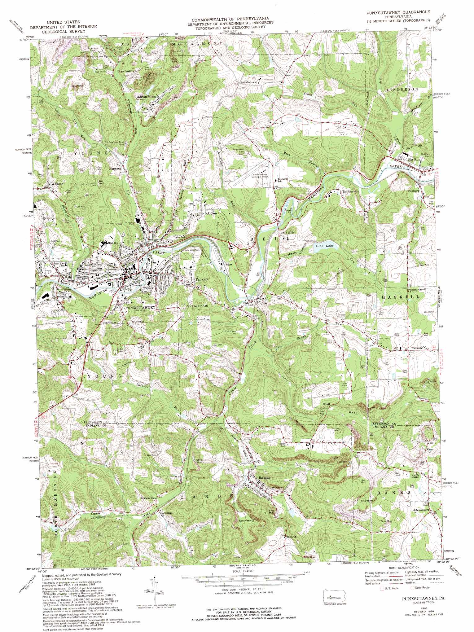
Punxsutawney Topo Map Pennsylvania
To zoom in, hover over the map of Punxsutawney
USGS Topo Quad 40078h8 - 1:24,000 scale
| Topo Map Name: | Punxsutawney |
| USGS Topo Quad ID: | 40078h8 |
| Print Size: | ca. 21 1/4" wide x 27" high |
| Southeast Coordinates: | 40.875° N latitude / 78.875° W longitude |
| Map Center Coordinates: | 40.9375° N latitude / 78.9375° W longitude |
| U.S. State: | PA |
| Filename: | o40078h8.jpg |
| Download Map JPG Image: | Punxsutawney topo map 1:24,000 scale |
| Map Type: | Topographic |
| Topo Series: | 7.5´ |
| Map Scale: | 1:24,000 |
| Source of Map Images: | United States Geological Survey (USGS) |
| Alternate Map Versions: |
Punxsutawney PA 1968, updated 1970 Download PDF Buy paper map Punxsutawney PA 1968, updated 1975 Download PDF Buy paper map Punxsutawney PA 1968, updated 1975 Download PDF Buy paper map Punxsutawney PA 1968, updated 1982 Download PDF Buy paper map Punxsutawney PA 1968, updated 1989 Download PDF Buy paper map Punxsutawney PA 1968, updated 1994 Download PDF Buy paper map Punxsutawney PA 2010 Download PDF Buy paper map Punxsutawney PA 2013 Download PDF Buy paper map Punxsutawney PA 2016 Download PDF Buy paper map |
1:24,000 Topo Quads surrounding Punxsutawney
Corsica |
Brookville |
Hazen |
Falls Creek |
Sabula |
Summerville |
Coolspring |
Reynoldsville |
Du Bois |
Luthersburg |
Dayton |
Valier |
Punxsutawney |
Mcgees Mills |
Mahaffey |
Plumville |
Marion Center |
Rochester Mills |
Burnside |
Westover |
Ernest |
Clymer |
Commodore |
Barnesboro |
Hastings |
> Back to 40078e1 at 1:100,000 scale
> Back to 40078a1 at 1:250,000 scale
> Back to U.S. Topo Maps home
Punxsutawney topo map: Gazetteer
Punxsutawney: Airports
Punxsutawney Municipal Airport elevation 435m 1427′Punxsutawney: Dams
Cloe Dam elevation 417m 1368′Rossiter Dam elevation 430m 1410′
Punxsutawney: Populated Places
Adrian Mines elevation 437m 1433′Albion elevation 440m 1443′
Bells Mills elevation 398m 1305′
Big Run elevation 392m 1286′
Cloe elevation 383m 1256′
Crawfordtown elevation 416m 1364′
Elbell elevation 438m 1437′
Fairview elevation 421m 1381′
Foxburg elevation 399m 1309′
Harmony elevation 384m 1259′
Johnsonburg elevation 563m 1847′
Juneau elevation 402m 1318′
Punxsutawney elevation 374m 1227′
Riker elevation 378m 1240′
Robertsville elevation 406m 1332′
Rossiter elevation 432m 1417′
Spindletown elevation 469m 1538′
Walston elevation 407m 1335′
Winslow elevation 522m 1712′
Punxsutawney: Post Offices
Crawfordtown Delancey Post Office (historical) elevation 409m 1341′De Lancey Post Office elevation 437m 1433′
Punxsutawney: Reservoirs
Cloe Lake elevation 421m 1381′Punxsutawney: Streams
Big Run elevation 389m 1276′Canoe Creek elevation 378m 1240′
Cold Spring Run elevation 377m 1236′
Couch Run elevation 390m 1279′
Elk Run elevation 373m 1223′
Graffius Run elevation 379m 1243′
Jackson Run elevation 384m 1259′
Little Elk Run elevation 394m 1292′
Painter Run elevation 393m 1289′
Rock Run elevation 387m 1269′
Sawmill Run elevation 371m 1217′
Smith Run elevation 406m 1332′
Trout Run elevation 390m 1279′
Ugly Run elevation 384m 1259′
Windfall Run elevation 395m 1295′
Punxsutawney: Summits
Gobblers Knob elevation 495m 1624′Punxsutawney digital topo map on disk
Buy this Punxsutawney topo map showing relief, roads, GPS coordinates and other geographical features, as a high-resolution digital map file on DVD:
 map DVD")