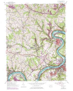
California Topo Map Pennsylvania
To zoom in, hover over the map of California
USGS Topo Quad 40079a8 - 1:24,000 scale
| Topo Map Name: | California |
| USGS Topo Quad ID: | 40079a8 |
| Print Size: | ca. 21 1/4" wide x 27" high |
| Southeast Coordinates: | 40° N latitude / 79.875° W longitude |
| Map Center Coordinates: | 40.0625° N latitude / 79.9375° W longitude |
| U.S. State: | PA |
| Filename: | o40079a8.jpg |
| Download Map JPG Image: | California topo map 1:24,000 scale |
| Map Type: | Topographic |
| Topo Series: | 7.5´ |
| Map Scale: | 1:24,000 |
| Source of Map Images: | United States Geological Survey (USGS) |
| Alternate Map Versions: |
California PA 1954, updated 1955 Download PDF Buy paper map California PA 1954, updated 1970 Download PDF Buy paper map California PA 1954, updated 1979 Download PDF Buy paper map California PA 2010 Download PDF Buy paper map California PA 2013 Download PDF Buy paper map California PA 2016 Download PDF Buy paper map |
1:24,000 Topo Quads surrounding California
> Back to 40079a1 at 1:100,000 scale
> Back to 40078a1 at 1:250,000 scale
> Back to U.S. Topo Maps home
California topo map: Gazetteer
California: Bends
Greenfield Bend elevation 236m 774′California: Dams
Maxwell Lock elevation 226m 741′Maxwell Lock and Dam elevation 257m 843′
California: Lakes
Twin Lakes elevation 347m 1138′California: Mines
Pike Mine elevation 238m 780′California: Populated Places
Alica elevation 242m 793′Binnstown elevation 280m 918′
Blainsburg elevation 243m 797′
Brownsville elevation 258m 846′
California elevation 240m 787′
Centerville elevation 359m 1177′
Century elevation 280m 918′
Clover Hill elevation 374m 1227′
Coal Center elevation 250m 820′
Crescent Heights elevation 310m 1017′
Daisytown elevation 264m 866′
Denbeau Heights elevation 279m 915′
Denbo elevation 241m 790′
Dutch Hill elevation 289m 948′
East Fredricktown elevation 244m 800′
Fredericktown elevation 241m 790′
Granville elevation 243m 797′
Hiller elevation 312m 1023′
Knoxville elevation 356m 1167′
La Belle elevation 307m 1007′
Lover elevation 332m 1089′
Lowhill elevation 297m 974′
Malden Place elevation 364m 1194′
Maple Glen elevation 238m 780′
Marchandville elevation 254m 833′
Maxwell elevation 236m 774′
Moffitts Mills elevation 297m 974′
Newell elevation 236m 774′
Philipsburg elevation 238m 780′
Sharrertown elevation 293m 961′
Smallwood elevation 244m 800′
Speers elevation 240m 787′
Twilight elevation 273m 895′
Vesta Heights elevation 294m 964′
Vesta Number Six elevation 240m 787′
Vestaburg elevation 290m 951′
Walkertown elevation 269m 882′
West Brownsville elevation 234m 767′
Wood Run elevation 243m 797′
California: Reservoirs
Maxwell Pool elevation 257m 843′California: Streams
Barneys Run elevation 233m 764′Dunlap Creek elevation 226m 741′
Fishpot Run elevation 232m 761′
Gorby Run elevation 242m 793′
Lilly Run elevation 226m 741′
Little Pike Run elevation 260m 853′
North Branch Fishpot Run elevation 280m 918′
Pike Run elevation 226m 741′
Redstone Creek elevation 226m 741′
Rush Run elevation 241m 790′
Twomile Run elevation 228m 748′
California: Summits
Krepp Knob elevation 407m 1335′California: Valleys
Granville Hollow elevation 252m 826′Hoods Hollow elevation 264m 866′
Oregon Hollow elevation 252m 826′
Twilight Hollow elevation 244m 800′
Wood Run Hollow elevation 252m 826′
California digital topo map on disk
Buy this California topo map showing relief, roads, GPS coordinates and other geographical features, as a high-resolution digital map file on DVD:


