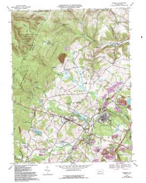
Boswell Topo Map Pennsylvania
To zoom in, hover over the map of Boswell
USGS Topo Quad 40079b1 - 1:24,000 scale
| Topo Map Name: | Boswell |
| USGS Topo Quad ID: | 40079b1 |
| Print Size: | ca. 21 1/4" wide x 27" high |
| Southeast Coordinates: | 40.125° N latitude / 79° W longitude |
| Map Center Coordinates: | 40.1875° N latitude / 79.0625° W longitude |
| U.S. State: | PA |
| Filename: | o40079b1.jpg |
| Download Map JPG Image: | Boswell topo map 1:24,000 scale |
| Map Type: | Topographic |
| Topo Series: | 7.5´ |
| Map Scale: | 1:24,000 |
| Source of Map Images: | United States Geological Survey (USGS) |
| Alternate Map Versions: |
Boswell PA 1967, updated 1971 Download PDF Buy paper map Boswell PA 1967, updated 1973 Download PDF Buy paper map Boswell PA 1967, updated 1982 Download PDF Buy paper map Boswell PA 1967, updated 1988 Download PDF Buy paper map Boswell PA 1967, updated 1993 Download PDF Buy paper map Boswell PA 1977, updated 1979 Download PDF Buy paper map Boswell PA 1997, updated 2000 Download PDF Buy paper map Boswell PA 2010 Download PDF Buy paper map Boswell PA 2013 Download PDF Buy paper map Boswell PA 2016 Download PDF Buy paper map |
1:24,000 Topo Quads surrounding Boswell
> Back to 40079a1 at 1:100,000 scale
> Back to 40078a1 at 1:250,000 scale
> Back to U.S. Topo Maps home
Boswell topo map: Gazetteer
Boswell: Airports
Lohrs Landing Strip elevation 610m 2001′Boswell: Dams
Conemaugh Township Impounding Dam elevation 638m 2093′Gallo Dam elevation 582m 1909′
Jennerstown Dam elevation 675m 2214′
Boswell: Parks
State Game Lands Number 42 elevation 788m 2585′Boswell: Populated Places
Ankeny elevation 571m 1873′Boswell elevation 566m 1856′
Coal Junction elevation 561m 1840′
Ferrellton elevation 556m 1824′
Forwardstown elevation 473m 1551′
Glessner elevation 580m 1902′
Gray elevation 573m 1879′
Jenners elevation 560m 1837′
Jenners Crossroads elevation 587m 1925′
Jennerstown elevation 592m 1942′
Klines Mill elevation 586m 1922′
Meadowdale elevation 560m 1837′
Pilltown elevation 567m 1860′
Randolph elevation 576m 1889′
Thomasdale elevation 455m 1492′
Boswell: Post Offices
Conner Post Office (historical) elevation 579m 1899′Boswell: Ranges
Laurel Hill elevation 862m 2828′Boswell: Reservoirs
Beverly Lake elevation 458m 1502′Boswell Reservoir elevation 621m 2037′
Conemaugh Township Reservoir elevation 622m 2040′
Jennerstown Reservoir elevation 638m 2093′
Lake Gloria elevation 561m 1840′
Rose Bud Lake elevation 560m 1837′
Stoughton Lake elevation 551m 1807′
Boswell: Streams
Beam Run elevation 559m 1833′Beaverdam Creek elevation 553m 1814′
Beaverdam Run elevation 552m 1811′
Card Machine Run elevation 559m 1833′
Coal Run elevation 579m 1899′
Flat Run elevation 567m 1860′
Gum Run elevation 571m 1873′
Hoffman Run elevation 557m 1827′
North Branch Quemahoning Creek elevation 554m 1817′
North Branch South Fork Bens Creek elevation 512m 1679′
Pickings Run elevation 559m 1833′
Pine Run elevation 563m 1847′
Roaring Run elevation 524m 1719′
Spruce Run elevation 558m 1830′
Boswell: Summits
Irwin Hill elevation 868m 2847′Middle Hill elevation 852m 2795′
Mystery Hill elevation 878m 2880′
Pikes Peak elevation 868m 2847′
Pine Hill elevation 842m 2762′
Sugar Camp Hill elevation 887m 2910′
Boswell: Valleys
Bearpen Hollow elevation 707m 2319′Gilbert Hollow elevation 461m 1512′
Boswell digital topo map on disk
Buy this Boswell topo map showing relief, roads, GPS coordinates and other geographical features, as a high-resolution digital map file on DVD:


