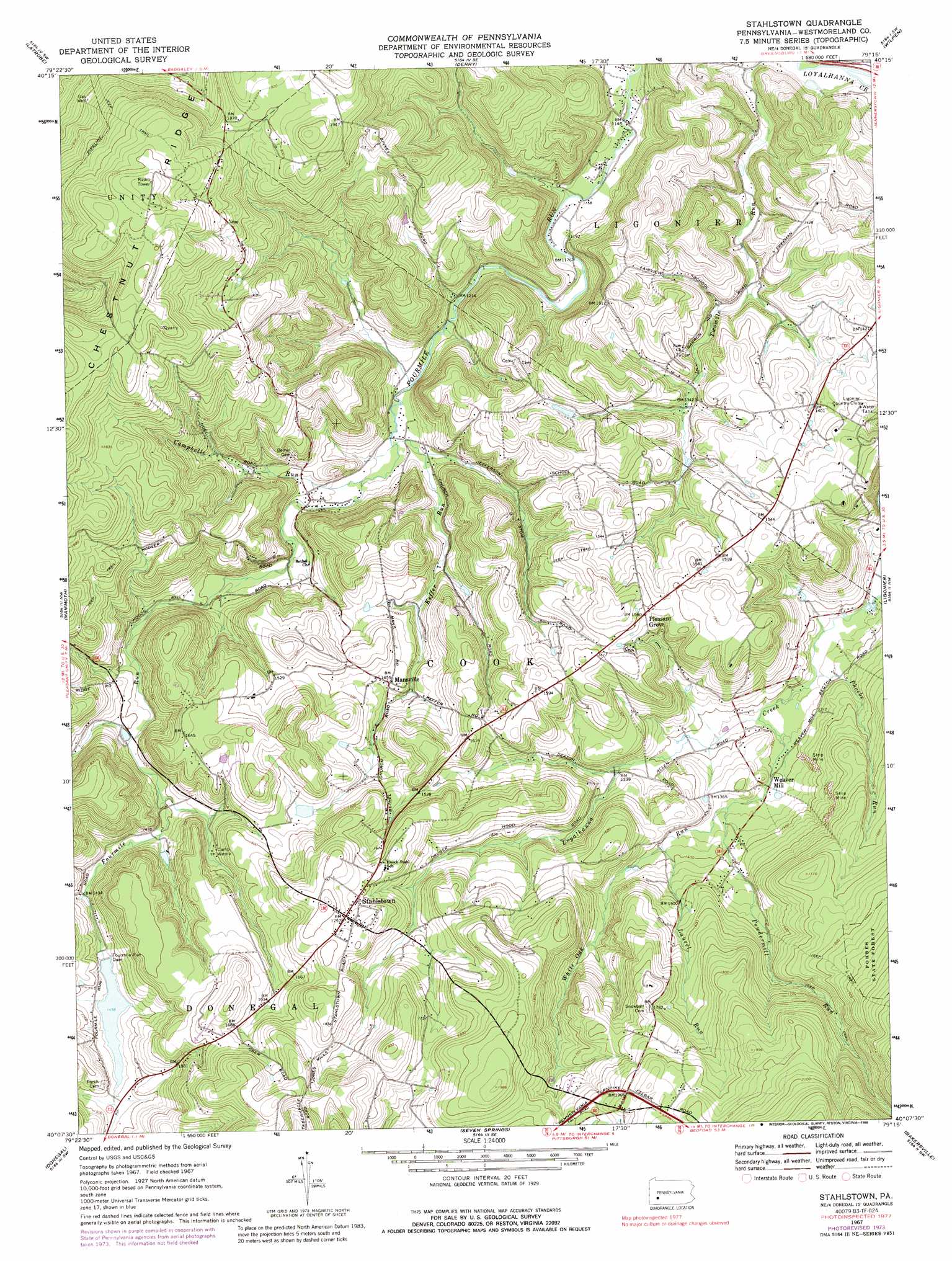
Stahlstown Topo Map Pennsylvania
To zoom in, hover over the map of Stahlstown
USGS Topo Quad 40079b3 - 1:24,000 scale
| Topo Map Name: | Stahlstown |
| USGS Topo Quad ID: | 40079b3 |
| Print Size: | ca. 21 1/4" wide x 27" high |
| Southeast Coordinates: | 40.125° N latitude / 79.25° W longitude |
| Map Center Coordinates: | 40.1875° N latitude / 79.3125° W longitude |
| U.S. State: | PA |
| Filename: | o40079b3.jpg |
| Download Map JPG Image: | Stahlstown topo map 1:24,000 scale |
| Map Type: | Topographic |
| Topo Series: | 7.5´ |
| Map Scale: | 1:24,000 |
| Source of Map Images: | United States Geological Survey (USGS) |
| Alternate Map Versions: |
Stahlstown PA 1967, updated 1970 Download PDF Buy paper map Stahlstown PA 1967, updated 1973 Download PDF Buy paper map Stahlstown PA 1967, updated 1974 Download PDF Buy paper map Stahlstown PA 1967, updated 1984 Download PDF Buy paper map Stahlstown PA 1967, updated 1988 Download PDF Buy paper map Stahlstown PA 2010 Download PDF Buy paper map Stahlstown PA 2013 Download PDF Buy paper map Stahlstown PA 2016 Download PDF Buy paper map |
1:24,000 Topo Quads surrounding Stahlstown
Slickville |
Saltsburg |
Blairsville |
Bolivar |
New Florence |
Greensburg |
Latrobe |
Derry |
Wilpen |
Rachelwood |
Mount Pleasant |
Mammoth |
Stahlstown |
Ligonier |
Boswell |
Connellsville |
Donegal |
Seven Springs |
Bakersville |
Somerset |
South Connellsville |
Mill Run |
Kingwood |
Rockwood |
Murdock |
> Back to 40079a1 at 1:100,000 scale
> Back to 40078a1 at 1:250,000 scale
> Back to U.S. Topo Maps home
Stahlstown topo map: Gazetteer
Stahlstown: Dams
Breskin Dam Number Two elevation 464m 1522′Breskin Pond Dam Number One elevation 451m 1479′
Four Mile Run Dam elevation 444m 1456′
Fourmile Run Dam elevation 444m 1456′
Stahlstown: Populated Places
Mansville elevation 440m 1443′Pleasant Grove elevation 480m 1574′
Stahlstown elevation 535m 1755′
Stahlstown: Reservoirs
Breskin Pond elevation 451m 1479′Stahlstown: Ridges
Chestnut Ridge elevation 648m 2125′Stahlstown: Streams
Campbelle Run elevation 372m 1220′Keffer Run elevation 368m 1207′
Laurel Run elevation 419m 1374′
Mill Creek elevation 346m 1135′
Phoebe Run elevation 383m 1256′
Powdermill Run elevation 407m 1335′
White Oak Run elevation 387m 1269′
Stahlstown digital topo map on disk
Buy this Stahlstown topo map showing relief, roads, GPS coordinates and other geographical features, as a high-resolution digital map file on DVD:
 map DVD")