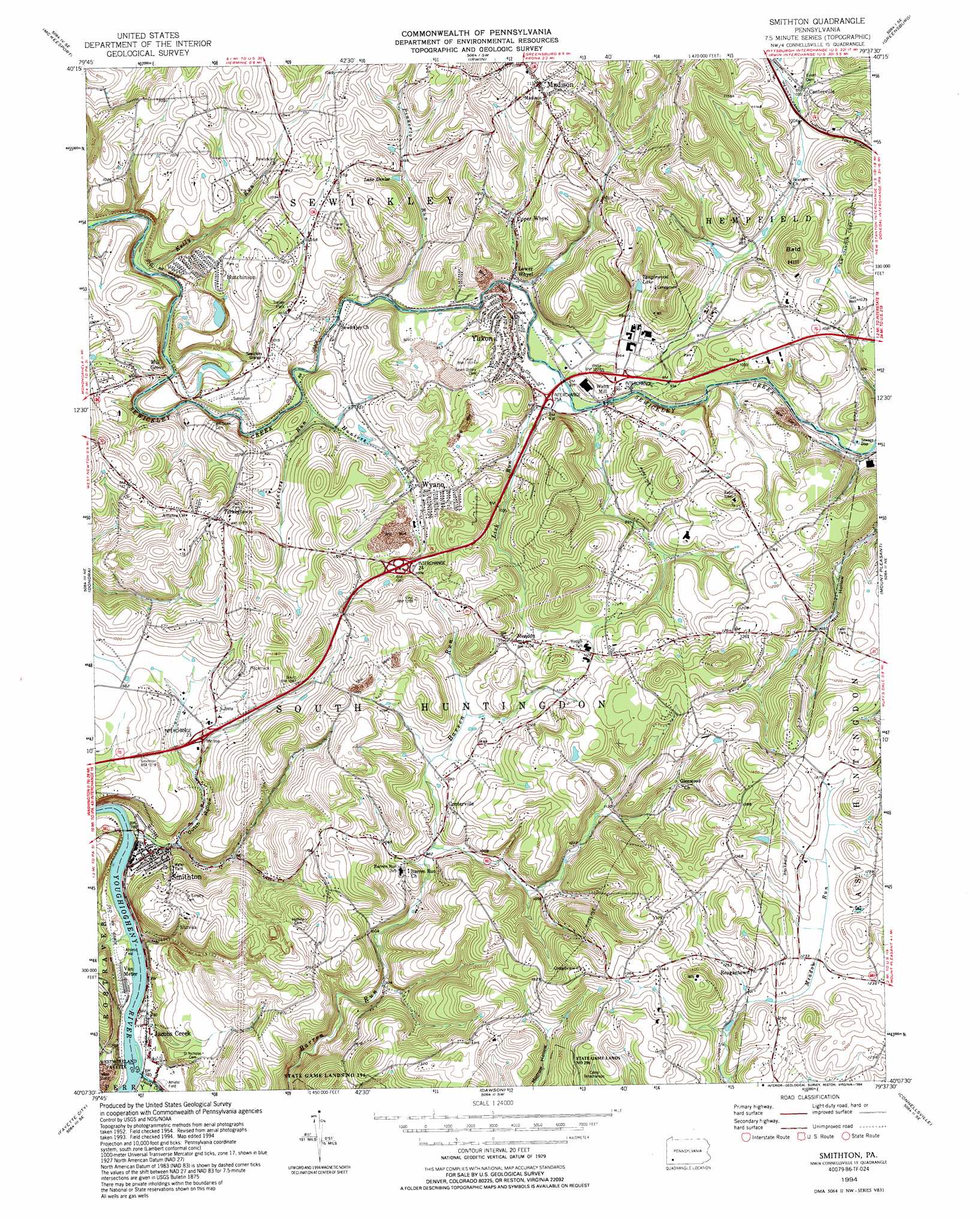
Smithton Topo Map Pennsylvania
To zoom in, hover over the map of Smithton
USGS Topo Quad 40079b6 - 1:24,000 scale
| Topo Map Name: | Smithton |
| USGS Topo Quad ID: | 40079b6 |
| Print Size: | ca. 21 1/4" wide x 27" high |
| Southeast Coordinates: | 40.125° N latitude / 79.625° W longitude |
| Map Center Coordinates: | 40.1875° N latitude / 79.6875° W longitude |
| U.S. State: | PA |
| Filename: | o40079b6.jpg |
| Download Map JPG Image: | Smithton topo map 1:24,000 scale |
| Map Type: | Topographic |
| Topo Series: | 7.5´ |
| Map Scale: | 1:24,000 |
| Source of Map Images: | United States Geological Survey (USGS) |
| Alternate Map Versions: |
Smithton PA 1954, updated 1955 Download PDF Buy paper map Smithton PA 1954, updated 1965 Download PDF Buy paper map Smithton PA 1954, updated 1970 Download PDF Buy paper map Smithton PA 1954, updated 1983 Download PDF Buy paper map Smithton PA 1994, updated 1994 Download PDF Buy paper map Smithton PA 1997, updated 2000 Download PDF Buy paper map Smithton PA 2010 Download PDF Buy paper map Smithton PA 2013 Download PDF Buy paper map Smithton PA 2016 Download PDF Buy paper map |
1:24,000 Topo Quads surrounding Smithton
Pittsburgh East |
Braddock |
Murrysville |
Slickville |
Saltsburg |
Glassport |
Mckeesport |
Irwin |
Greensburg |
Latrobe |
Monongahela |
Donora |
Smithton |
Mount Pleasant |
Mammoth |
California |
Fayette City |
Saint Clairsville |
Connellsville |
Donegal |
Carmichaels |
New Salem |
Uniontown |
South Connellsville |
Mill Run |
> Back to 40079a1 at 1:100,000 scale
> Back to 40078a1 at 1:250,000 scale
> Back to U.S. Topo Maps home
Smithton topo map: Gazetteer
Smithton: Airports
Ruffsdale Airpark elevation 360m 1181′Smithton: Crossings
Interchange 53 elevation 280m 918′Interchange 54 elevation 296m 971′
Smithton: Dams
Delmont Mine Refuse Bank Dam elevation 319m 1046′Hutchinson Mine Refuse Bank Dam elevation 264m 866′
Smithton: Populated Places
Centerville elevation 319m 1046′Centerville elevation 312m 1023′
Eureka elevation 312m 1023′
Hutchinson elevation 312m 1023′
Jacobs Creek elevation 241m 790′
Lake Denise elevation 306m 1003′
Lower Whyel elevation 278m 912′
Madison elevation 345m 1131′
Mendon elevation 347m 1138′
Milbell elevation 278m 912′
Mill Grove elevation 273m 895′
Reagantown elevation 382m 1253′
Smithton elevation 243m 797′
Turkeytown elevation 346m 1135′
Upper Whyel elevation 298m 977′
Van Meter elevation 237m 777′
Waltz Mill elevation 278m 912′
Wyano elevation 300m 984′
Yukon elevation 287m 941′
Smithton: Reservoirs
Fresh Water Supply Pond elevation 264m 866′Smithton: Streams
Buffalo Run elevation 280m 918′Hunters Run elevation 267m 875′
Jacobs Creek elevation 231m 757′
Kelly Run elevation 248m 813′
Lick Run elevation 276m 905′
Painters Run elevation 278m 912′
Pinkerton Run elevation 274m 898′
Smithton: Summits
Bald Hill elevation 397m 1302′Smithton: Valleys
Dutch Hollow elevation 242m 793′Smithton digital topo map on disk
Buy this Smithton topo map showing relief, roads, GPS coordinates and other geographical features, as a high-resolution digital map file on DVD:
 map DVD")