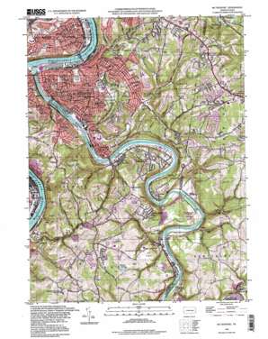
Mckeesport Topo Map Pennsylvania
To zoom in, hover over the map of Mckeesport
USGS Topo Quad 40079c7 - 1:24,000 scale
| Topo Map Name: | Mckeesport |
| USGS Topo Quad ID: | 40079c7 |
| Print Size: | ca. 21 1/4" wide x 27" high |
| Southeast Coordinates: | 40.25° N latitude / 79.75° W longitude |
| Map Center Coordinates: | 40.3125° N latitude / 79.8125° W longitude |
| U.S. State: | PA |
| Filename: | o40079c7.jpg |
| Download Map JPG Image: | Mckeesport topo map 1:24,000 scale |
| Map Type: | Topographic |
| Topo Series: | 7.5´ |
| Map Scale: | 1:24,000 |
| Source of Map Images: | United States Geological Survey (USGS) |
| Alternate Map Versions: |
Mc Keesport PA 1953, updated 1955 Download PDF Buy paper map Mc Keesport PA 1960, updated 1961 Download PDF Buy paper map Mc Keesport PA 1960, updated 1965 Download PDF Buy paper map Mc Keesport PA 1960, updated 1971 Download PDF Buy paper map Mc Keesport PA 1960, updated 1979 Download PDF Buy paper map Mc Keesport PA 1993, updated 1998 Download PDF Buy paper map McKeesport PA 2010 Download PDF Buy paper map McKeesport PA 2013 Download PDF Buy paper map McKeesport PA 2016 Download PDF Buy paper map |
1:24,000 Topo Quads surrounding Mckeesport
> Back to 40079a1 at 1:100,000 scale
> Back to 40078a1 at 1:250,000 scale
> Back to U.S. Topo Maps home
Mckeesport topo map: Gazetteer
Mckeesport: Airports
Inter County Airport elevation 330m 1082′Sugar-Bob Airport elevation 354m 1161′
Weiss Airport elevation 229m 751′
Mckeesport: Bridges
Boston Bridge elevation 219m 718′Fifteenth Street Bridge elevation 219m 718′
Fifth Avenue Bridge elevation 219m 718′
McKeesport Duquesne Bridge elevation 219m 718′
Mckeesport: Dams
Butlers Lake Dam elevation 220m 721′Mckeesport: Parks
North Buena Vista Historical Site elevation 238m 780′Renziehalusen Park elevation 283m 928′
White Oak Regional park elevation 333m 1092′
Mckeesport: Populated Places
Alpsville elevation 229m 751′Belle Bridge elevation 231m 757′
Boston elevation 232m 761′
Buena Vista elevation 235m 770′
Byerly elevation 367m 1204′
Central Highlands elevation 333m 1092′
Coulter elevation 237m 777′
Cowansburg elevation 248m 813′
Eden Park elevation 230m 754′
Emblem elevation 304m 997′
Fite Station elevation 339m 1112′
Greenock elevation 296m 971′
Guffey elevation 239m 784′
Industry elevation 238m 780′
Liberty elevation 278m 912′
Lincoln elevation 331m 1085′
Lovedale elevation 238m 780′
McKeesport elevation 233m 764′
Mount Vernon elevation 329m 1079′
Patterson Hill elevation 262m 859′
Port Vue elevation 328m 1076′
Riverton elevation 277m 908′
Robbins elevation 227m 744′
Scott Haven elevation 244m 800′
Shaner elevation 231m 757′
Stewartsville elevation 362m 1187′
Versailles elevation 254m 833′
Vista elevation 236m 774′
West Mifflin elevation 334m 1095′
White Oak elevation 249m 816′
Yohoghany elevation 281m 921′
Mckeesport: Post Offices
Boston Post Office elevation 231m 757′Buena Vista Post Office (historical) elevation 235m 770′
Central Highlands Post Office elevation 361m 1184′
Duquesne Post Office elevation 239m 784′
Frank Post Office (historical) elevation 279m 915′
Mckeesport: Reservoirs
Butlers Lake elevation 307m 1007′Mckeesport: Streams
Crawford Run elevation 219m 718′Crooked Run elevation 226m 741′
Jacks Run elevation 256m 839′
Little Sewickley Creek elevation 232m 761′
Long Run elevation 219m 718′
Youghiogheny River elevation 219m 718′
Mckeesport: Valleys
Boston Hollow elevation 230m 754′Guffey Hollow elevation 254m 833′
Harrison Hollow elevation 276m 905′
Possum Hollow elevation 243m 797′
Mckeesport digital topo map on disk
Buy this Mckeesport topo map showing relief, roads, GPS coordinates and other geographical features, as a high-resolution digital map file on DVD:


