New Florence Topo Map Pennsylvania
To zoom in, hover over the map of New Florence
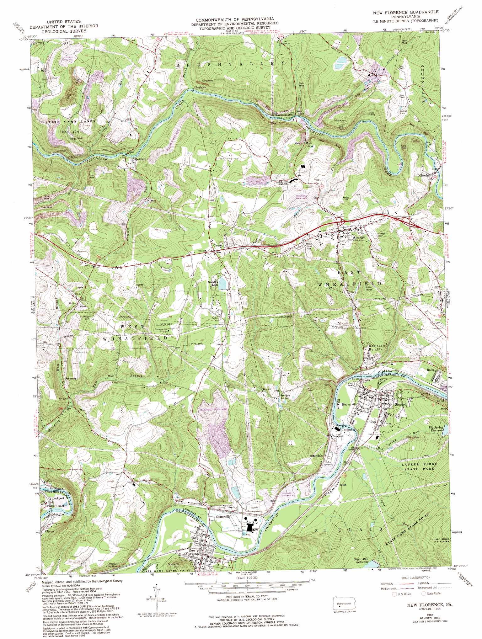
USGS Topo Quad 40079d1 - 1:24,000 scale
| Topo Map Name: | New Florence |
| USGS Topo Quad ID: | 40079d1 |
| Print Size: | ca. 21 1/4" wide x 27" high |
| Southeast Coordinates: | 40.375° N latitude / 79° W longitude |
| Map Center Coordinates: | 40.4375° N latitude / 79.0625° W longitude |
| U.S. State: | PA |
| Filename: | o40079d1.jpg |
| Download Map JPG Image: | New Florence topo map 1:24,000 scale |
| Map Type: | Topographic |
| Topo Series: | 7.5´ |
| Map Scale: | 1:24,000 |
| Source of Map Images: | United States Geological Survey (USGS) |
| Alternate Map Versions: |
New Florence PA 1964, updated 1966 Download PDF Buy paper map New Florence PA 1964, updated 1971 Download PDF Buy paper map New Florence PA 1964, updated 1973 Download PDF Buy paper map New Florence PA 1964, updated 1982 Download PDF Buy paper map New Florence PA 1964, updated 1993 Download PDF Buy paper map New Florence PA 1964, updated 1993 Download PDF Buy paper map New Florence PA 2010 Download PDF Buy paper map New Florence PA 2013 Download PDF Buy paper map New Florence PA 2016 Download PDF Buy paper map |
1:24,000 Topo Quads surrounding New Florence
Elderton |
Ernest |
Clymer |
Commodore |
Barnesboro |
Mcintyre |
Indiana |
Brush Valley |
Strongstown |
Colver |
Blairsville |
Bolivar |
New Florence |
Vintondale |
Nanty Glo |
Derry |
Wilpen |
Rachelwood |
Johnstown |
Geistown |
Stahlstown |
Ligonier |
Boswell |
Hooversville |
Windber |
> Back to 40079a1 at 1:100,000 scale
> Back to 40078a1 at 1:250,000 scale
> Back to U.S. Topo Maps home
New Florence topo map: Gazetteer
New Florence: Dams
Big Spring Dam elevation 416m 1364′District Dam elevation 394m 1292′
Sugar Run Dam elevation 488m 1601′
New Florence: Populated Places
Armagh elevation 466m 1528′Boltz elevation 366m 1200′
Centerville (historical) elevation 327m 1072′
Claghorn elevation 389m 1276′
Climax elevation 336m 1102′
Clyde elevation 556m 1824′
Conpitt Junction elevation 325m 1066′
Dias elevation 399m 1309′
Dilltown elevation 412m 1351′
Germany elevation 413m 1354′
Heshbon elevation 376m 1233′
Hooverville elevation 337m 1105′
India elevation 338m 1108′
Lockport elevation 320m 1049′
New Florence elevation 329m 1079′
Robb elevation 335m 1099′
Robindale (historical) elevation 328m 1076′
Robindale Heights elevation 354m 1161′
Seward elevation 347m 1138′
New Florence: Post Offices
Smokeless Post Office (historical) elevation 325m 1066′New Florence: Reservoirs
Big Spring Reservoir elevation 426m 1397′Hedges Lakes elevation 375m 1230′
High Ridge Reservoir elevation 394m 1292′
Holiday Lake elevation 514m 1686′
Sugar Run Reservoir elevation 495m 1624′
New Florence: Streams
Aulds Run elevation 353m 1158′Baldwin Creek elevation 329m 1079′
Big Spring Run elevation 328m 1076′
Brush Creek elevation 378m 1240′
East Branch Richards Run elevation 382m 1253′
Mardis Run elevation 392m 1286′
Mardis Run elevation 398m 1305′
Ramsey Run elevation 376m 1233′
Sugar Run elevation 335m 1099′
West Branch Richards Run elevation 382m 1253′
New Florence: Summits
Squirrel Hill elevation 433m 1420′New Florence digital topo map on disk
Buy this New Florence topo map showing relief, roads, GPS coordinates and other geographical features, as a high-resolution digital map file on DVD:
 map DVD")