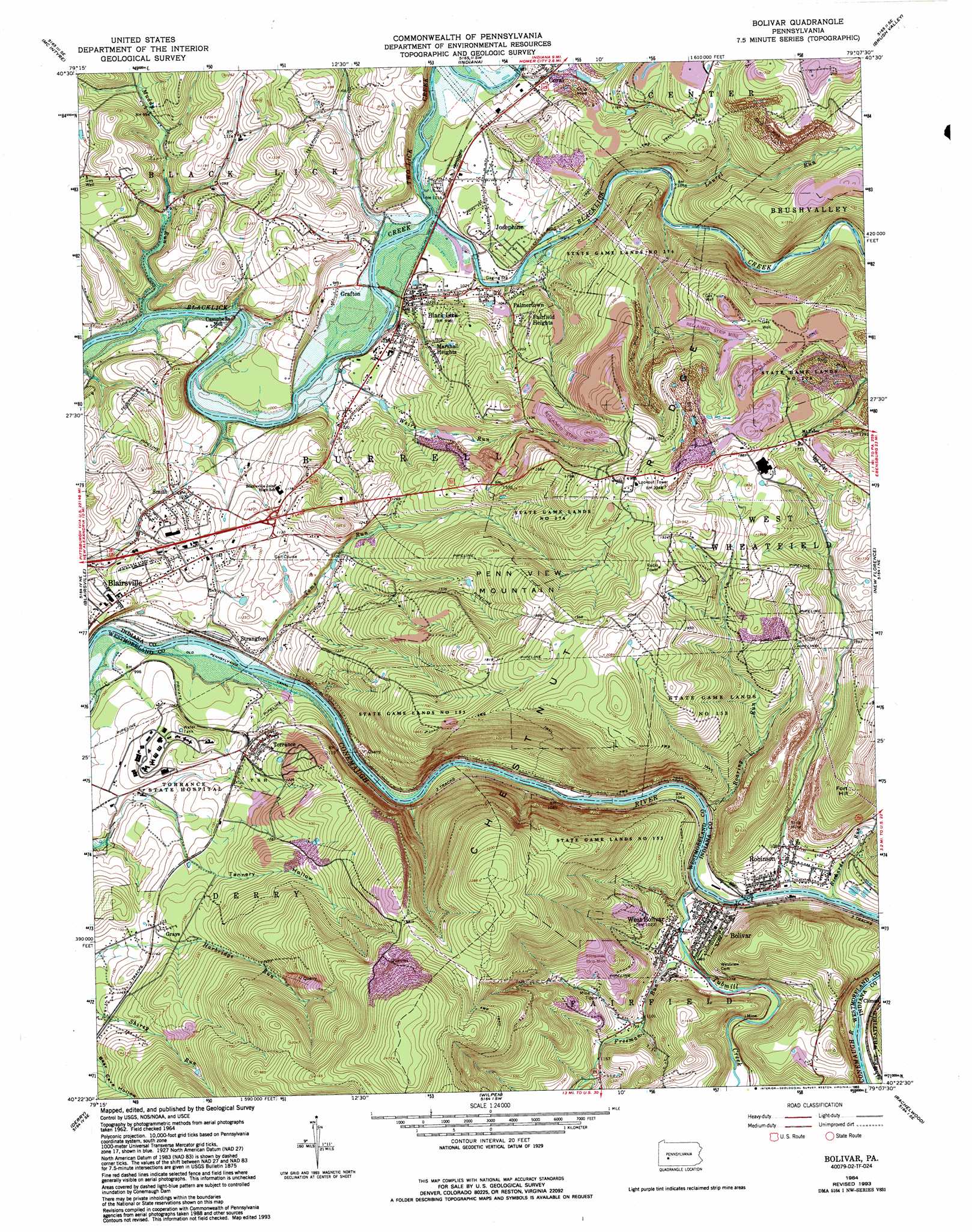
Bolivar Topo Map Pennsylvania
To zoom in, hover over the map of Bolivar
USGS Topo Quad 40079d2 - 1:24,000 scale
| Topo Map Name: | Bolivar |
| USGS Topo Quad ID: | 40079d2 |
| Print Size: | ca. 21 1/4" wide x 27" high |
| Southeast Coordinates: | 40.375° N latitude / 79.125° W longitude |
| Map Center Coordinates: | 40.4375° N latitude / 79.1875° W longitude |
| U.S. State: | PA |
| Filename: | o40079d2.jpg |
| Download Map JPG Image: | Bolivar topo map 1:24,000 scale |
| Map Type: | Topographic |
| Topo Series: | 7.5´ |
| Map Scale: | 1:24,000 |
| Source of Map Images: | United States Geological Survey (USGS) |
| Alternate Map Versions: |
Bolivar PA 1964, updated 1966 Download PDF Buy paper map Bolivar PA 1964, updated 1973 Download PDF Buy paper map Bolivar PA 1964, updated 1982 Download PDF Buy paper map Bolivar PA 1964, updated 1989 Download PDF Buy paper map Bolivar PA 1964, updated 1993 Download PDF Buy paper map Bolivar PA 1964, updated 1993 Download PDF Buy paper map Bolivar PA 2010 Download PDF Buy paper map Bolivar PA 2013 Download PDF Buy paper map Bolivar PA 2016 Download PDF Buy paper map |
1:24,000 Topo Quads surrounding Bolivar
Whitesburg |
Elderton |
Ernest |
Clymer |
Commodore |
Avonmore |
Mcintyre |
Indiana |
Brush Valley |
Strongstown |
Saltsburg |
Blairsville |
Bolivar |
New Florence |
Vintondale |
Latrobe |
Derry |
Wilpen |
Rachelwood |
Johnstown |
Mammoth |
Stahlstown |
Ligonier |
Boswell |
Hooversville |
> Back to 40079a1 at 1:100,000 scale
> Back to 40078a1 at 1:250,000 scale
> Back to U.S. Topo Maps home
Bolivar topo map: Gazetteer
Bolivar: Canals
Old Pennsylvania Canal elevation 291m 954′Bolivar: Crossings
Blairsville Intersection elevation 346m 1135′Bolivar: Dams
Edwards Dam elevation 383m 1256′Graceton Dam elevation 368m 1207′
Bolivar: Gaps
Conemaugh Water Gap elevation 299m 980′Bolivar: Parks
Pine Ridge County Park elevation 376m 1233′State Game Lands Number 153 elevation 511m 1676′
State Game Lands Number 276 elevation 401m 1315′
Bolivar: Populated Places
Black Lick elevation 285m 935′Bolivar elevation 315m 1033′
Campbells Mill elevation 296m 971′
Coral elevation 308m 1010′
Fairfield Heights elevation 360m 1181′
Grafton elevation 302m 990′
Grays elevation 354m 1161′
Josephine elevation 314m 1030′
Marshall Heights elevation 359m 1177′
Palmertown elevation 323m 1059′
Robinson elevation 337m 1105′
Smith elevation 337m 1105′
Strangford elevation 303m 994′
Torrance elevation 360m 1181′
West Bolivar elevation 313m 1026′
Bolivar: Post Offices
Torrance Post Office (historical) elevation 365m 1197′Bolivar: Reservoirs
Edwards Pond elevation 383m 1256′Gracetown Reservoir elevation 368m 1207′
Bolivar: Streams
Freeman Run elevation 312m 1023′Laurel Run elevation 333m 1092′
Muddy Run elevation 290m 951′
Richards Run elevation 312m 1023′
Roaring Run elevation 312m 1023′
Toms Run elevation 286m 938′
Tubmill Creek elevation 300m 984′
Two Lick Creek elevation 289m 948′
Weirs Run elevation 290m 951′
Bolivar: Summits
Bear Rocks elevation 745m 2444′Fort Hill elevation 525m 1722′
Penn View Mountain elevation 577m 1893′
Bolivar: Valleys
Tannery Hollow elevation 344m 1128′Bolivar digital topo map on disk
Buy this Bolivar topo map showing relief, roads, GPS coordinates and other geographical features, as a high-resolution digital map file on DVD:
 map DVD")