Pittsburgh East Topo Map Pennsylvania
To zoom in, hover over the map of Pittsburgh East
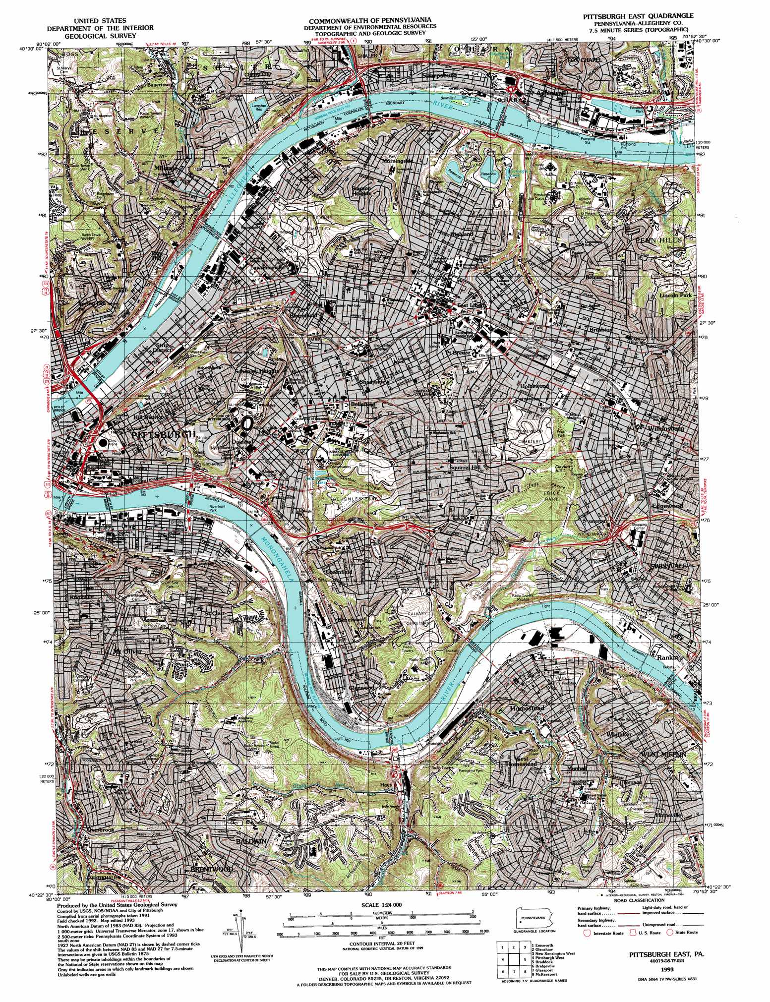
USGS Topo Quad 40079d8 - 1:24,000 scale
| Topo Map Name: | Pittsburgh East |
| USGS Topo Quad ID: | 40079d8 |
| Print Size: | ca. 21 1/4" wide x 27" high |
| Southeast Coordinates: | 40.375° N latitude / 79.875° W longitude |
| Map Center Coordinates: | 40.4375° N latitude / 79.9375° W longitude |
| U.S. State: | PA |
| Filename: | o40079d8.jpg |
| Download Map JPG Image: | Pittsburgh East topo map 1:24,000 scale |
| Map Type: | Topographic |
| Topo Series: | 7.5´ |
| Map Scale: | 1:24,000 |
| Source of Map Images: | United States Geological Survey (USGS) |
| Alternate Map Versions: |
Pittsburgh East PA 1951 Download PDF Buy paper map Pittsburgh East PA 1951 Download PDF Buy paper map Pittsburg East PA 1951 Download PDF Buy paper map Pittsburgh East PA 1956, updated 1959 Download PDF Buy paper map Pittsburgh East PA 1960, updated 1961 Download PDF Buy paper map Pittsburgh East PA 1960, updated 1966 Download PDF Buy paper map Pittsburgh East PA 1960, updated 1971 Download PDF Buy paper map Pittsburgh East PA 1960, updated 1973 Download PDF Buy paper map Pittsburgh East PA 1993, updated 1994 Download PDF Buy paper map Pittsburgh East PA 1993, updated 1994 Download PDF Buy paper map Pittsburgh East PA 1997, updated 2000 Download PDF Buy paper map Pittsburgh East PA 1997, updated 2000 Download PDF Buy paper map Pittsburgh East PA 2010 Download PDF Buy paper map Pittsburgh East PA 2013 Download PDF Buy paper map Pittsburgh East PA 2016 Download PDF Buy paper map |
1:24,000 Topo Quads surrounding Pittsburgh East
Baden |
Mars |
Valencia |
Curtisville |
Freeport |
Ambridge |
Emsworth |
Glenshaw |
New Kensington West |
New Kensington East |
Oakdale |
Pittsburgh West |
Pittsburgh East |
Braddock |
Murrysville |
Canonsburg |
Bridgeville |
Glassport |
Mckeesport |
Irwin |
Washington East |
Hackett |
Monongahela |
Donora |
Smithton |
> Back to 40079a1 at 1:100,000 scale
> Back to 40078a1 at 1:250,000 scale
> Back to U.S. Topo Maps home
Pittsburgh East topo map: Gazetteer
Pittsburgh East: Airports
Allegheny General Hospital Heliport elevation 250m 820′Aspinwall Airport elevation 220m 721′
Aspinwall Seaplane Base (historical) elevation 220m 721′
Magee-Womens Hospital Airport elevation 282m 925′
Police Airport elevation 222m 728′
Rockwell International Heliport elevation 292m 958′
US Steel Rooftop Heliport elevation 230m 754′
West Penn Hospital Heliport elevation 293m 961′
Pittsburgh East: Bridges
Bloomfield Bridge elevation 282m 925′Brady Bridge elevation 216m 708′
Glenwood Bridge elevation 216m 708′
Herron Bridge elevation 233m 764′
Highland Park Bridge elevation 220m 721′
Homestead Bridge elevation 216m 708′
Liberty Bridge elevation 216m 708′
Nineteenth Street Bridge elevation 216m 708′
Rankin Bridge elevation 216m 708′
Sixteenth Street Bridge elevation 216m 708′
Sixty-Second Street Bridge elevation 216m 708′
Tenth Street Bridge elevation 216m 708′
Thrity-First Street Bridge elevation 221m 725′
Washington Crossing Bridge elevation 216m 708′
Pittsburgh East: Crossings
Interchange 1C elevation 219m 718′Interchange 1D elevation 222m 728′
Interchange 2B elevation 228m 748′
Interchange 3A elevation 231m 757′
Interchange 3B elevation 230m 754′
Interchange 5 elevation 284m 931′
Interchange 7 elevation 259m 849′
Interchange 7C elevation 225m 738′
Interchange 8A elevation 230m 754′
Interchange 8B elevation 231m 757′
Interchange 9 elevation 238m 780′
Pittsburgh East: Dams
Allegheny River Lock and Dam Two elevation 252m 826′Lock Number Two elevation 219m 718′
Pittsburgh East: Islands
Herrs Island elevation 221m 725′Sixmile Island elevation 216m 708′
Pittsburgh East: Lakes
Carnegie Lake elevation 283m 928′Panther Hollow Lake elevation 247m 810′
Pittsburgh East: Parks
Ammon Playground elevation 321m 1053′Arlington Playground elevation 365m 1197′
Armstrong Playground elevation 230m 754′
Assumption Commons elevation 266m 872′
Brentwood Park elevation 350m 1148′
Cowley Athletic Field elevation 272m 892′
Elm Leaf Park elevation 331m 1085′
Flag Plaza elevation 260m 853′
Forbes Field (historical) elevation 271m 889′
Frazier Field elevation 277m 908′
Frick Park elevation 332m 1089′
Gesling Stadium and Athletic Field elevation 289m 948′
Grandview Park elevation 363m 1190′
Gumberg Green Space elevation 260m 853′
Herron Hill Park elevation 388m 1272′
Highland Park elevation 300m 984′
Kennard Playground elevation 312m 1023′
Leslie Recreation Center elevation 236m 774′
Magee Playground elevation 297m 974′
McCloskey Field elevation 358m 1174′
McCloskey Field elevation 258m 846′
McKelvey Playground elevation 325m 1066′
Mellon Park elevation 292m 958′
Mellon Square Park elevation 229m 751′
Paulson Playground elevation 307m 1007′
Phillips Park elevation 358m 1174′
Phipps Conservatory elevation 282m 925′
Pitt Stadium elevation 320m 1049′
River Front Park elevation 222m 728′
Rooney Field elevation 272m 892′
Rooney Field elevation 272m 892′
Schenley Park elevation 318m 1043′
Schenley Plaza elevation 274m 898′
Sennott Square elevation 280m 918′
Troy Hill Playground elevation 278m 912′
West Penn Recreation Center elevation 277m 908′
Westinghouse Park elevation 286m 938′
Winter Playground elevation 327m 1072′
Pittsburgh East: Populated Places
Allentown elevation 272m 892′Arlington elevation 235m 770′
Aspinwall elevation 229m 751′
Bauerstown elevation 246m 807′
Bellefield elevation 283m 928′
Belmar elevation 300m 984′
Bloomfield elevation 287m 941′
Brushton elevation 282m 925′
Carrick elevation 331m 1085′
Cherry City elevation 258m 846′
East Allegheny elevation 268m 879′
East Liberty elevation 280m 918′
Edgewood elevation 298m 977′
Frick Park elevation 287m 941′
Friendship elevation 296m 971′
Garfield elevation 340m 1115′
Glen Hazel elevation 324m 1062′
Glenwood elevation 235m 770′
Greenfield elevation 324m 1062′
Hays elevation 232m 761′
Hazelwood elevation 286m 938′
Highland elevation 295m 967′
Hill Distrct elevation 303m 994′
Homestead elevation 240m 787′
Homestead Park elevation 269m 882′
Homeville elevation 329m 1079′
Homewood elevation 298m 977′
Knoxville elevation 340m 1115′
Larimer elevation 279m 915′
Lawrenceville elevation 245m 803′
Lincoln Park elevation 314m 1030′
Lincoln-Lemington elevation 312m 1023′
Millvale elevation 242m 793′
Morningside elevation 278m 912′
Mount Olive elevation 338m 1108′
Mount Oliver elevation 350m 1148′
Munhall elevation 318m 1043′
New Homestead elevation 365m 1197′
Oakland elevation 315m 1033′
Overbrook elevation 301m 987′
Pittsburgh elevation 233m 764′
Point Breeze elevation 287m 941′
Polish Hill elevation 265m 869′
Rankin elevation 268m 879′
Regent Square elevation 235m 770′
Saint Clair elevation 353m 1158′
Schenley Heights elevation 352m 1154′
Shadyside elevation 272m 892′
Sharpsburg elevation 225m 738′
Soho elevation 251m 823′
South Side Flats elevation 228m 748′
Southside Slopes elevation 242m 793′
Spring Garden elevation 272m 892′
Spring Hill elevation 324m 1062′
Squirrel Hill elevation 343m 1125′
Stanton Heights elevation 347m 1138′
Strip District elevation 220m 721′
Swisshelm Park elevation 278m 912′
Swissvale elevation 312m 1023′
Terrace elevation 323m 1059′
Troy Hill elevation 268m 879′
Uptown elevation 225m 738′
West Homestead elevation 317m 1040′
Whitaker elevation 303m 994′
Wilkinsburg elevation 287m 941′
Pittsburgh East: Post Offices
Arsenal Post Office elevation 231m 757′Blawnox Post Office elevation 228m 748′
Bloomfield Post Office elevation 280m 918′
Carson Post Office elevation 228m 748′
East Liberty Post Office elevation 279m 915′
Etna Post Office elevation 233m 764′
Grant Street Post Office elevation 229m 751′
Hazelwood Post Office elevation 239m 784′
Homestead Post Office elevation 237m 777′
Homewood Post Office elevation 286m 938′
Millvale Post Office elevation 225m 738′
Mount Oliver Post Office elevation 352m 1154′
Munhall Post Office elevation 338m 1108′
Oakland Post Office elevation 265m 869′
Sharpsburg Post Office elevation 225m 738′
Squirrel Hill Post Office elevation 336m 1102′
Swissvale Post Office elevation 281m 921′
Uptown Pittsburgh Post Office elevation 246m 807′
Wilkinsburg Finance Post Office elevation 284m 931′
Wylie Post Office elevation 292m 958′
Pittsburgh East: Reservoirs
Allegheny River Pool Two elevation 252m 826′Lampher Reservoir elevation 293m 961′
Pittsburgh East: Streams
Girtys Run elevation 225m 738′Glass Run elevation 228m 748′
Guyasuta Run elevation 220m 721′
Homestead Run elevation 218m 715′
Ninemile Run elevation 219m 718′
Pine Creek elevation 217m 711′
Shades Run elevation 232m 761′
Squaw Run elevation 220m 721′
Streets Run elevation 219m 718′
West Run elevation 216m 708′
Pittsburgh East: Tunnels
Armstrong Tunnel elevation 272m 892′Squirrel Hill Tunnel elevation 336m 1102′
Pittsburgh East: Valleys
Panther Hollow elevation 244m 800′Pittsburgh East digital topo map on disk
Buy this Pittsburgh East topo map showing relief, roads, GPS coordinates and other geographical features, as a high-resolution digital map file on DVD:
 map DVD")