Indiana Topo Map Pennsylvania
To zoom in, hover over the map of Indiana
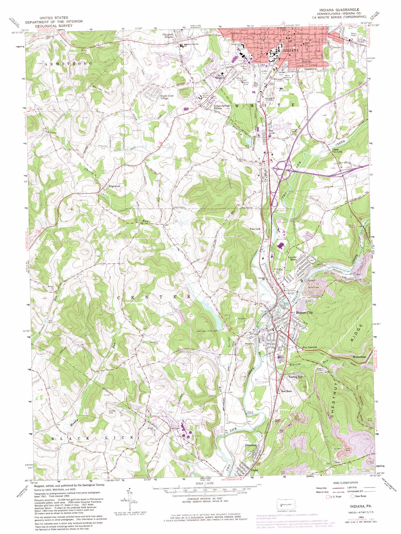
USGS Topo Quad 40079e2 - 1:24,000 scale
| Topo Map Name: | Indiana |
| USGS Topo Quad ID: | 40079e2 |
| Print Size: | ca. 21 1/4" wide x 27" high |
| Southeast Coordinates: | 40.5° N latitude / 79.125° W longitude |
| Map Center Coordinates: | 40.5625° N latitude / 79.1875° W longitude |
| U.S. State: | PA |
| Filename: | o40079e2.jpg |
| Download Map JPG Image: | Indiana topo map 1:24,000 scale |
| Map Type: | Topographic |
| Topo Series: | 7.5´ |
| Map Scale: | 1:24,000 |
| Source of Map Images: | United States Geological Survey (USGS) |
| Alternate Map Versions: |
Indiana PA 1963, updated 1965 Download PDF Buy paper map Indiana PA 1963, updated 1969 Download PDF Buy paper map Indiana PA 1963, updated 1973 Download PDF Buy paper map Indiana PA 1963, updated 1982 Download PDF Buy paper map Indiana PA 2010 Download PDF Buy paper map Indiana PA 2013 Download PDF Buy paper map Indiana PA 2016 Download PDF Buy paper map |
1:24,000 Topo Quads surrounding Indiana
Mosgrove |
Rural Valley |
Plumville |
Marion Center |
Rochester Mills |
Whitesburg |
Elderton |
Ernest |
Clymer |
Commodore |
Avonmore |
Mcintyre |
Indiana |
Brush Valley |
Strongstown |
Saltsburg |
Blairsville |
Bolivar |
New Florence |
Vintondale |
Latrobe |
Derry |
Wilpen |
Rachelwood |
Johnstown |
> Back to 40079e1 at 1:100,000 scale
> Back to 40078a1 at 1:250,000 scale
> Back to U.S. Topo Maps home
Indiana topo map: Gazetteer
Indiana: Dams
Cherry Run Dam elevation 319m 1046′Indiana: Parks
Mack Memorial Park elevation 379m 1243′Indiana: Populated Places
Ben Avon elevation 361m 1184′Claypoole Heights elevation 393m 1289′
Coy elevation 360m 1181′
Coy Junction elevation 358m 1174′
Crete elevation 422m 1384′
Edgewood elevation 366m 1200′
Getty Heights elevation 398m 1305′
Graceton elevation 329m 1079′
Grandview elevation 404m 1325′
Homer City elevation 314m 1030′
Indian Springs Estates elevation 392m 1286′
Indiana elevation 396m 1299′
Lucerne Mines elevation 350m 1148′
Red Barn elevation 337m 1105′
Shado-Wood Village elevation 408m 1338′
Smathers elevation 377m 1236′
Tearing Run elevation 348m 1141′
Tide elevation 341m 1118′
Two Lick elevation 332m 1089′
Upper Two Lick elevation 329m 1079′
Waterman elevation 422m 1384′
Indiana: Reservoirs
Cherry Run Lake elevation 319m 1046′Coke Company Pond elevation 335m 1099′
Indiana: Streams
Cherry Run elevation 302m 990′Marsh Run elevation 373m 1223′
McCarthy Run elevation 351m 1151′
Stoney Run elevation 318m 1043′
Tearing Run elevation 311m 1020′
Whites Run elevation 375m 1230′
Yellow Creek elevation 318m 1043′
Indiana: Summits
Warner Hill elevation 490m 1607′Indiana digital topo map on disk
Buy this Indiana topo map showing relief, roads, GPS coordinates and other geographical features, as a high-resolution digital map file on DVD:
 map DVD")