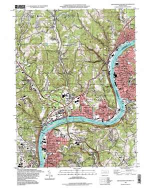
New Kensington West Topo Map Pennsylvania
To zoom in, hover over the map of New Kensington West
USGS Topo Quad 40079e7 - 1:24,000 scale
| Topo Map Name: | New Kensington West |
| USGS Topo Quad ID: | 40079e7 |
| Print Size: | ca. 21 1/4" wide x 27" high |
| Southeast Coordinates: | 40.5° N latitude / 79.75° W longitude |
| Map Center Coordinates: | 40.5625° N latitude / 79.8125° W longitude |
| U.S. State: | PA |
| Filename: | o40079e7.jpg |
| Download Map JPG Image: | New Kensington West topo map 1:24,000 scale |
| Map Type: | Topographic |
| Topo Series: | 7.5´ |
| Map Scale: | 1:24,000 |
| Source of Map Images: | United States Geological Survey (USGS) |
| Alternate Map Versions: |
New Kensington West PA 1953, updated 1955 Download PDF Buy paper map New Kensington West PA 1960, updated 1961 Download PDF Buy paper map New Kensington West PA 1960, updated 1967 Download PDF Buy paper map New Kensington West PA 1960, updated 1971 Download PDF Buy paper map New Kensington West PA 1960, updated 1979 Download PDF Buy paper map New Kensington West PA 1993, updated 1993 Download PDF Buy paper map New Kensington West PA 1993, updated 1998 Download PDF Buy paper map New Kensington West PA 2010 Download PDF Buy paper map New Kensington West PA 2013 Download PDF Buy paper map New Kensington West PA 2016 Download PDF Buy paper map |
1:24,000 Topo Quads surrounding New Kensington West
> Back to 40079e1 at 1:100,000 scale
> Back to 40078a1 at 1:250,000 scale
> Back to U.S. Topo Maps home
New Kensington West topo map: Gazetteer
New Kensington West: Airports
Seitz Field elevation 275m 902′Strauss-Hamilton Airport elevation 293m 961′
West Penn Airport elevation 337m 1105′
New Kensington West: Bars
Merriman Bars elevation 259m 849′New Kensington West: Bridges
C L Schmitt Bridge elevation 224m 734′Hulton Bridge elevation 220m 721′
New Kensington West: Crossings
Interchange 48 elevation 244m 800′Pennsylvania Turnpike Interchange 5 elevation 232m 761′
New Kensington West: Dams
Allegheny River Lock and Dam Three elevation 225m 738′C. W. Bill Young Lock and Dam elevation 220m 721′
Harmon Refuse Bank Dam elevation 333m 1092′
Russellton Slurry Pond Three Dam elevation 340m 1115′
New Kensington West: Islands
Fourteen Mile Island elevation 225m 738′Twelvemile Island elevation 224m 734′
New Kensington West: Parks
Allegheny Islands State Park elevation 224m 734′Dark Hollow Woods Park elevation 272m 892′
Deer Lakes County Regional Park elevation 313m 1026′
Emmerling Park elevation 252m 826′
Penn Hills Community Park elevation 241m 790′
Riverview Park elevation 225m 738′
New Kensington West: Populated Places
Acmetonia elevation 228m 748′Allegheny Acres elevation 330m 1082′
Arnold elevation 241m 790′
Barking elevation 235m 770′
Broadview elevation 367m 1204′
Cheswick elevation 235m 770′
Creighton elevation 263m 862′
East Oakmont elevation 300m 984′
Fairview Heights elevation 345m 1131′
Glassmere elevation 279m 915′
Harmar Heights elevation 292m 958′
Harmarville elevation 231m 757′
Harwick elevation 291m 954′
Hites elevation 238m 780′
Indianola elevation 281m 921′
Leechburg elevation 287m 941′
Logans Ferry Heights elevation 271m 889′
Lower Burrell elevation 229m 751′
Magill Heights elevation 362m 1187′
Milltown elevation 272m 892′
Montrose Hill elevation 296m 971′
Mount Vernon elevation 293m 961′
New Kensington elevation 239m 784′
Newfield elevation 318m 1043′
Oakmont elevation 236m 774′
Orville elevation 294m 964′
Parnassus elevation 228m 748′
Penn Hills elevation 287m 941′
Point Breeze elevation 284m 931′
River Valley elevation 266m 872′
Rural Ridge elevation 259m 849′
Russellton elevation 291m 954′
Springdale elevation 246m 807′
Tarentum elevation 242m 793′
Valemont Heights elevation 335m 1099′
Valley Camp elevation 241m 790′
Verona elevation 232m 761′
Verona Hills elevation 336m 1102′
Walter Chapel elevation 270m 885′
West New Kensington elevation 232m 761′
West Tarentum elevation 278m 912′
New Kensington West: Post Offices
Arnold Post Office elevation 237m 777′Cheswick Post Office elevation 232m 761′
Creighton Post Office elevation 235m 770′
Harwick Post Office elevation 293m 961′
New Kensington Post Office elevation 236m 774′
Oakmont Post Office elevation 235m 770′
Parnassus Post Office elevation 227m 744′
Russellton Post Office elevation 284m 931′
Springdale Post Office elevation 243m 797′
Verona Post Office elevation 230m 754′
New Kensington West: Reservoirs
Allegheny River Pool Three elevation 225m 738′Point Breeze Reservoir elevation 343m 1125′
Pond Three elevation 340m 1115′
Springdale Lake elevation 285m 935′
West Deer Lake elevation 343m 1125′
New Kensington West: Streams
Bailey Run elevation 228m 748′Blacks Run elevation 224m 734′
Blue Run elevation 275m 902′
Bodies Run elevation 263m 862′
Bull Creek elevation 227m 744′
Campbell Run elevation 238m 780′
Clarks Run elevation 304m 997′
Crawford Run elevation 228m 748′
Cunningham Run elevation 256m 839′
Days Run elevation 284m 931′
Deer Creek elevation 225m 738′
Falling Springs Run elevation 235m 770′
Guys Run elevation 220m 721′
Indian Creek elevation 221m 725′
Little Bull Creek elevation 241m 790′
Little Deer Creek elevation 231m 757′
Little Pucketa Creek elevation 225m 738′
Long Run elevation 243m 797′
Plum Creek elevation 220m 721′
Powers Run elevation 226m 741′
Pucketa Creek elevation 225m 738′
Rawlins Run elevation 241m 790′
Riddle Run elevation 224m 734′
Tawney Run elevation 226m 741′
Yutes Run elevation 281m 921′
New Kensington West: Summits
Rich Hill elevation 365m 1197′New Kensington West: Valleys
Desperation Hollow elevation 244m 800′New Kensington West digital topo map on disk
Buy this New Kensington West topo map showing relief, roads, GPS coordinates and other geographical features, as a high-resolution digital map file on DVD:


