Leechburg Topo Map Pennsylvania
To zoom in, hover over the map of Leechburg
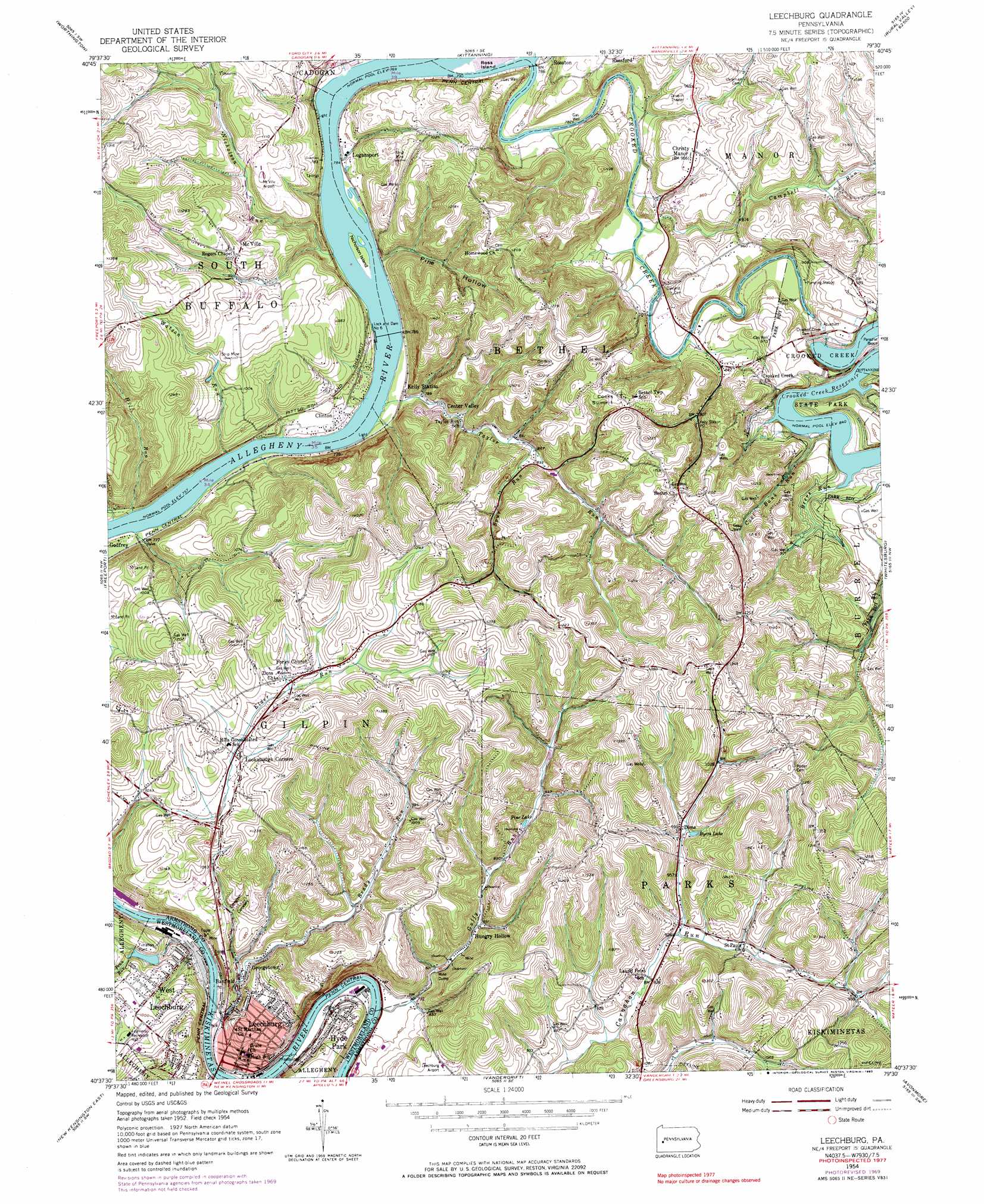
USGS Topo Quad 40079f5 - 1:24,000 scale
| Topo Map Name: | Leechburg |
| USGS Topo Quad ID: | 40079f5 |
| Print Size: | ca. 21 1/4" wide x 27" high |
| Southeast Coordinates: | 40.625° N latitude / 79.5° W longitude |
| Map Center Coordinates: | 40.6875° N latitude / 79.5625° W longitude |
| U.S. State: | PA |
| Filename: | o40079f5.jpg |
| Download Map JPG Image: | Leechburg topo map 1:24,000 scale |
| Map Type: | Topographic |
| Topo Series: | 7.5´ |
| Map Scale: | 1:24,000 |
| Source of Map Images: | United States Geological Survey (USGS) |
| Alternate Map Versions: |
Leechburg PA 1954, updated 1956 Download PDF Buy paper map Leechburg PA 1954, updated 1966 Download PDF Buy paper map Leechburg PA 1954, updated 1970 Download PDF Buy paper map Leechburg PA 1954, updated 1983 Download PDF Buy paper map Leechburg PA 1954, updated 1983 Download PDF Buy paper map Leechburg PA 2010 Download PDF Buy paper map Leechburg PA 2013 Download PDF Buy paper map Leechburg PA 2016 Download PDF Buy paper map |
1:24,000 Topo Quads surrounding Leechburg
East Butler |
Chicora |
East Brady |
Templeton |
Distant |
Saxonburg |
Worthington |
Kittanning |
Mosgrove |
Rural Valley |
Curtisville |
Freeport |
Leechburg |
Whitesburg |
Elderton |
New Kensington West |
New Kensington East |
Vandergrift |
Avonmore |
Mcintyre |
Braddock |
Murrysville |
Slickville |
Saltsburg |
Blairsville |
> Back to 40079e1 at 1:100,000 scale
> Back to 40078a1 at 1:250,000 scale
> Back to U.S. Topo Maps home
Leechburg topo map: Gazetteer
Leechburg: Airports
Kikkatuck Airport elevation 237m 777′Leechburg Airport elevation 295m 967′
McVille Airport elevation 301m 987′
Leechburg: Dams
Allegheny River Lock and Dam Six elevation 234m 767′Crooked Creek Dam elevation 279m 915′
Leechburg-Crooked Creek Dam elevation 276m 905′
Leechburg: Islands
Nicholson Island elevation 234m 767′Ross Island elevation 234m 767′
Leechburg: Lakes
Byers Lake elevation 310m 1017′Pine Lake elevation 279m 915′
Leechburg: Parks
Crooked Creek State Park elevation 295m 967′Leechburg: Populated Places
Banfield elevation 249m 816′Center Valley elevation 246m 807′
Christy Manor elevation 294m 964′
Clinton elevation 239m 784′
Cooks Summit elevation 343m 1125′
Dime elevation 304m 997′
Forks Church elevation 345m 1131′
Georgetown elevation 255m 836′
Hungry Hollow elevation 253m 830′
Hyde Park elevation 245m 803′
Leechburg elevation 242m 793′
Lookabough Corners elevation 334m 1095′
McVille elevation 326m 1069′
Neale elevation 267m 875′
Old Gum Tree elevation 362m 1187′
Tunnelville (historical) elevation 256m 839′
Leechburg: Post Offices
Dime Post Office (historical) elevation 304m 997′Logansport Post Office (historical) elevation 263m 862′
Neale Post Office (historical) elevation 246m 807′
Leechburg: Reservoirs
Allegheny River Pool Six elevation 234m 767′Beltzville Dam Reservoir elevation 276m 905′
Crooked Creek Lake elevation 289m 948′
Leechburg: Streams
Beers Run elevation 256m 839′Brady Run elevation 227m 744′
Campbell Run elevation 241m 790′
Coal Bank Run elevation 256m 839′
Crooked Creek elevation 237m 777′
Guffy Run elevation 238m 780′
Hill Run elevation 231m 757′
Nicholson Run elevation 234m 767′
Penn Run elevation 264m 866′
Spur Run elevation 261m 856′
Taylor Run elevation 232m 761′
Watson Run elevation 260m 853′
Leechburg: Valleys
Pine Hollow elevation 243m 797′Leechburg digital topo map on disk
Buy this Leechburg topo map showing relief, roads, GPS coordinates and other geographical features, as a high-resolution digital map file on DVD:
 map DVD")