Freeport Topo Map Pennsylvania
To zoom in, hover over the map of Freeport
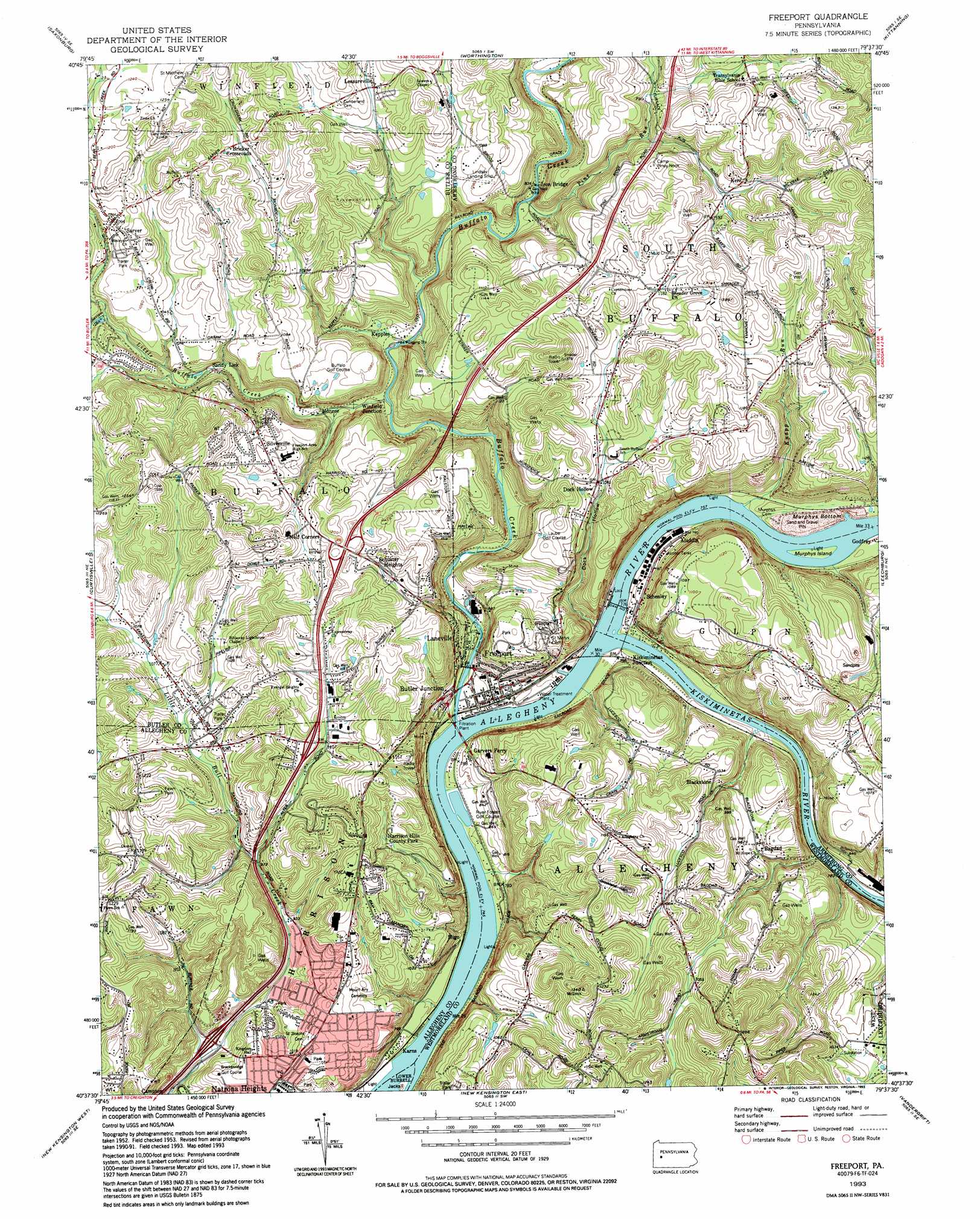
USGS Topo Quad 40079f6 - 1:24,000 scale
| Topo Map Name: | Freeport |
| USGS Topo Quad ID: | 40079f6 |
| Print Size: | ca. 21 1/4" wide x 27" high |
| Southeast Coordinates: | 40.625° N latitude / 79.625° W longitude |
| Map Center Coordinates: | 40.6875° N latitude / 79.6875° W longitude |
| U.S. State: | PA |
| Filename: | o40079f6.jpg |
| Download Map JPG Image: | Freeport topo map 1:24,000 scale |
| Map Type: | Topographic |
| Topo Series: | 7.5´ |
| Map Scale: | 1:24,000 |
| Source of Map Images: | United States Geological Survey (USGS) |
| Alternate Map Versions: |
Freeport PA 1953, updated 1955 Download PDF Buy paper map Freeport PA 1953, updated 1965 Download PDF Buy paper map Freeport PA 1953, updated 1970 Download PDF Buy paper map Freeport PA 1953, updated 1979 Download PDF Buy paper map Freeport PA 1993, updated 1993 Download PDF Buy paper map Freeport PA 1998, updated 2000 Download PDF Buy paper map Freeport PA 2010 Download PDF Buy paper map Freeport PA 2013 Download PDF Buy paper map Freeport PA 2016 Download PDF Buy paper map |
1:24,000 Topo Quads surrounding Freeport
Mount Chestnut |
East Butler |
Chicora |
East Brady |
Templeton |
Butler |
Saxonburg |
Worthington |
Kittanning |
Mosgrove |
Valencia |
Curtisville |
Freeport |
Leechburg |
Whitesburg |
Glenshaw |
New Kensington West |
New Kensington East |
Vandergrift |
Avonmore |
Pittsburgh East |
Braddock |
Murrysville |
Slickville |
Saltsburg |
> Back to 40079e1 at 1:100,000 scale
> Back to 40078a1 at 1:250,000 scale
> Back to U.S. Topo Maps home
Freeport topo map: Gazetteer
Freeport: Airports
Heineman Airport elevation 228m 748′Lindsay Airport elevation 326m 1069′
Snider Airport elevation 227m 744′
Freeport: Dams
Allegheny River Lock and Dam Five elevation 227m 744′Dam Number Five elevation 231m 757′
Freeport: Flats
Murphys Bottom elevation 237m 777′Freeport: Islands
Murphy Island elevation 231m 757′Freeport: Parks
Harrison Hills County Park elevation 352m 1154′Freeport: Populated Places
Aladdin elevation 242m 793′Bagdad elevation 283m 928′
Birdville elevation 271m 889′
Blackstone elevation 302m 990′
Bricker Crossroads elevation 351m 1151′
Butler Junction elevation 251m 823′
Dock Hollow elevation 329m 1079′
Freeport elevation 241m 790′
Garvers Ferry elevation 258m 846′
Godfrey elevation 235m 770′
Harbison elevation 302m 990′
Karns elevation 249m 816′
Kepples elevation 246m 807′
Kerr elevation 349m 1145′
Kiskiminetas Junction elevation 241m 790′
Laneville elevation 237m 777′
Leasureville elevation 336m 1102′
Monroe elevation 244m 800′
Sandy Lick elevation 281m 921′
Sarver elevation 335m 1099′
Schenley elevation 264m 866′
Schuster Heights elevation 361m 1184′
Silverville elevation 337m 1105′
Sligo elevation 236m 774′
Van Dykes elevation 355m 1164′
Winfield Junction elevation 246m 807′
Freeport: Post Offices
Freeport Post Office elevation 239m 784′Ingleside Post Office (historical) elevation 258m 846′
Lucesco Post Office (historical) elevation 241m 790′
Freeport: Reservoirs
Allegheny River Pool Five elevation 227m 744′Freeport: Streams
Big Run elevation 232m 761′Buffalo Creek elevation 231m 757′
Elder Run elevation 230m 754′
Kiskiminetas River elevation 227m 744′
Knapp Run elevation 231m 757′
Little Buffalo Creek elevation 242m 793′
Pine Run elevation 249m 816′
Sarver Run elevation 291m 954′
Freeport: Valleys
Dock Hollow elevation 233m 764′Freeport digital topo map on disk
Buy this Freeport topo map showing relief, roads, GPS coordinates and other geographical features, as a high-resolution digital map file on DVD:
 map DVD")