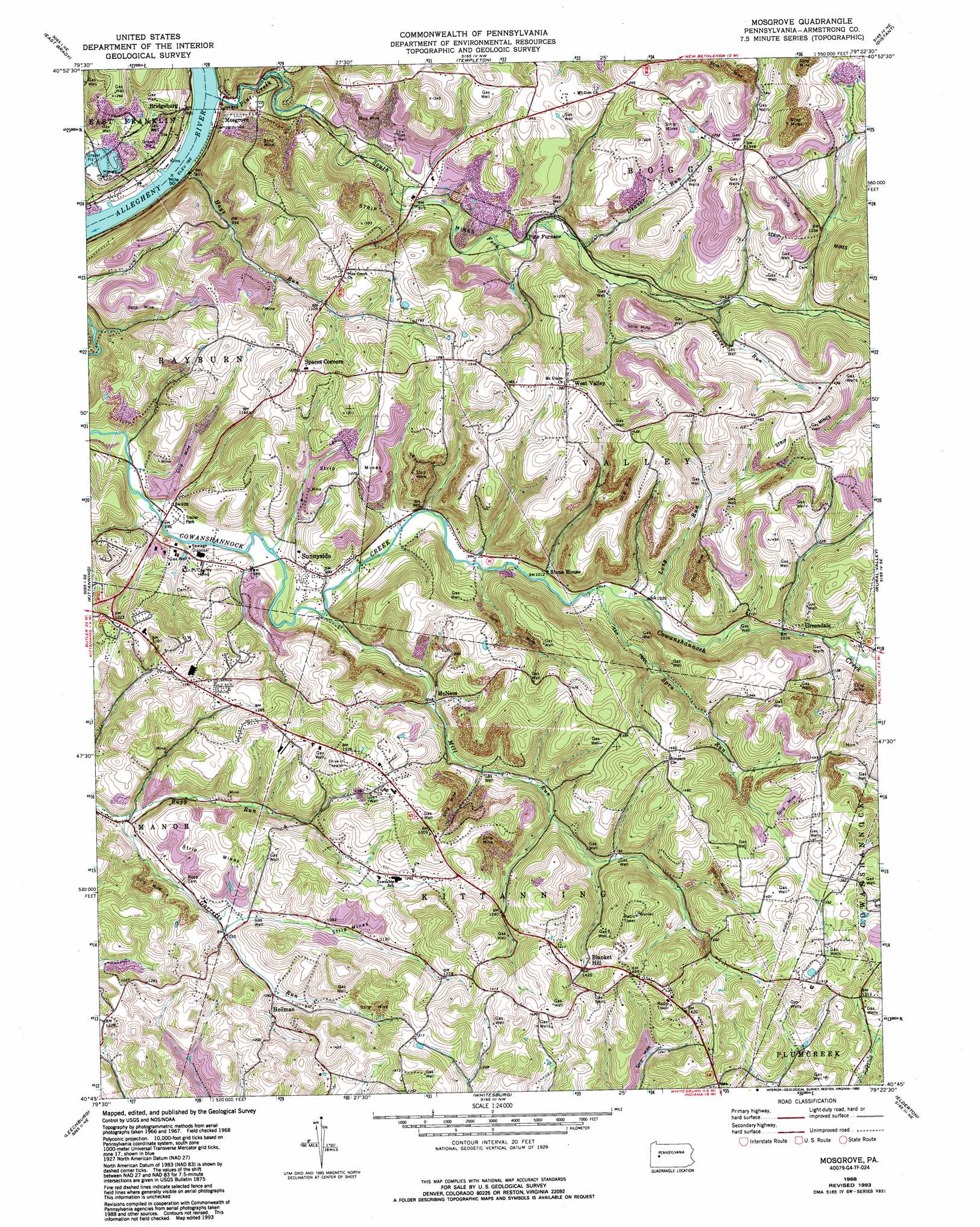
Mosgrove Topo Map Pennsylvania
To zoom in, hover over the map of Mosgrove
USGS Topo Quad 40079g4 - 1:24,000 scale
| Topo Map Name: | Mosgrove |
| USGS Topo Quad ID: | 40079g4 |
| Print Size: | ca. 21 1/4" wide x 27" high |
| Southeast Coordinates: | 40.75° N latitude / 79.375° W longitude |
| Map Center Coordinates: | 40.8125° N latitude / 79.4375° W longitude |
| U.S. State: | PA |
| Filename: | o40079g4.jpg |
| Download Map JPG Image: | Mosgrove topo map 1:24,000 scale |
| Map Type: | Topographic |
| Topo Series: | 7.5´ |
| Map Scale: | 1:24,000 |
| Source of Map Images: | United States Geological Survey (USGS) |
| Alternate Map Versions: |
Mosgrove PA 1968, updated 1972 Download PDF Buy paper map Mosgrove PA 1968, updated 1975 Download PDF Buy paper map Mosgrove PA 1968, updated 1979 Download PDF Buy paper map Mosgrove PA 1968, updated 1993 Download PDF Buy paper map Mosgrove PA 2010 Download PDF Buy paper map Mosgrove PA 2013 Download PDF Buy paper map Mosgrove PA 2016 Download PDF Buy paper map |
1:24,000 Topo Quads surrounding Mosgrove
Parker |
Rimersburg |
Sligo |
New Bethlehem |
Summerville |
Chicora |
East Brady |
Templeton |
Distant |
Dayton |
Worthington |
Kittanning |
Mosgrove |
Rural Valley |
Plumville |
Freeport |
Leechburg |
Whitesburg |
Elderton |
Ernest |
New Kensington East |
Vandergrift |
Avonmore |
Mcintyre |
Indiana |
> Back to 40079e1 at 1:100,000 scale
> Back to 40078a1 at 1:250,000 scale
> Back to U.S. Topo Maps home
Mosgrove topo map: Gazetteer
Mosgrove: Airports
Dunbar Airport elevation 444m 1456′Mosgrove: Populated Places
Blanket Hill elevation 429m 1407′Bridgeburg elevation 259m 849′
Green Acres elevation 302m 990′
Greendale elevation 326m 1069′
Heilman elevation 332m 1089′
McNees elevation 318m 1043′
Mosgrove elevation 296m 971′
Pine Furnace elevation 290m 951′
Spaces Corners elevation 397m 1302′
Sunnyside elevation 306m 1003′
West Valley elevation 418m 1371′
Mosgrove: Post Offices
Blanket Hill Post Office (historical) elevation 431m 1414′Mosgrove: Streams
Deaver Run elevation 297m 974′Hays Run elevation 245m 803′
Laurel Run elevation 316m 1036′
Long Run elevation 311m 1020′
Mill Run elevation 293m 961′
North Fork Pine Creek elevation 249m 816′
Pine Creek elevation 243m 797′
Rupp Run elevation 279m 915′
South Fork Pine Creek elevation 249m 816′
Spra Run elevation 306m 1003′
Mosgrove digital topo map on disk
Buy this Mosgrove topo map showing relief, roads, GPS coordinates and other geographical features, as a high-resolution digital map file on DVD:
 map DVD")