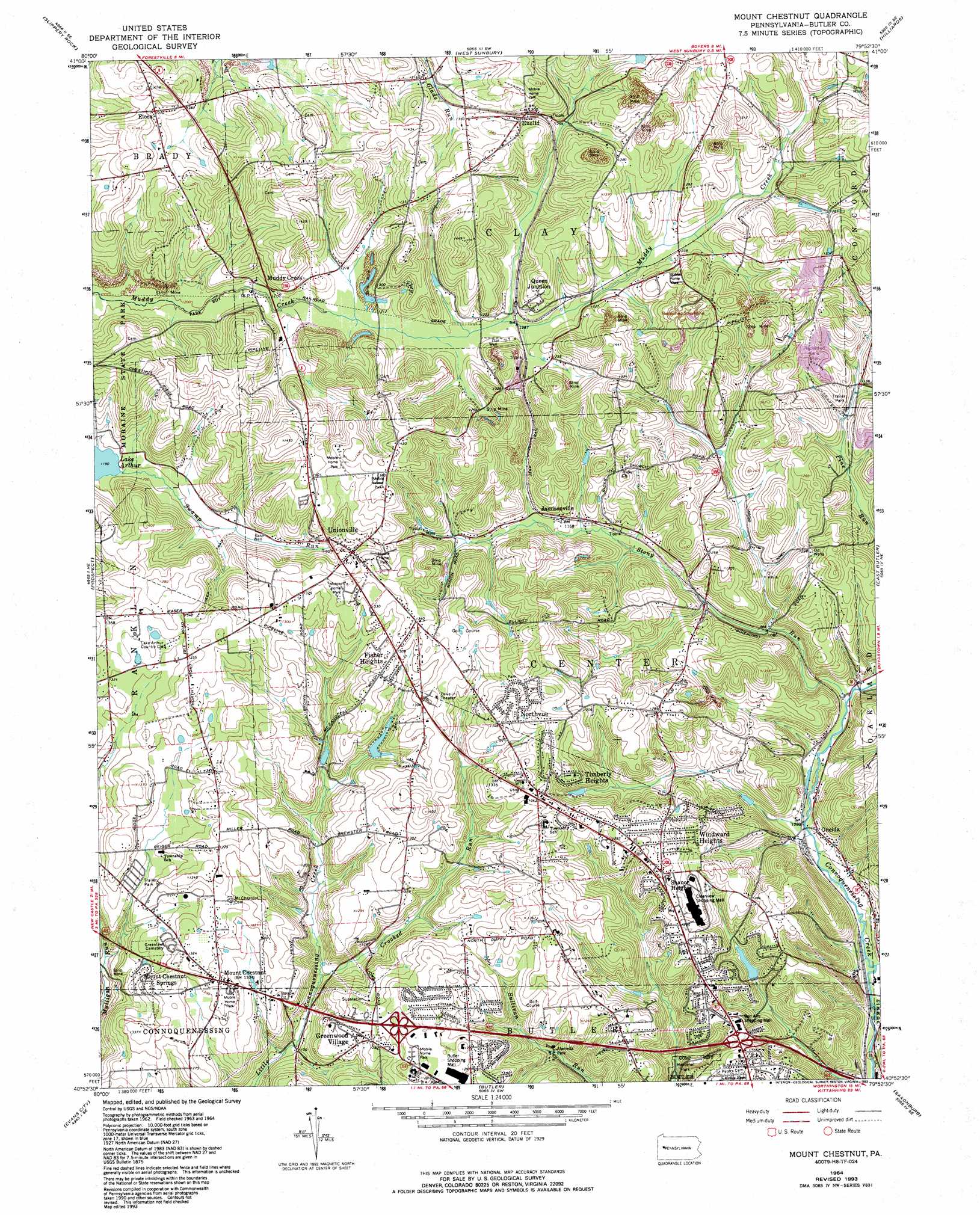
Mount Chestnut Topo Map Pennsylvania
To zoom in, hover over the map of Mount Chestnut
USGS Topo Quad 40079h8 - 1:24,000 scale
| Topo Map Name: | Mount Chestnut |
| USGS Topo Quad ID: | 40079h8 |
| Print Size: | ca. 21 1/4" wide x 27" high |
| Southeast Coordinates: | 40.875° N latitude / 79.875° W longitude |
| Map Center Coordinates: | 40.9375° N latitude / 79.9375° W longitude |
| U.S. State: | PA |
| Filename: | o40079h8.jpg |
| Download Map JPG Image: | Mount Chestnut topo map 1:24,000 scale |
| Map Type: | Topographic |
| Topo Series: | 7.5´ |
| Map Scale: | 1:24,000 |
| Source of Map Images: | United States Geological Survey (USGS) |
| Alternate Map Versions: |
Mount Chestnut PA 1964, updated 1965 Download PDF Buy paper map Mount Chestnut PA 1964, updated 1973 Download PDF Buy paper map Mount Chestnut PA 1964, updated 1990 Download PDF Buy paper map Mount Chestnut PA 1964, updated 1993 Download PDF Buy paper map Mount Chestnut PA 2010 Download PDF Buy paper map Mount Chestnut PA 2013 Download PDF Buy paper map Mount Chestnut PA 2016 Download PDF Buy paper map |
1:24,000 Topo Quads surrounding Mount Chestnut
Mercer |
Grove City |
Barkeyville |
Eau Claire |
Emlenton |
Harlansburg |
Slippery Rock |
West Sunbury |
Hilliards |
Parker |
Portersville |
Prospect |
Mount Chestnut |
East Butler |
Chicora |
Zelienople |
Evans City |
Butler |
Saxonburg |
Worthington |
Baden |
Mars |
Valencia |
Curtisville |
Freeport |
> Back to 40079e1 at 1:100,000 scale
> Back to 40078a1 at 1:250,000 scale
> Back to U.S. Topo Maps home
Mount Chestnut topo map: Gazetteer
Mount Chestnut: Airports
McCandless Airport elevation 404m 1325′Mount Chestnut: Dams
Thorn Run Dam elevation 394m 1292′Mount Chestnut: Populated Places
Elora elevation 419m 1374′Euclid elevation 407m 1335′
Fisher Heights elevation 406m 1332′
Greenwood Village elevation 388m 1272′
Jamisonville elevation 359m 1177′
Mount Chestnut elevation 404m 1325′
Mount Chestnut Springs elevation 399m 1309′
Muddy Creek elevation 372m 1220′
North Fork elevation 320m 1049′
Northvue elevation 420m 1377′
Oneida elevation 313m 1026′
Queen Junction elevation 391m 1282′
Shanor Heights elevation 404m 1325′
Smithville elevation 377m 1236′
Timberly Heights elevation 399m 1309′
Unionville elevation 385m 1263′
Windward Heights elevation 411m 1348′
Mount Chestnut: Reservoirs
Thorn Run Reservoir elevation 394m 1292′Mount Chestnut: Streams
Big Run elevation 371m 1217′Crooked Run elevation 335m 1099′
Stony Run elevation 313m 1026′
Thorn Creek elevation 305m 1000′
Mount Chestnut digital topo map on disk
Buy this Mount Chestnut topo map showing relief, roads, GPS coordinates and other geographical features, as a high-resolution digital map file on DVD:
 map DVD")