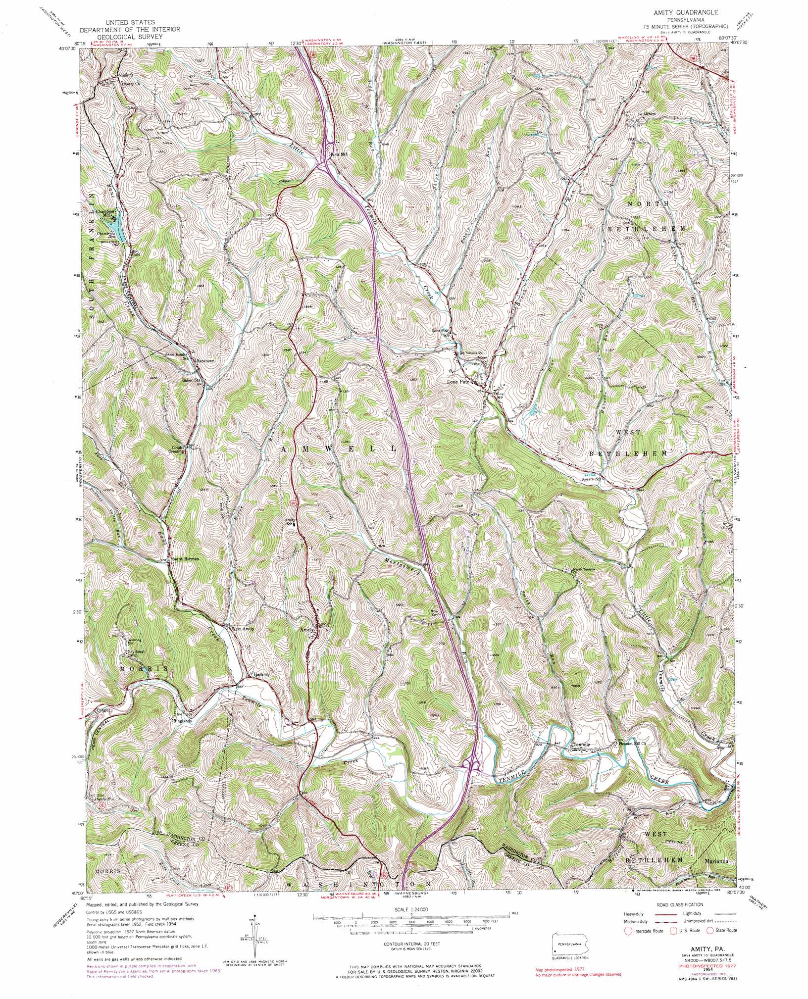
Amity Topo Map Pennsylvania
To zoom in, hover over the map of Amity
USGS Topo Quad 40080a2 - 1:24,000 scale
| Topo Map Name: | Amity |
| USGS Topo Quad ID: | 40080a2 |
| Print Size: | ca. 21 1/4" wide x 27" high |
| Southeast Coordinates: | 40° N latitude / 80.125° W longitude |
| Map Center Coordinates: | 40.0625° N latitude / 80.1875° W longitude |
| U.S. State: | PA |
| Filename: | o40080a2.jpg |
| Download Map JPG Image: | Amity topo map 1:24,000 scale |
| Map Type: | Topographic |
| Topo Series: | 7.5´ |
| Map Scale: | 1:24,000 |
| Source of Map Images: | United States Geological Survey (USGS) |
| Alternate Map Versions: |
Amity PA 1954, updated 1955 Download PDF Buy paper map Amity PA 1954, updated 1965 Download PDF Buy paper map Amity PA 1954, updated 1969 Download PDF Buy paper map Amity PA 1954, updated 1983 Download PDF Buy paper map Amity PA 1954, updated 1983 Download PDF Buy paper map Amity PA 2010 Download PDF Buy paper map Amity PA 2013 Download PDF Buy paper map Amity PA 2016 Download PDF Buy paper map |
1:24,000 Topo Quads surrounding Amity
Avella |
Midway |
Canonsburg |
Bridgeville |
Glassport |
West Middletown |
Washington West |
Washington East |
Hackett |
Monongahela |
Claysville |
Prosperity |
Amity |
Ellsworth |
California |
Wind Ridge |
Rogersville |
Waynesburg |
Mather |
Carmichaels |
New Freeport |
Holbrook |
Oak Forest |
Garards Fort |
Masontown |
> Back to 40080a1 at 1:100,000 scale
> Back to 40080a1 at 1:250,000 scale
> Back to U.S. Topo Maps home
Amity topo map: Gazetteer
Amity: Dams
Chambers Dam elevation 343m 1125′Amity: Mines
Moore Shaft elevation 296m 971′Amity: Populated Places
Amity elevation 366m 1200′Baker Station elevation 311m 1020′
Bakers elevation 394m 1292′
Banetown elevation 309m 1013′
Bissell elevation 278m 912′
Chambers Mill elevation 337m 1105′
Condit Crossing elevation 308m 1010′
Conger elevation 299m 980′
Hackney elevation 298m 977′
Lone Pine elevation 298m 977′
Long Pine elevation 399m 1309′
McCracken elevation 380m 1246′
Mount Herman elevation 302m 990′
Ringlands elevation 305m 1000′
Ten Mile elevation 279m 915′
Vankirk elevation 406m 1332′
West Amity elevation 295m 967′
Amity: Post Offices
Strabane Post Office (historical) elevation 339m 1112′Amity: Streams
Bane Creek elevation 290m 951′Brush Run elevation 300m 984′
Fork of Bane Creek elevation 300m 984′
Hainers Run elevation 292m 958′
Horne Run elevation 302m 990′
Hufford Run elevation 281m 921′
Little Tenmile Creek elevation 276m 905′
Montgomery Run elevation 300m 984′
Pine Run elevation 300m 984′
Pleasant Valley Run elevation 301m 987′
Potato Run elevation 311m 1020′
Redd Run elevation 298m 977′
Shipe Run elevation 304m 997′
Smith Run elevation 286m 938′
Amity digital topo map on disk
Buy this Amity topo map showing relief, roads, GPS coordinates and other geographical features, as a high-resolution digital map file on DVD:
 map DVD")