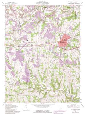
St Clairsville Topo Map Ohio
To zoom in, hover over the map of St Clairsville
USGS Topo Quad 40080a8 - 1:24,000 scale
| Topo Map Name: | St Clairsville |
| USGS Topo Quad ID: | 40080a8 |
| Print Size: | ca. 21 1/4" wide x 27" high |
| Southeast Coordinates: | 40° N latitude / 80.875° W longitude |
| Map Center Coordinates: | 40.0625° N latitude / 80.9375° W longitude |
| U.S. State: | OH |
| Filename: | o40080a8.jpg |
| Download Map JPG Image: | St Clairsville topo map 1:24,000 scale |
| Map Type: | Topographic |
| Topo Series: | 7.5´ |
| Map Scale: | 1:24,000 |
| Source of Map Images: | United States Geological Survey (USGS) |
| Alternate Map Versions: |
St. Clairsville OH 1960, updated 1961 Download PDF Buy paper map St. Clairsville OH 1960, updated 1972 Download PDF Buy paper map St. Clairsville OH 1960, updated 1973 Download PDF Buy paper map St. Clairsville OH 1960, updated 1978 Download PDF Buy paper map St. Clairsville OH 1960, updated 1985 Download PDF Buy paper map Saint Clairsville OH 2010 Download PDF Buy paper map Saint Clairsville OH 2013 Download PDF Buy paper map Saint Clairsville OH 2016 Download PDF Buy paper map |
1:24,000 Topo Quads surrounding St Clairsville
> Back to 40080a1 at 1:100,000 scale
> Back to 40080a1 at 1:250,000 scale
> Back to U.S. Topo Maps home
St Clairsville topo map: Gazetteer
St Clairsville: Airports
Alderman Airport elevation 360m 1181′Bannock Heliport elevation 337m 1105′
Twin Ash Airport elevation 368m 1207′
St Clairsville: Crossings
Interchange 213 elevation 355m 1164′Interchange 215 elevation 359m 1177′
Interchange 216 elevation 360m 1181′
Interchange 77 elevation 359m 1177′
St Clairsville: Dams
R and F Coal Fresh Water Dam elevation 299m 980′St Clairsville: Parks
Memorial Park elevation 357m 1171′St Clairsville: Populated Places
Bannock elevation 305m 1000′Blainesville elevation 263m 862′
Crabapple elevation 294m 964′
Donnersville elevation 355m 1164′
East Richland elevation 356m 1167′
Fairpoint elevation 290m 951′
Glencoe elevation 255m 836′
Great Western elevation 376m 1233′
Highland Terrace elevation 342m 1122′
Homeside elevation 356m 1167′
Lamira elevation 322m 1056′
Lloydsville elevation 359m 1177′
Maynard elevation 265m 869′
Midway elevation 306m 1003′
Oco elevation 326m 1069′
Provident elevation 320m 1049′
Saint Clairsville elevation 388m 1272′
Warnock elevation 284m 931′
Whitney elevation 275m 902′
St Clairsville: Post Offices
Bannock Post Office elevation 300m 984′East Richland Post Office (historical) elevation 356m 1167′
Fairpoint Post Office elevation 281m 921′
Glencoe Post Office elevation 256m 839′
Lamira Post Office (historical) elevation 309m 1013′
Lloydsville Post Office (historical) elevation 359m 1177′
Maynard Post Office elevation 258m 846′
Saint Clairsville Post Office elevation 390m 1279′
Warnock Post Office elevation 283m 928′
Whitney Post Office (historical) elevation 276m 905′
St Clairsville: Reservoirs
R and F Coal Fresh Water Impoundment elevation 299m 980′Saint Clairsville Reservoir Number One elevation 341m 1118′
Saint Clairsville Reservoir Number Two elevation 324m 1062′
St Clairsville: Streams
Anderson Run elevation 293m 961′Brush Run elevation 289m 948′
Chambers Run elevation 312m 1023′
Cox Run elevation 273m 895′
Crabapple Creek elevation 283m 928′
Cumberland Run elevation 248m 813′
Hutchison Run elevation 280m 918′
Jug Run elevation 255m 836′
Loves Run elevation 271m 889′
McCracken Run elevation 284m 931′
Neffs Run elevation 283m 928′
Pogue Run elevation 270m 885′
Porterfield Run elevation 271m 889′
Roberts Run elevation 301m 987′
Sloan Run elevation 256m 839′
Welsh Run elevation 252m 826′
Williams Creek elevation 252m 826′
St Clairsville: Summits
Chapel Hill elevation 415m 1361′Clark Hill elevation 414m 1358′
Galloway Knob elevation 414m 1358′
St Clairsville: Valleys
Coaly Hollow elevation 270m 885′Wheeling Valley elevation 255m 836′
St Clairsville digital topo map on disk
Buy this St Clairsville topo map showing relief, roads, GPS coordinates and other geographical features, as a high-resolution digital map file on DVD:


