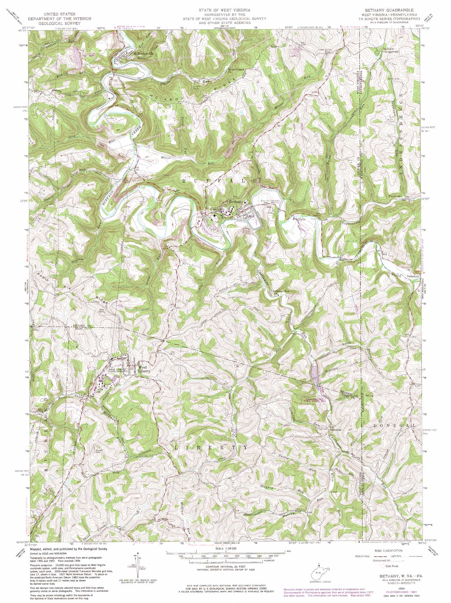
Bethany Topo Map West Virginia
To zoom in, hover over the map of Bethany
USGS Topo Quad 40080b5 - 1:24,000 scale
| Topo Map Name: | Bethany |
| USGS Topo Quad ID: | 40080b5 |
| Print Size: | ca. 21 1/4" wide x 27" high |
| Southeast Coordinates: | 40.125° N latitude / 80.5° W longitude |
| Map Center Coordinates: | 40.1875° N latitude / 80.5625° W longitude |
| U.S. States: | WV, PA |
| Filename: | o40080b5.jpg |
| Download Map JPG Image: | Bethany topo map 1:24,000 scale |
| Map Type: | Topographic |
| Topo Series: | 7.5´ |
| Map Scale: | 1:24,000 |
| Source of Map Images: | United States Geological Survey (USGS) |
| Alternate Map Versions: |
Bethany WV 1959, updated 1961 Download PDF Buy paper map Bethany WV 1959, updated 1969 Download PDF Buy paper map Bethany WV 1959, updated 1982 Download PDF Buy paper map Bethany WV 1997, updated 2000 Download PDF Buy paper map Bethany WV 2010 Download PDF Buy paper map Bethany WV 2014 Download PDF Buy paper map Bethany WV 2016 Download PDF Buy paper map |
1:24,000 Topo Quads surrounding Bethany
Richmond |
Knoxville |
Weirton |
Burgettstown |
Clinton |
Smithfield |
Steubenville West |
Steubenville East |
Avella |
Midway |
Dillonvale |
Tiltonsville |
Bethany |
West Middletown |
Washington West |
Lansing |
Wheeling |
Valley Grove |
Claysville |
Prosperity |
Businessburg |
Moundsville |
Majorsville |
Wind Ridge |
Rogersville |
> Back to 40080a1 at 1:100,000 scale
> Back to 40080a1 at 1:250,000 scale
> Back to U.S. Topo Maps home
Bethany topo map: Gazetteer
Bethany: Dams
Castlemans Run Lake Dam elevation 293m 961′Bethany: Parks
Castleman Run Wildlife Management Area elevation 285m 935′Bethany: Populated Places
Bethany elevation 258m 846′Dunsfort elevation 266m 872′
Frogtown elevation 275m 902′
McKinleyville elevation 208m 682′
Potomac elevation 294m 964′
West Liberty elevation 373m 1223′
Bethany: Ridges
Apple Pie Ridge elevation 407m 1335′McAdoo Ridge elevation 374m 1227′
Bethany: Springs
Asher Childers Spring elevation 376m 1233′Bauer Spring elevation 354m 1161′
Charles E Hunt Spring elevation 357m 1171′
Court Spring elevation 362m 1187′
Earl D McKay Spring elevation 368m 1207′
Fred Foster Spring elevation 363m 1190′
Harden Spring elevation 326m 1069′
Herbert Minch Spring elevation 408m 1338′
Howard Bachman Spring elevation 384m 1259′
Hunt Spring elevation 348m 1141′
Irwin Roger Spring elevation 342m 1122′
James Loew Spring elevation 399m 1309′
Lawrence Sonda Spring elevation 351m 1151′
Leo Miller Spring elevation 338m 1108′
Melvin Dayton Spring elevation 371m 1217′
Sanford Midcap Spring elevation 395m 1295′
William Summerville Spring elevation 383m 1256′
Bethany: Streams
Blayney Run elevation 315m 1033′Brashears Run elevation 278m 912′
Camp Run elevation 249m 816′
Camp Run elevation 249m 816′
Cascade Run elevation 244m 800′
Castleman Run elevation 241m 790′
Castleman Run elevation 241m 790′
Crupe Run elevation 301m 987′
Crupe Run elevation 301m 987′
Curtis Run elevation 305m 1000′
Dog Run elevation 256m 839′
Ferry Run elevation 236m 774′
Garrison Run elevation 293m 961′
Grog Run elevation 225m 738′
Hogtan Run elevation 226m 741′
Hukill Run elevation 223m 731′
Kimlin Run elevation 215m 705′
Logan Run elevation 239m 784′
Longs Run elevation 267m 875′
Mingo Run elevation 221m 725′
Murray Run elevation 310m 1017′
North Prong elevation 279m 915′
North Prong Castleman Run elevation 276m 905′
Pierce Run elevation 210m 688′
Rices Run elevation 297m 974′
Rices Run elevation 297m 974′
Stotts Run elevation 233m 764′
Sugarcamp Run elevation 251m 823′
Sugarcamp Run elevation 251m 823′
Titt Run elevation 204m 669′
Weidman Run elevation 293m 961′
Welch Run elevation 255m 836′
Bethany: Valleys
Welch Hollow elevation 255m 836′Bethany digital topo map on disk
Buy this Bethany topo map showing relief, roads, GPS coordinates and other geographical features, as a high-resolution digital map file on DVD:
 map DVD")