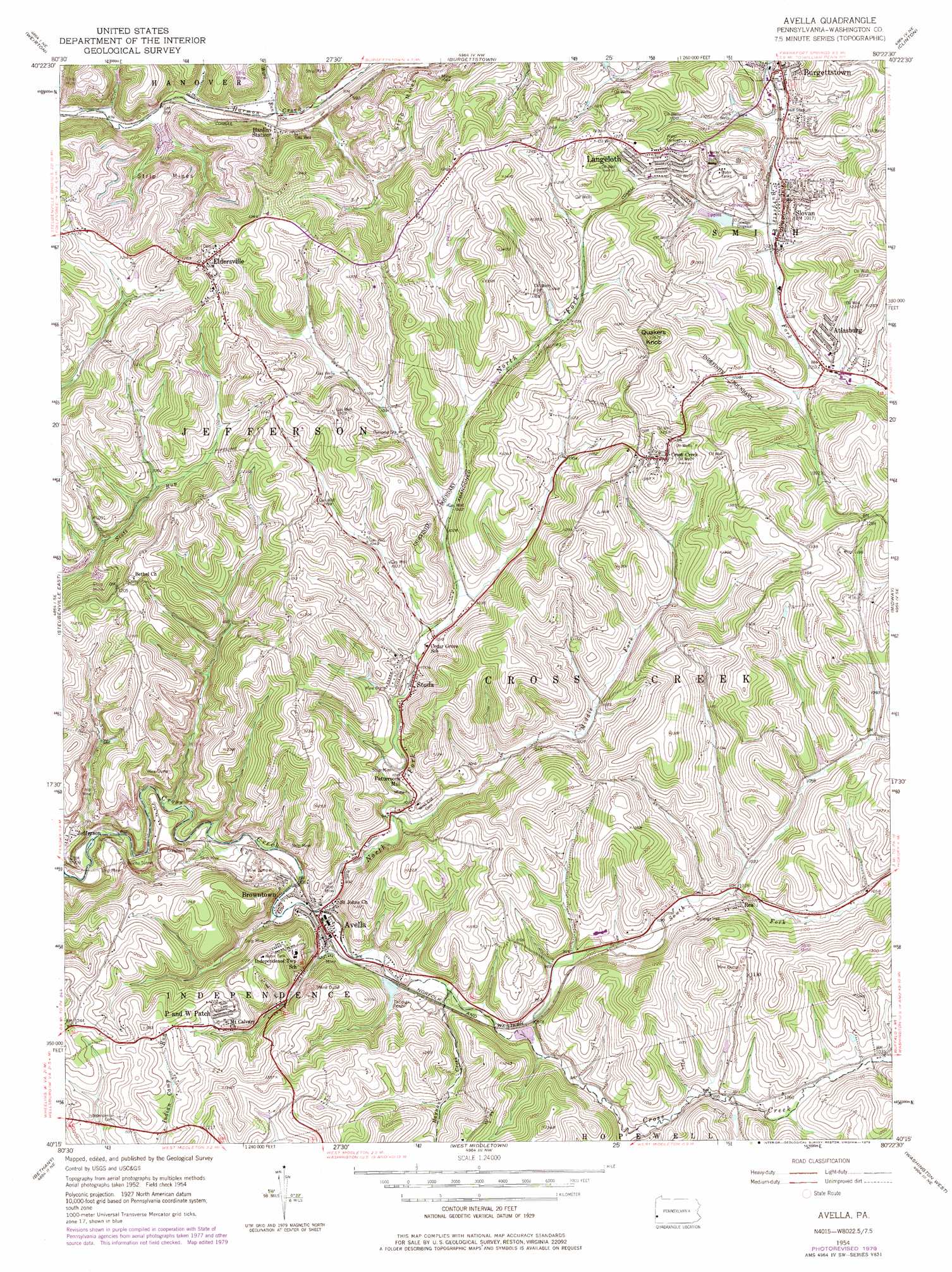
Avella Topo Map Pennsylvania
To zoom in, hover over the map of Avella
USGS Topo Quad 40080c4 - 1:24,000 scale
| Topo Map Name: | Avella |
| USGS Topo Quad ID: | 40080c4 |
| Print Size: | ca. 21 1/4" wide x 27" high |
| Southeast Coordinates: | 40.25° N latitude / 80.375° W longitude |
| Map Center Coordinates: | 40.3125° N latitude / 80.4375° W longitude |
| U.S. State: | PA |
| Filename: | o40080c4.jpg |
| Download Map JPG Image: | Avella topo map 1:24,000 scale |
| Map Type: | Topographic |
| Topo Series: | 7.5´ |
| Map Scale: | 1:24,000 |
| Source of Map Images: | United States Geological Survey (USGS) |
| Alternate Map Versions: |
Avella PA 1954, updated 1955 Download PDF Buy paper map Avella PA 1954, updated 1969 Download PDF Buy paper map Avella PA 1954, updated 1979 Download PDF Buy paper map Avella PA 2010 Download PDF Buy paper map Avella PA 2013 Download PDF Buy paper map Avella PA 2016 Download PDF Buy paper map |
1:24,000 Topo Quads surrounding Avella
Wellsville |
East Liverpool South |
Hookstown |
Aliquippa |
Ambridge |
Knoxville |
Weirton |
Burgettstown |
Clinton |
Oakdale |
Steubenville West |
Steubenville East |
Avella |
Midway |
Canonsburg |
Tiltonsville |
Bethany |
West Middletown |
Washington West |
Washington East |
Wheeling |
Valley Grove |
Claysville |
Prosperity |
Amity |
> Back to 40080a1 at 1:100,000 scale
> Back to 40080a1 at 1:250,000 scale
> Back to U.S. Topo Maps home
Avella topo map: Gazetteer
Avella: Dams
Flood Dam 485 elevation 271m 889′PA-479 Dam elevation 278m 912′
Pa-480 Dam elevation 336m 1102′
Pa-484 Dam elevation 298m 977′
Pa-485 Dam elevation 265m 869′
Zinc Dam elevation 321m 1053′
Avella: Parks
Cross Creek County Park elevation 301m 987′Hill Stadium elevation 305m 1000′
State Game Lands Number 303 elevation 297m 974′
Avella: Populated Places
Atlasburg elevation 330m 1082′Avella elevation 279m 915′
Avella Highlands elevation 359m 1177′
Browntown elevation 279m 915′
Cross Creek elevation 409m 1341′
Eldersville elevation 404m 1325′
Hanlin Station elevation 285m 935′
Jefferson elevation 294m 964′
Langeloth elevation 372m 1220′
P and W Patch elevation 354m 1161′
Pattersons Mill elevation 312m 1023′
Rea elevation 329m 1079′
Slovan elevation 317m 1040′
Studa elevation 307m 1007′
West Middletown (historical) elevation 300m 984′
Avella: Post Offices
Atlasburg Post Office elevation 317m 1040′Langeloth Post Office elevation 369m 1210′
Slovan Post Office elevation 313m 1026′
Avella: Reservoirs
Zinc Dam Reservoir elevation 321m 1053′Avella: Streams
Haynan Creek elevation 286m 938′Middle Fork Cross Creek elevation 294m 964′
North Fork Cross Creek elevation 271m 889′
South Fork Cross Creek elevation 294m 964′
Ward Run elevation 278m 912′
Avella: Summits
Quakers Knob elevation 443m 1453′Avella: Tunnels
Bixton Tunnel elevation 282m 925′Craighead Tunnel elevation 301m 987′
Avella digital topo map on disk
Buy this Avella topo map showing relief, roads, GPS coordinates and other geographical features, as a high-resolution digital map file on DVD:
 map DVD")