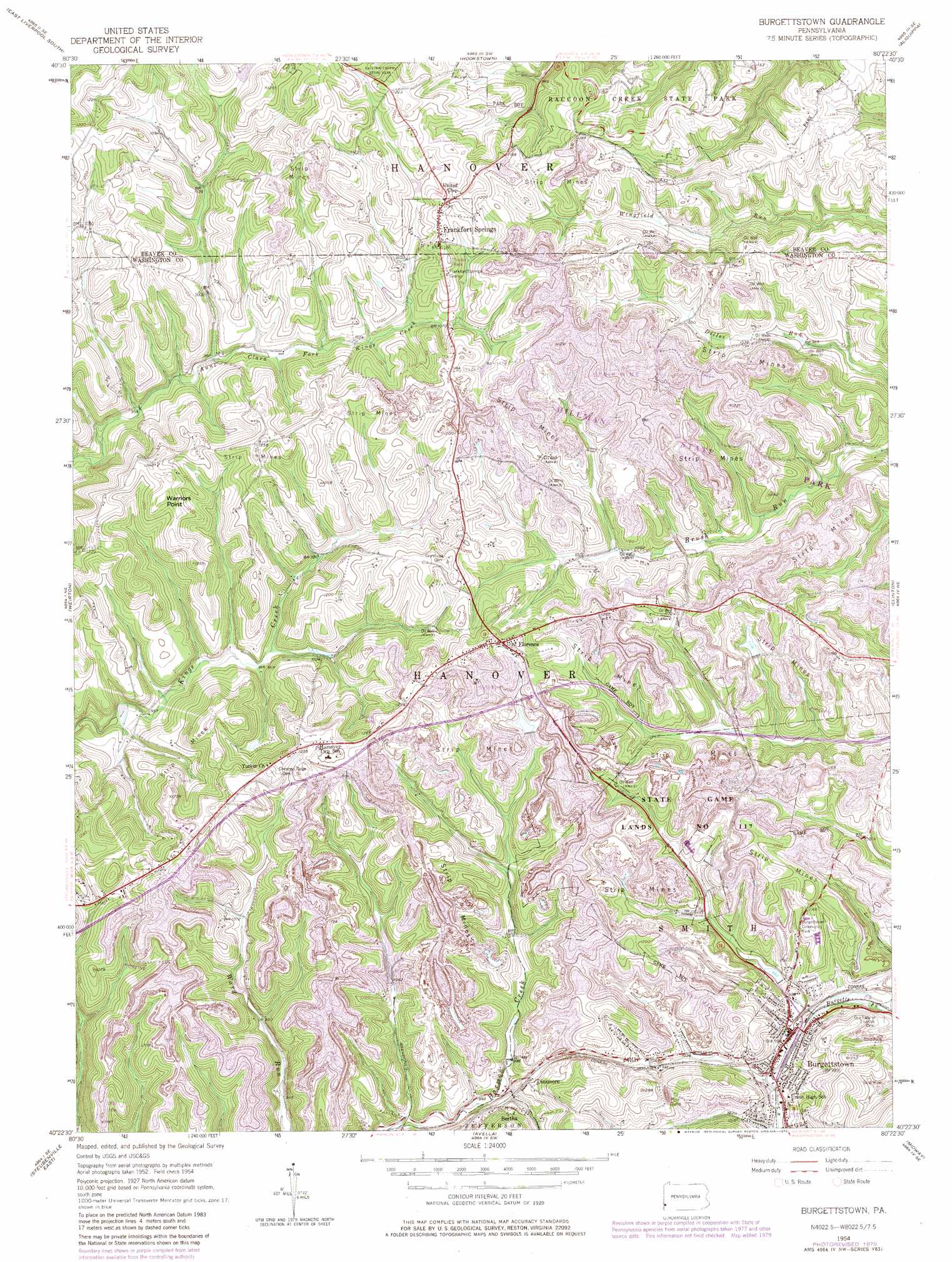
Burgettstown Topo Map Pennsylvania
To zoom in, hover over the map of Burgettstown
USGS Topo Quad 40080d4 - 1:24,000 scale
| Topo Map Name: | Burgettstown |
| USGS Topo Quad ID: | 40080d4 |
| Print Size: | ca. 21 1/4" wide x 27" high |
| Southeast Coordinates: | 40.375° N latitude / 80.375° W longitude |
| Map Center Coordinates: | 40.4375° N latitude / 80.4375° W longitude |
| U.S. State: | PA |
| Filename: | o40080d4.jpg |
| Download Map JPG Image: | Burgettstown topo map 1:24,000 scale |
| Map Type: | Topographic |
| Topo Series: | 7.5´ |
| Map Scale: | 1:24,000 |
| Source of Map Images: | United States Geological Survey (USGS) |
| Alternate Map Versions: |
Burgettstown PA 1954, updated 1955 Download PDF Buy paper map Burgettstown PA 1954, updated 1965 Download PDF Buy paper map Burgettstown PA 1954, updated 1969 Download PDF Buy paper map Burgettstown PA 1954, updated 1979 Download PDF Buy paper map Burgettstown PA 1954, updated 1979 Download PDF Buy paper map Burgettstown PA 1954, updated 1979 Download PDF Buy paper map Burgettstown PA 2010 Download PDF Buy paper map Burgettstown PA 2013 Download PDF Buy paper map Burgettstown PA 2016 Download PDF Buy paper map |
1:24,000 Topo Quads surrounding Burgettstown
West Point |
East Liverpool North |
Midland |
Beaver |
Baden |
Wellsville |
East Liverpool South |
Hookstown |
Aliquippa |
Ambridge |
Knoxville |
Weirton |
Burgettstown |
Clinton |
Oakdale |
Steubenville West |
Steubenville East |
Avella |
Midway |
Canonsburg |
Tiltonsville |
Bethany |
West Middletown |
Washington West |
Washington East |
> Back to 40080a1 at 1:100,000 scale
> Back to 40080a1 at 1:250,000 scale
> Back to U.S. Topo Maps home
Burgettstown topo map: Gazetteer
Burgettstown: Airports
Bologna Heliport elevation 364m 1194′Miller Airport elevation 363m 1190′
Burgettstown: Cliffs
Warriors Point elevation 389m 1276′Burgettstown: Dams
Dinsmore Storage Number Two Dam elevation 310m 1017′Flood Dam 482 elevation 342m 1122′
Flood Dam 483 elevation 338m 1108′
Pa-483 Dam elevation 309m 1013′
Burgettstown: Parks
Burgettstown Community Park elevation 351m 1151′State Game Lands Number 117 elevation 343m 1125′
Burgettstown: Populated Places
Bertha elevation 337m 1105′Burgettstown elevation 302m 990′
Comettsburg elevation 339m 1112′
Dinsmore elevation 334m 1095′
Florence elevation 390m 1279′
Frankfort Springs elevation 351m 1151′
Burgettstown: Reservoirs
Dinsmore Reservoir elevation 310m 1017′Burgettstown: Springs
Frankfort Springs elevation 321m 1053′Burgettstown: Valleys
Martin Hollow elevation 316m 1036′Burgettstown digital topo map on disk
Buy this Burgettstown topo map showing relief, roads, GPS coordinates and other geographical features, as a high-resolution digital map file on DVD:
 map DVD")