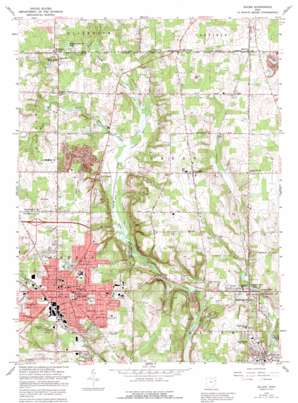
Salem Topo Map Ohio
To zoom in, hover over the map of Salem
USGS Topo Quad 40080h7 - 1:24,000 scale
| Topo Map Name: | Salem |
| USGS Topo Quad ID: | 40080h7 |
| Print Size: | ca. 21 1/4" wide x 27" high |
| Southeast Coordinates: | 40.875° N latitude / 80.75° W longitude |
| Map Center Coordinates: | 40.9375° N latitude / 80.8125° W longitude |
| U.S. State: | OH |
| Filename: | o40080h7.jpg |
| Download Map JPG Image: | Salem topo map 1:24,000 scale |
| Map Type: | Topographic |
| Topo Series: | 7.5´ |
| Map Scale: | 1:24,000 |
| Source of Map Images: | United States Geological Survey (USGS) |
| Alternate Map Versions: |
Salem OH 1952, updated 1954 Download PDF Buy paper map Salem OH 1966, updated 1968 Download PDF Buy paper map Salem OH 1966, updated 1978 Download PDF Buy paper map Salem OH 1966, updated 1992 Download PDF Buy paper map Salem OH 1994, updated 1997 Download PDF Buy paper map Salem OH 2010 Download PDF Buy paper map Salem OH 2013 Download PDF Buy paper map Salem OH 2016 Download PDF Buy paper map |
1:24,000 Topo Quads surrounding Salem
> Back to 40080e1 at 1:100,000 scale
> Back to 40080a1 at 1:250,000 scale
> Back to U.S. Topo Maps home
Salem topo map: Gazetteer
Salem: Airports
Salem Airpark Inc Airport elevation 353m 1158′Salem Community Hospital Heliport elevation 398m 1305′
Salem: Canals
Callahan Ditch elevation 317m 1040′Goodman Ditch elevation 315m 1033′
Salem: Lakes
Cherry Valley Pond elevation 309m 1013′Copacia Lake elevation 364m 1194′
Dunn Eden Lake elevation 334m 1095′
Liberty Park Lake elevation 318m 1043′
Western Reserve Lake elevation 323m 1059′
Salem: Parks
Centennial Park elevation 392m 1286′Kelley Park elevation 380m 1246′
Township Park elevation 344m 1128′
Waterworth Memorial Park elevation 373m 1223′
Salem: Populated Places
Bowmans Corners elevation 334m 1095′Calla elevation 349m 1145′
Greenford elevation 377m 1236′
Hickory Corners elevation 328m 1076′
Knaufville elevation 333m 1092′
Leetonia elevation 310m 1017′
Locust Grove elevation 376m 1233′
Marquis elevation 344m 1128′
Millville elevation 317m 1040′
New Albany elevation 326m 1069′
Salem elevation 374m 1227′
Salem Mobile Home Park elevation 356m 1167′
Toots Corners elevation 361m 1184′
Washingtonville elevation 322m 1056′
Salem: Post Offices
Greenford Post Office elevation 378m 1240′Knaufville Post Office (historical) elevation 335m 1099′
Leetonia Post Office elevation 310m 1017′
New Albany Post Office (historical) elevation 328m 1076′
Salem Post Office elevation 378m 1240′
Washington Post Office elevation 324m 1062′
Salem: Swamps
New Albany Marsh elevation 313m 1026′Salem digital topo map on disk
Buy this Salem topo map showing relief, roads, GPS coordinates and other geographical features, as a high-resolution digital map file on DVD:


