Cambridge Topo Map Ohio
To zoom in, hover over the map of Cambridge
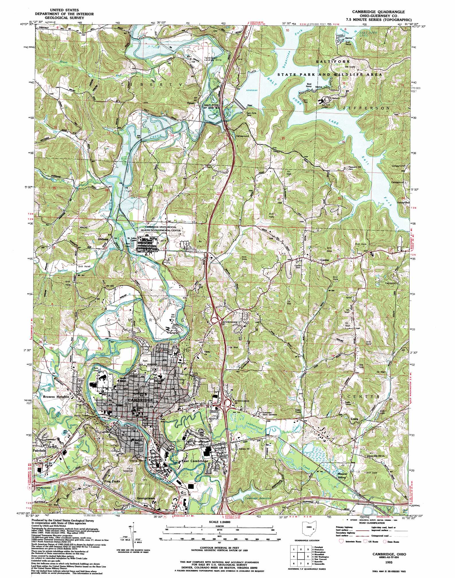
USGS Topo Quad 40081a5 - 1:24,000 scale
| Topo Map Name: | Cambridge |
| USGS Topo Quad ID: | 40081a5 |
| Print Size: | ca. 21 1/4" wide x 27" high |
| Southeast Coordinates: | 40° N latitude / 81.5° W longitude |
| Map Center Coordinates: | 40.0625° N latitude / 81.5625° W longitude |
| U.S. State: | OH |
| Filename: | o40081a5.jpg |
| Download Map JPG Image: | Cambridge topo map 1:24,000 scale |
| Map Type: | Topographic |
| Topo Series: | 7.5´ |
| Map Scale: | 1:24,000 |
| Source of Map Images: | United States Geological Survey (USGS) |
| Alternate Map Versions: |
Cambridge OH 1962, updated 1963 Download PDF Buy paper map Cambridge OH 1962, updated 1973 Download PDF Buy paper map Cambridge OH 1962, updated 1978 Download PDF Buy paper map Cambridge OH 1993, updated 1994 Download PDF Buy paper map Cambridge OH 1994, updated 1998 Download PDF Buy paper map Cambridge OH 2010 Download PDF Buy paper map Cambridge OH 2013 Download PDF Buy paper map Cambridge OH 2016 Download PDF Buy paper map |
1:24,000 Topo Quads surrounding Cambridge
Coshocton |
Fresno |
Newcomerstown |
Gnadenhutten |
Tippecanoe |
Wills Creek |
Plainfield |
Kimbolton |
Birmingham |
Freeport |
Otsego |
Bloomfield |
Cambridge |
Old Washington |
Antrim |
Norwich |
New Concord |
Byesville |
Senecaville |
Quaker City |
Ruraldale |
Cumberland |
Caldwell North |
Sarahsville |
Summerfield |
> Back to 40081a1 at 1:100,000 scale
> Back to 40080a1 at 1:250,000 scale
> Back to U.S. Topo Maps home
Cambridge topo map: Gazetteer
Cambridge: Airports
Salt Fork Lodge Heliport elevation 253m 830′Taildragger Airport elevation 245m 803′
Cambridge: Crossings
Interchange 176 elevation 248m 813′Interchange 46 elevation 244m 800′
Cambridge: Dams
Cambridge City Reservoir Dam elevation 258m 846′Culbertson Farm Lake Dam elevation 243m 797′
Salt Fork Reservoir Dam elevation 236m 774′
Salt Fort Dam elevation 241m 790′
Cambridge: Parks
Jack D Hendricks Memorial Park elevation 278m 912′Northside Park elevation 257m 843′
Wheeling Avenue Historic District elevation 266m 872′
Cambridge: Populated Places
Abledell elevation 257m 843′Barton Manor elevation 269m 882′
Black elevation 274m 898′
Browns Heights elevation 262m 859′
Cambridge elevation 253m 830′
Cedar Hills elevation 262m 859′
Center elevation 317m 1040′
Clio (historical) elevation 246m 807′
Coventry Estates elevation 286m 938′
Craig elevation 265m 869′
East Cambridge elevation 244m 800′
Eastmoor elevation 244m 800′
Fairdale elevation 262m 859′
Fairmont elevation 250m 820′
Five Forks elevation 270m 885′
Georgetown elevation 251m 823′
Henderson Heights elevation 268m 879′
Meadow Village elevation 268m 879′
Northgate elevation 245m 803′
Oldham elevation 241m 790′
Sunnymeade elevation 251m 823′
Sycamore Hills elevation 265m 869′
Tyner elevation 238m 780′
Cambridge: Post Offices
Cambridge Post Office elevation 272m 892′Clio Post Office (historical) elevation 250m 820′
Craig Post Office (historical) elevation 281m 921′
Oldham Post Office (historical) elevation 237m 777′
Tyner Post Office (historical) elevation 241m 790′
Cambridge: Reservoirs
Cambridge City Reservoir elevation 258m 846′Culbertson Farm Lake elevation 243m 797′
Salt Fork Lake elevation 241m 790′
Salt Fork Reservoir elevation 236m 774′
Cambridge: Streams
Brush Run elevation 232m 761′Crooked Creek elevation 236m 774′
Leatherwood Creek elevation 238m 780′
Mud Run elevation 249m 816′
Salt Fork elevation 241m 790′
Sarchet Run elevation 237m 777′
Sugartree Fork elevation 245m 803′
Cambridge digital topo map on disk
Buy this Cambridge topo map showing relief, roads, GPS coordinates and other geographical features, as a high-resolution digital map file on DVD:
 map DVD")