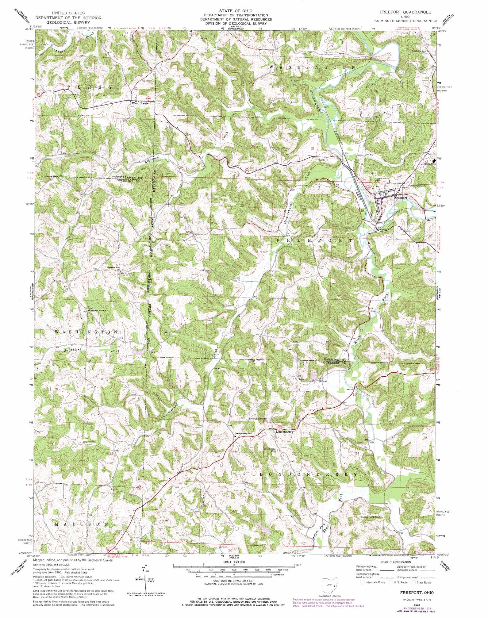
Freeport Topo Map Ohio
To zoom in, hover over the map of Freeport
USGS Topo Quad 40081b3 - 1:24,000 scale
| Topo Map Name: | Freeport |
| USGS Topo Quad ID: | 40081b3 |
| Print Size: | ca. 21 1/4" wide x 27" high |
| Southeast Coordinates: | 40.125° N latitude / 81.25° W longitude |
| Map Center Coordinates: | 40.1875° N latitude / 81.3125° W longitude |
| U.S. State: | OH |
| Filename: | o40081b3.jpg |
| Download Map JPG Image: | Freeport topo map 1:24,000 scale |
| Map Type: | Topographic |
| Topo Series: | 7.5´ |
| Map Scale: | 1:24,000 |
| Source of Map Images: | United States Geological Survey (USGS) |
| Alternate Map Versions: |
Freeport OH 1961, updated 1963 Download PDF Buy paper map Freeport OH 1961, updated 1963 Download PDF Buy paper map Freeport OH 1961, updated 1978 Download PDF Buy paper map Freeport OH 1994, updated 1998 Download PDF Buy paper map Freeport OH 2010 Download PDF Buy paper map Freeport OH 2013 Download PDF Buy paper map Freeport OH 2016 Download PDF Buy paper map |
1:24,000 Topo Quads surrounding Freeport
Stone Creek |
New Philadelphia |
Uhrichsville |
Bowerston |
Scio |
Newcomerstown |
Gnadenhutten |
Tippecanoe |
Deersville |
Jewett |
Kimbolton |
Birmingham |
Freeport |
Piedmont |
Flushing |
Cambridge |
Old Washington |
Antrim |
Fairview |
Bethesda |
Byesville |
Senecaville |
Quaker City |
Barnesville |
Hunter |
> Back to 40081a1 at 1:100,000 scale
> Back to 40080a1 at 1:250,000 scale
> Back to U.S. Topo Maps home
Freeport topo map: Gazetteer
Freeport: Bridges
Skull Fork Bridge elevation 268m 879′Freeport: Dams
Hidden Haven Lake Dam elevation 287m 941′Freeport: Mines
Crab Orchard Mine elevation 285m 935′Freeport: Populated Places
Freeport elevation 304m 997′Londonderry elevation 355m 1164′
West Chester elevation 353m 1158′
Freeport: Post Offices
Freeport Post Office elevation 305m 1000′Londonderry Post Office (historical) elevation 346m 1135′
Freeport: Reservoirs
Hidden Haven Lake elevation 287m 941′Freeport: Streams
Atkinson Creek elevation 262m 859′Bearman Run elevation 262m 859′
Craborchard Creek elevation 263m 862′
Millers Fork elevation 270m 885′
Skull Fork elevation 260m 853′
Small Atkinson Creek elevation 272m 892′
Freeport digital topo map on disk
Buy this Freeport topo map showing relief, roads, GPS coordinates and other geographical features, as a high-resolution digital map file on DVD:
 map DVD")