Mineral City Topo Map Ohio
To zoom in, hover over the map of Mineral City
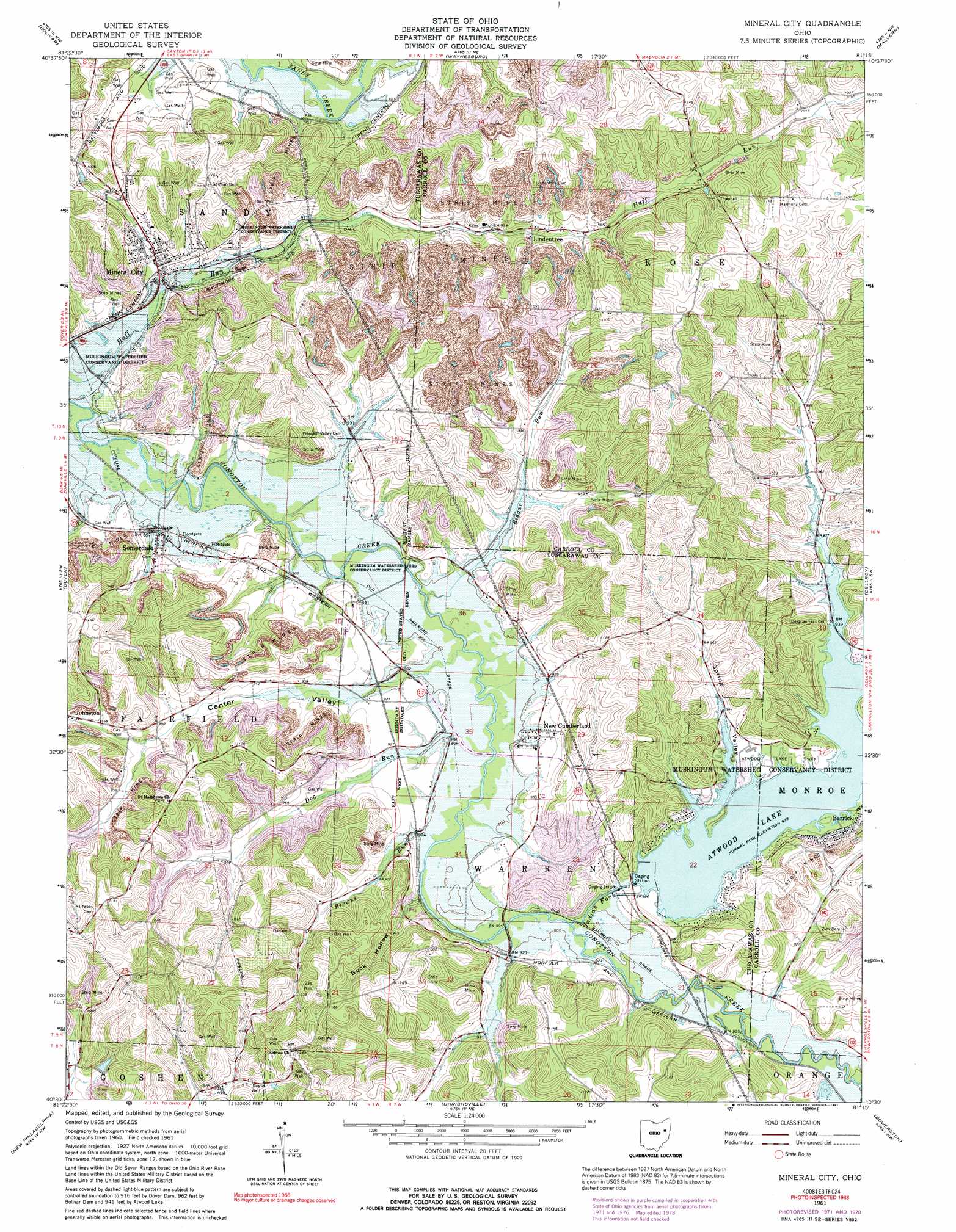
USGS Topo Quad 40081e3 - 1:24,000 scale
| Topo Map Name: | Mineral City |
| USGS Topo Quad ID: | 40081e3 |
| Print Size: | ca. 21 1/4" wide x 27" high |
| Southeast Coordinates: | 40.5° N latitude / 81.25° W longitude |
| Map Center Coordinates: | 40.5625° N latitude / 81.3125° W longitude |
| U.S. State: | OH |
| Filename: | o40081e3.jpg |
| Download Map JPG Image: | Mineral City topo map 1:24,000 scale |
| Map Type: | Topographic |
| Topo Series: | 7.5´ |
| Map Scale: | 1:24,000 |
| Source of Map Images: | United States Geological Survey (USGS) |
| Alternate Map Versions: |
Mineral City OH 1961, updated 1963 Download PDF Buy paper map Mineral City OH 1961, updated 1972 Download PDF Buy paper map Mineral City OH 1961, updated 1978 Download PDF Buy paper map Mineral City OH 1961, updated 1991 Download PDF Buy paper map Mineral City OH 1994, updated 1998 Download PDF Buy paper map Mineral City OH 2010 Download PDF Buy paper map Mineral City OH 2013 Download PDF Buy paper map Mineral City OH 2016 Download PDF Buy paper map |
1:24,000 Topo Quads surrounding Mineral City
Massillon |
Canton West |
Canton East |
Robertsville |
Homeworth |
Navarre |
Bolivar |
Waynesburg |
Malvern |
Minerva |
Strasburg |
Dover |
Mineral City |
Dellroy |
Carrollton |
Stone Creek |
New Philadelphia |
Uhrichsville |
Bowerston |
Scio |
Newcomerstown |
Gnadenhutten |
Tippecanoe |
Deersville |
Jewett |
> Back to 40081e1 at 1:100,000 scale
> Back to 40080a1 at 1:250,000 scale
> Back to U.S. Topo Maps home
Mineral City topo map: Gazetteer
Mineral City: Dams
Atwood Dam elevation 285m 935′Tall Tinber Lake Dam elevation 292m 958′
Mineral City: Parks
Atwood Lake Park elevation 287m 941′Mineral City: Populated Places
Barrick elevation 287m 941′Dutchtown elevation 311m 1020′
Egypt (historical) elevation 306m 1003′
Glens Cottage Area elevation 297m 974′
Johnston elevation 290m 951′
Lindentree elevation 303m 994′
Mineral City elevation 288m 944′
Mount Tabor elevation 367m 1204′
New Cumberland elevation 286m 938′
North Shore Cottage Area elevation 289m 948′
Somerdale elevation 279m 915′
Sunset Valley elevation 291m 954′
Mineral City: Post Offices
Lindentree Post Office (historical) elevation 305m 1000′New Cumberland Post Office (historical) elevation 285m 935′
Mineral City: Reservoirs
Atwood Lake elevation 285m 935′Tall Timber Lake elevation 292m 958′
Mineral City: Streams
Beggar Run elevation 268m 879′Browns Run elevation 268m 879′
Dog Run elevation 271m 889′
Indian Fork elevation 274m 898′
Mineral City: Valleys
Buck Hollow elevation 274m 898′Center Valley elevation 279m 915′
Spring Valley elevation 286m 938′
Mineral City digital topo map on disk
Buy this Mineral City topo map showing relief, roads, GPS coordinates and other geographical features, as a high-resolution digital map file on DVD:
 map DVD")