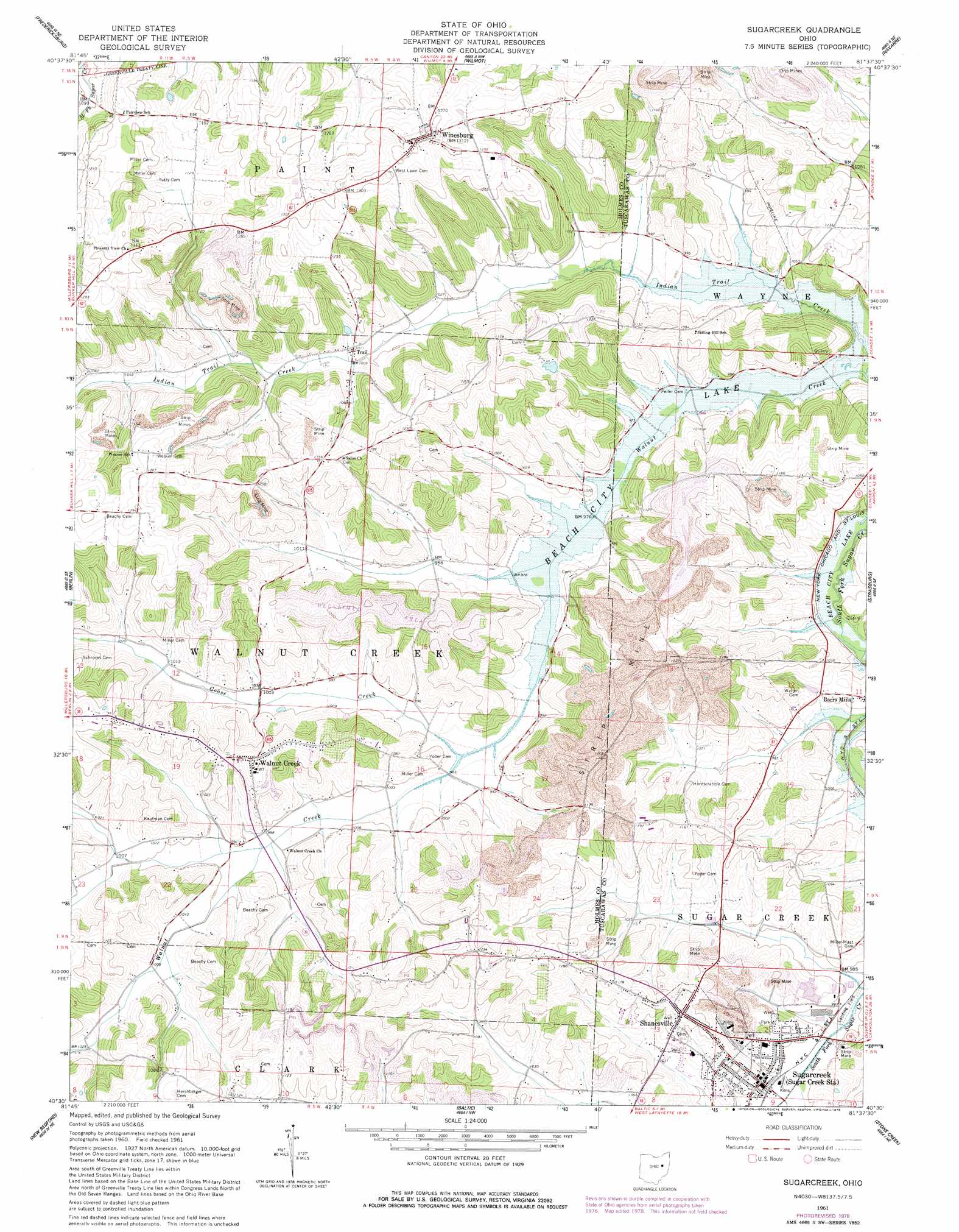
Sugarcreek Topo Map Ohio
To zoom in, hover over the map of Sugarcreek
USGS Topo Quad 40081e6 - 1:24,000 scale
| Topo Map Name: | Sugarcreek |
| USGS Topo Quad ID: | 40081e6 |
| Print Size: | ca. 21 1/4" wide x 27" high |
| Southeast Coordinates: | 40.5° N latitude / 81.625° W longitude |
| Map Center Coordinates: | 40.5625° N latitude / 81.6875° W longitude |
| U.S. State: | OH |
| Filename: | o40081e6.jpg |
| Download Map JPG Image: | Sugarcreek topo map 1:24,000 scale |
| Map Type: | Topographic |
| Topo Series: | 7.5´ |
| Map Scale: | 1:24,000 |
| Source of Map Images: | United States Geological Survey (USGS) |
| Alternate Map Versions: |
Sugarcreek OH 1961, updated 1963 Download PDF Buy paper map Sugarcreek OH 1961, updated 1978 Download PDF Buy paper map Sugarcreek OH 1994, updated 1998 Download PDF Buy paper map Sugarcreek OH 2010 Download PDF Buy paper map Sugarcreek OH 2013 Download PDF Buy paper map Sugarcreek OH 2016 Download PDF Buy paper map |
1:24,000 Topo Quads surrounding Sugarcreek
Wooster |
Orrville |
Dalton |
Massillon |
Canton West |
Holmesville |
Fredericksburg |
Wilmot |
Navarre |
Bolivar |
Millersburg |
Berlin |
Sugarcreek |
Strasburg |
Dover |
Killbuck |
New Bedford |
Baltic |
Stone Creek |
New Philadelphia |
Randle |
Coshocton |
Fresno |
Newcomerstown |
Gnadenhutten |
> Back to 40081e1 at 1:100,000 scale
> Back to 40080a1 at 1:250,000 scale
> Back to U.S. Topo Maps home
Sugarcreek topo map: Gazetteer
Sugarcreek: Populated Places
Limpytown elevation 333m 1092′Shanesville elevation 348m 1141′
Sugarcreek elevation 306m 1003′
Trail elevation 305m 1000′
Unionville elevation 340m 1115′
Walnut Creek elevation 361m 1184′
Winesburg elevation 397m 1302′
Sugarcreek: Post Offices
Trail Post Office (historical) elevation 306m 1003′Walnut Creek Post Office elevation 361m 1184′
Winesburg Post Office elevation 392m 1286′
Sugarcreek: Streams
Goose Creek elevation 296m 971′Sugarcreek digital topo map on disk
Buy this Sugarcreek topo map showing relief, roads, GPS coordinates and other geographical features, as a high-resolution digital map file on DVD:
 map DVD")