Wilmot Topo Map Ohio
To zoom in, hover over the map of Wilmot
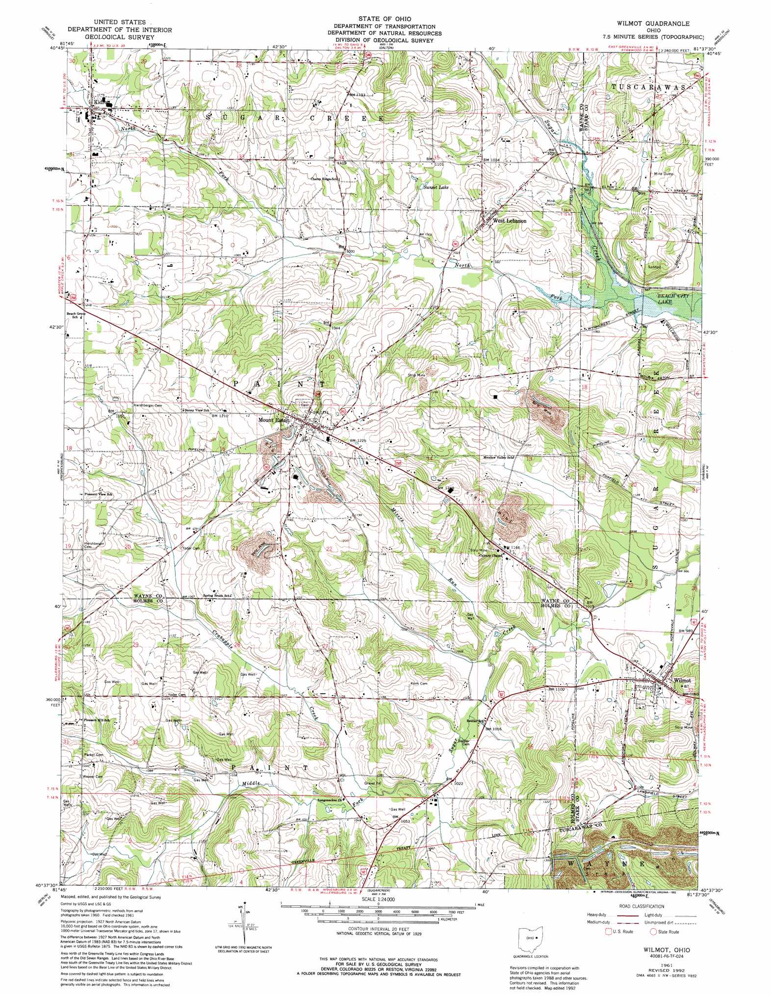
USGS Topo Quad 40081f6 - 1:24,000 scale
| Topo Map Name: | Wilmot |
| USGS Topo Quad ID: | 40081f6 |
| Print Size: | ca. 21 1/4" wide x 27" high |
| Southeast Coordinates: | 40.625° N latitude / 81.625° W longitude |
| Map Center Coordinates: | 40.6875° N latitude / 81.6875° W longitude |
| U.S. State: | OH |
| Filename: | o40081f6.jpg |
| Download Map JPG Image: | Wilmot topo map 1:24,000 scale |
| Map Type: | Topographic |
| Topo Series: | 7.5´ |
| Map Scale: | 1:24,000 |
| Source of Map Images: | United States Geological Survey (USGS) |
| Alternate Map Versions: |
Wilmot OH 1961, updated 1963 Download PDF Buy paper map Wilmot OH 1961, updated 1984 Download PDF Buy paper map Wilmot OH 1961, updated 1992 Download PDF Buy paper map Wilmot OH 1994, updated 1998 Download PDF Buy paper map Wilmot OH 2010 Download PDF Buy paper map Wilmot OH 2013 Download PDF Buy paper map Wilmot OH 2016 Download PDF Buy paper map |
1:24,000 Topo Quads surrounding Wilmot
Creston |
Rittman |
Doylestown |
Canal Fulton |
North Canton |
Wooster |
Orrville |
Dalton |
Massillon |
Canton West |
Holmesville |
Fredericksburg |
Wilmot |
Navarre |
Bolivar |
Millersburg |
Berlin |
Sugarcreek |
Strasburg |
Dover |
Killbuck |
New Bedford |
Baltic |
Stone Creek |
New Philadelphia |
> Back to 40081e1 at 1:100,000 scale
> Back to 40080a1 at 1:250,000 scale
> Back to U.S. Topo Maps home
Wilmot topo map: Gazetteer
Wilmot: Lakes
Sunset Lake elevation 324m 1062′Wilmot: Parks
The Wilderness Center elevation 319m 1046′Wilmot: Populated Places
Cozy Acres elevation 322m 1056′Kidron elevation 336m 1102′
Mount Eaton elevation 381m 1250′
West Lebanon elevation 344m 1128′
Wilmot elevation 309m 1013′
Wilmot: Post Offices
Wilmot Post office elevation 311m 1020′Wilmot: Streams
Crabapple Creek elevation 313m 1026′Misers Run elevation 303m 994′
North Fork Sugar Creek elevation 297m 974′
Wilmot digital topo map on disk
Buy this Wilmot topo map showing relief, roads, GPS coordinates and other geographical features, as a high-resolution digital map file on DVD:
 map DVD")