New Albany Topo Map Ohio
To zoom in, hover over the map of New Albany
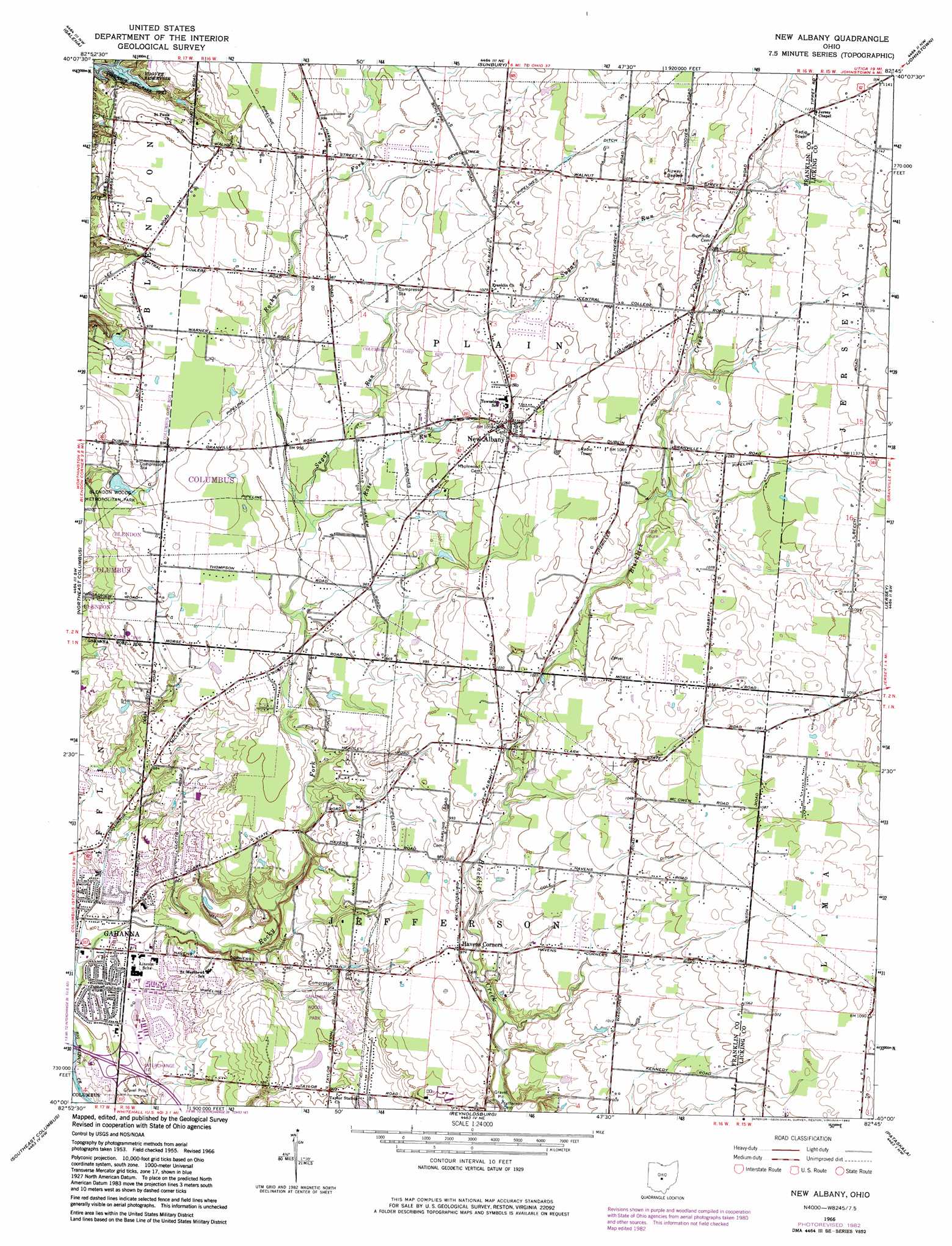
USGS Topo Quad 40082a7 - 1:24,000 scale
| Topo Map Name: | New Albany |
| USGS Topo Quad ID: | 40082a7 |
| Print Size: | ca. 21 1/4" wide x 27" high |
| Southeast Coordinates: | 40° N latitude / 82.75° W longitude |
| Map Center Coordinates: | 40.0625° N latitude / 82.8125° W longitude |
| U.S. State: | OH |
| Filename: | o40082a7.jpg |
| Download Map JPG Image: | New Albany topo map 1:24,000 scale |
| Map Type: | Topographic |
| Topo Series: | 7.5´ |
| Map Scale: | 1:24,000 |
| Source of Map Images: | United States Geological Survey (USGS) |
| Alternate Map Versions: |
New Albany OH 1955, updated 1956 Download PDF Buy paper map New Albany OH 1966, updated 1968 Download PDF Buy paper map New Albany OH 1966, updated 1974 Download PDF Buy paper map New Albany OH 1966, updated 1983 Download PDF Buy paper map New Albany OH 2010 Download PDF Buy paper map New Albany OH 2013 Download PDF Buy paper map New Albany OH 2016 Download PDF Buy paper map |
1:24,000 Topo Quads surrounding New Albany
Delaware |
Kilbourne |
Olive Green |
Centerburg |
Homer |
Powell |
Galena |
Sunbury |
Johnstown |
Fredonia |
Northwest Columbus |
Northeast Columbus |
New Albany |
Jersey |
Granville |
Southwest Columbus |
Southeast Columbus |
Reynoldsburg |
Pataskala |
Millersport |
Commercial Point |
Lockbourne |
Canal Winchester |
Carroll |
Baltimore |
> Back to 40082a1 at 1:100,000 scale
> Back to 40082a1 at 1:250,000 scale
> Back to U.S. Topo Maps home
New Albany topo map: Gazetteer
New Albany: Airports
Gahanna Municipal Heliport elevation 247m 810′Lyttle Airport elevation 322m 1056′
New Albany: Canals
Bevelheimer Ditch elevation 317m 1040′Cole Ditch elevation 311m 1020′
New Albany: Crossings
Interchange 37 elevation 245m 803′New Albany: Dams
Smith Pond Dam elevation 280m 918′Thoreau Pond Dam elevation 289m 948′
New Albany: Parks
Bevelheimer Park elevation 335m 1099′Gahanna Woods Park elevation 270m 885′
Jefferson Community Park elevation 317m 1040′
Plain Township Park elevation 302m 990′
Rose Run Park elevation 308m 1010′
Walden Waterfowl Refuge elevation 291m 954′
New Albany: Populated Places
Beech elevation 346m 1135′Havens Corners elevation 297m 974′
New Albany elevation 312m 1023′
Oakland elevation 327m 1072′
Ovid elevation 306m 1003′
Wonderland (historical) elevation 241m 790′
New Albany: Post Offices
Beech Post Office (historical) elevation 346m 1135′Havens Corners Post Office (historical) elevation 296m 971′
New Albany Post Office elevation 310m 1017′
Ovid Post Office (historical) elevation 306m 1003′
Wonderland Post Office (historical) elevation 241m 790′
New Albany: Reservoirs
Smith Pond elevation 280m 918′Thoreau Pond elevation 289m 948′
New Albany: Streams
Rose Run elevation 289m 948′Sugar Run elevation 288m 944′
New Albany: Woods
Swickard Woods elevation 312m 1023′New Albany digital topo map on disk
Buy this New Albany topo map showing relief, roads, GPS coordinates and other geographical features, as a high-resolution digital map file on DVD:
 map DVD")