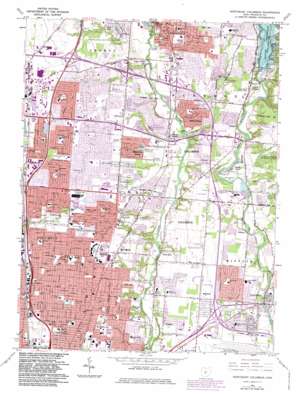
Northeast Columbus Topo Map Ohio
To zoom in, hover over the map of Northeast Columbus
USGS Topo Quad 40082a8 - 1:24,000 scale
| Topo Map Name: | Northeast Columbus |
| USGS Topo Quad ID: | 40082a8 |
| Print Size: | ca. 21 1/4" wide x 27" high |
| Southeast Coordinates: | 40° N latitude / 82.875° W longitude |
| Map Center Coordinates: | 40.0625° N latitude / 82.9375° W longitude |
| U.S. State: | OH |
| Filename: | o40082a8.jpg |
| Download Map JPG Image: | Northeast Columbus topo map 1:24,000 scale |
| Map Type: | Topographic |
| Topo Series: | 7.5´ |
| Map Scale: | 1:24,000 |
| Source of Map Images: | United States Geological Survey (USGS) |
| Alternate Map Versions: |
Northeast Columbus OH 1954, updated 1956 Download PDF Buy paper map Northeast Columbus OH 1964, updated 1966 Download PDF Buy paper map Northeast Columbus OH 1964, updated 1974 Download PDF Buy paper map Northeast Columbus OH 1964, updated 1983 Download PDF Buy paper map Northeast Columbus OH 1964, updated 1983 Download PDF Buy paper map Northeast Columbus OH 1995, updated 1999 Download PDF Buy paper map Northeast Columbus OH 2010 Download PDF Buy paper map Northeast Columbus OH 2013 Download PDF Buy paper map Northeast Columbus OH 2016 Download PDF Buy paper map |
1:24,000 Topo Quads surrounding Northeast Columbus
> Back to 40082a1 at 1:100,000 scale
> Back to 40082a1 at 1:250,000 scale
> Back to U.S. Topo Maps home
Northeast Columbus topo map: Gazetteer
Northeast Columbus: Airports
Worthington Industries Heliport elevation 280m 918′Northeast Columbus: Crossings
Interchange 111 elevation 258m 846′Interchange 112 elevation 256m 839′
Interchange 113 elevation 262m 859′
Interchange 114 elevation 261m 856′
Interchange 115 elevation 262m 859′
Interchange 116 elevation 268m 879′
Interchange 117 elevation 280m 918′
Interchange 27 elevation 258m 846′
Interchange 29 elevation 253m 830′
Interchange 30 elevation 259m 849′
Interchange 32 elevation 260m 853′
Interchange 35 elevation 250m 820′
Northeast Columbus: Dams
Hoover Dam elevation 257m 843′Northeast Columbus: Flats
Cherry Bottom elevation 247m 810′Northeast Columbus: Parks
Alum Creek Arlington Park elevation 238m 780′Alum Creek Park South elevation 244m 800′
Amvet Village Park elevation 246m 807′
Audubon Park elevation 260m 853′
Beechcroft Park elevation 273m 895′
Blendon Woods Metropolitan Park elevation 265m 869′
Boyer Nature Preserve elevation 266m 872′
Castro Park elevation 240m 787′
Chaseland Park elevation 274m 898′
Cherry Bottom Park elevation 247m 810′
Columbus Crew Stadium elevation 255m 836′
Cooke Park elevation 271m 889′
Cooper Park elevation 241m 790′
Devonshire Park elevation 279m 915′
Edward S Thomas Nature Preserve elevation 274m 898′
Forest Park elevation 274m 898′
Friendship Park elevation 238m 780′
Glen Echo Park elevation 258m 846′
Granville Park elevation 271m 889′
Hoover Dam Park elevation 280m 918′
Huber Village Park elevation 262m 859′
Huy Road Park elevation 269m 882′
Innis Park elevation 234m 767′
Inniswood Gardens elevation 265m 869′
Iuka Park elevation 250m 820′
Joan Park elevation 258m 846′
Kenlawn Park elevation 265m 869′
Kiwanis Picnic Park elevation 268m 879′
Linden Park elevation 263m 862′
Northgate Park elevation 271m 889′
Northtowne Park elevation 272m 892′
Parkridge Park elevation 238m 780′
Pontiac Village Park elevation 264m 866′
Ridenour Park elevation 241m 790′
Sharon Woods Metropolitan Park elevation 271m 889′
Somerset Park elevation 253m 830′
Strawberry Farms Park elevation 238m 780′
Walden Park elevation 274m 898′
Walnut Park elevation 263m 862′
Walnut Ridge Park elevation 266m 872′
Walter Cherrington Park elevation 245m 803′
Woodland Memorial Park elevation 276m 905′
Woodside Green Park elevation 244m 800′
Northeast Columbus: Populated Places
Blendon Corner elevation 246m 807′Central College elevation 272m 892′
Clinton elevation 268m 879′
East Linden elevation 251m 823′
Gahanna elevation 242m 793′
Gould Park elevation 248m 813′
Huber Ridge elevation 253m 830′
Linden elevation 263m 862′
Mifflinville elevation 261m 856′
Minerva Park elevation 258m 846′
Moores Corners elevation 266m 872′
Parks Mills elevation 249m 816′
Pinhook elevation 259m 849′
Sharon elevation 270m 885′
Wildwood Springs (historical) elevation 250m 820′
Northeast Columbus: Post Offices
Central College Post Office (historical) elevation 272m 892′Gahanna Post Office (historical) elevation 242m 793′
Mifflinville Post Office (historical) elevation 260m 853′
Park Mills Post Office (historical) elevation 248m 813′
Northeast Columbus: Reservoirs
City of Columbus Sludge Pond elevation 247m 810′City of Columbus Sludge Pond elevation 248m 813′
Hoover Reservoir elevation 257m 843′
Schrock Lake elevation 267m 875′
Northeast Columbus: Streams
Rocky Fork elevation 233m 764′Northeast Columbus digital topo map on disk
Buy this Northeast Columbus topo map showing relief, roads, GPS coordinates and other geographical features, as a high-resolution digital map file on DVD:


